Lane validity prediction method and prediction system based on multi-dimensional features

A prediction method and effective technology, applied in the direction of road vehicle traffic control system, prediction, traffic control system, etc., can solve the problem of ignoring the connectivity of the road network, and achieve the effect of improving accuracy and safety

Active Publication Date: 2022-02-18
WUHAN ZHONGHAITING DATA TECH CO LTD
View PDF8 Cites 0 Cited by
  • Summary
  • Abstract
  • Description
  • Claims
  • Application Information

AI Technical Summary

Problems solved by technology

The above methods rely solely on the trajectory density and ignore the connectivity of the road network. In fact, the topological connectivity of the lanes reflected by the sparse trajectory may be crucial.

Method used


Image

  • Lane validity prediction method and prediction system based on multi-dimensional features
  • Lane validity prediction method and prediction system based on multi-dimensional features
  • Lane validity prediction method and prediction system based on multi-dimensional features

Examples


Embodiment 1

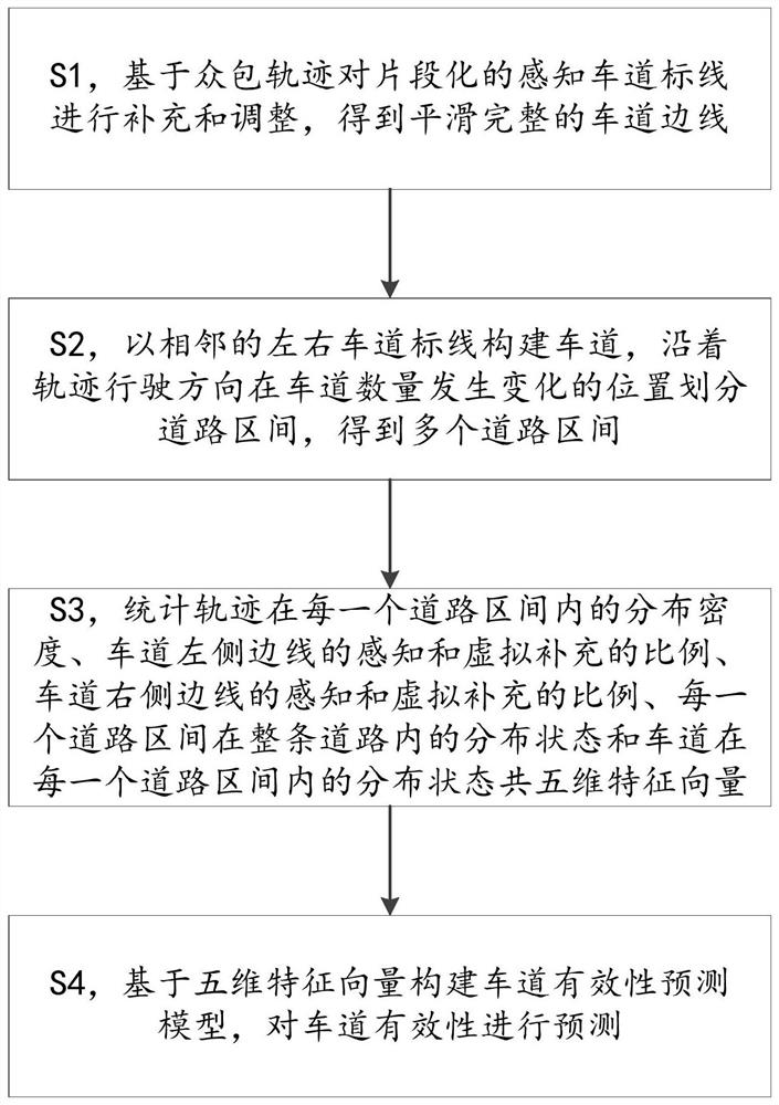
[0025] see figure 1 , provides a lane availability prediction method based on multi-dimensional features, which mainly includes the following steps:

[0026] S1, supplement and adjust the fragmented perceived lane markings based on crowdsourcing trajectories, and obtain smooth and complete lane edges.

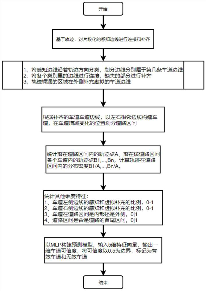
[0027] As an embodiment, supplementing and adjusting the perceived fragmented lane markings based on the crowdsourced trajectory to obtain a smooth and complete lane edge includes: following the direction of trajectory, the fragmented perceived lane markings are Classify the horizontal distribution on the road, and stitch the perceived lane markings belonging to the same lane edge; for the missing area in the middle, refer to the nearby crowdsourcing trajectory to complete it, and get the complete lane edge.

[0028] Among them, the ground markings collected by the crowdsourcing collection vehicle are fragmented due to occlusion or wear and other reasons, and the perceived lan...

Embodiment 2

[0040] A lane effectiveness prediction method based on multi-dimensional features, see figure 2 , the prediction method mainly includes the following steps: supplement and adjust the fragmented perceived lane markings based on the crowdsourcing trajectory to obtain a smooth and complete lane edge; construct a lane with adjacent left and right lane markings, and drive along the trajectory in the The location where the number of lanes changes divides the road section, and multiple road sections are obtained; the distribution density of crowdsourcing trajectories in each road section, the ratio of perception and virtual supplement of the left side of the lane, and the perception and virtual complement of the right side of the lane are calculated. The supplementary proportion, the distribution state of each road section in the whole road, and the distribution state of lanes in each road section have a total of five-dimensional feature vectors; based on the five-dimensional feature...

Embodiment 3

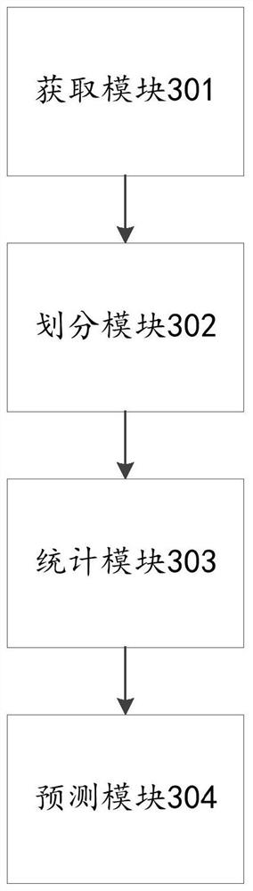
[0043] A lane availability prediction system based on multi-dimensional features, such as image 3 As shown, the prediction system includes an acquisition module 301, a division module 302, a statistics module 303 and a prediction module 304, wherein:

[0044] The acquisition module 301 is configured to supplement and adjust the fragmented perceived lane markings based on crowdsourcing trajectories, and acquire smooth and complete lane sidelines;

[0045] The division module 302 is used to construct lanes with adjacent left and right lane markings, and divide road sections at positions where the number of lanes changes along the track driving direction to obtain multiple road sections;

[0046] Statistical module 303, used to count the distribution density of crowdsourcing trajectories in each road section, the ratio of perception and virtual supplement of the left side of the lane, the ratio of perception and virtual supplement of the right side of the lane, the ratio of each...


PUM


Abstract

The invention provides a lane effectiveness prediction method and prediction system based on multi-dimensional features. The method comprises steps of supplementing and adjusting a fragmented perception lane marking line based on a crowdsourcing trajectory, and obtaining a smooth and complete lane sideline; constructing lanes by using adjacent left and right lane marking lines, and dividing road intervals at positions where the number of the lanes changes along the track driving direction to obtain a plurality of road intervals; counting five-dimensional feature vectors related to each road interval; and constructing a lane validity prediction model based on the five-dimensional feature vector, and predicting lane validity. According to information such as distribution density of tracks in a lane, spatial distribution of the lane on a road surface, perception proportion and supplementary proportion of left and right lane sidelines and the like, modeling is carried out through the basic characteristics, and credibility of existence of the lane is predicted, so invalid lanes generated due to offset tracks or sparse tracks are removed; and precision and the safety of a high-precision map are improved.

Description

technical field [0001] The present invention relates to the field of high-precision maps, and more specifically, to a lane effectiveness prediction method and prediction system based on multi-dimensional features. Background technique [0002] Building a crowdsourced map by collecting data from batches of low-cost crowdsourcing collection vehicles is one of the mainstream methods for high-precision map formation. Lines are supplemented and adjusted to build a lane-level high-precision map. [0003] Since the collection equipment of the crowdsourcing collection vehicle itself is low-cost, it is relatively normal to have trajectories drifting in environments such as building shelters and bad weather. For abnormal trajectories, vehicle kinematics and Kalman filtering can be combined. Filtering is performed, but for those trajectories that deviate slightly from the lane, the filtering effect is not so ideal. The lane sidelines speculated by these deviated trajectories and perc...

Claims


Application Information

Patent Timeline
IPC IPC(8): G08G1/01G06Q10/04G06Q50/30
CPCG08G1/0125G08G1/0137G06Q10/04G06Q50/40
Inventor 覃飞杨尹玉成石涤文蔡晨刘奋
Owner WUHAN ZHONGHAITING DATA TECH CO LTD
Why Eureka
Try Eureka