A GNSS-based fine positioning auxiliary system and working method for offshore platforms

An offshore platform and auxiliary system technology, applied in satellite radio beacon positioning systems, radio wave measurement systems, instruments, etc., can solve problems such as low automation and poor visualization, achieve efficient construction, improve automation, and ensure Safety in place effect

Active Publication Date: 2022-04-29
SHANDONG UNIV OF SCI & TECH
View PDF9 Cites 0 Cited by
  • Summary
  • Abstract
  • Description
  • Claims
  • Application Information

AI Technical Summary

Problems solved by technology

[0003] The present invention proposes a GNSS-based precise positioning auxiliary system and working method for offshore platforms, which solves the problems of low automation and poor visualization of precise positioning operation position acquisition in the prior art

Method used


Image

  • A GNSS-based fine positioning auxiliary system and working method for offshore platforms
  • A GNSS-based fine positioning auxiliary system and working method for offshore platforms
  • A GNSS-based fine positioning auxiliary system and working method for offshore platforms

Examples


Embodiment Construction

[0047] The specific embodiment of the present invention will be further described below in conjunction with specific embodiment:

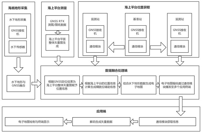
[0048] A GNSS-based precise positioning auxiliary system for offshore platforms, including a data acquisition terminal, a data fusion processing terminal, an application terminal and a communication link;

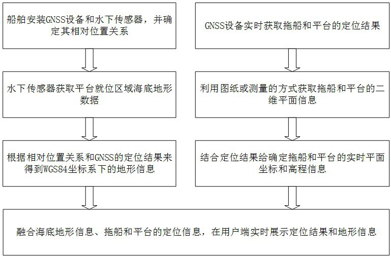
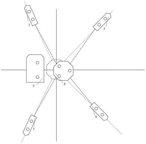
[0049]The data acquisition end is connected to a topographic mapping sensor, RTK equipment, GNSS equipment and a data fusion processing end, the topographic sensor collects seabed terrain information, the RTK equipment performs plane measurement of an offshore platform, and the GNSS equipment is installed on an offshore carrier And obtain the real-time position of the carrier at sea;

[0050] The data fusion processing end fuses the seabed terrain information, the plane measurement information of the offshore platform, and the real-time position information calculated by the GNSS equipment to generate an electronic map, and sends the current loc...


PUM


Abstract

The invention discloses a GNSS-based precise positioning auxiliary system and a working method for an offshore platform, belonging to the technical field of GNSS marine applications, and solves the problem of low degree of automation in obtaining the platform position during the offshore platform positioning process. The system consists of underwater terrain acquisition end, tugboat and offshore platform positioning end, data fusion processing end and application end. The underwater terrain acquisition end uses ships as carriers, equipped with GNSS and underwater measurement sensors, to obtain seabed terrain data with position information; the tugboat and offshore platform positioning end install multiple GNSS receivers on the tugboat and platform, through differential positioning The position and attitude information of the carrier can be obtained in real time in a real-time manner; the data fusion processing end performs secondary processing by fusing the seabed terrain data and the positioning results of the tugboat and the platform, and generates electronic map data for assisting the tugboat operation; the application end decodes and draws the electronic map , used to assist the precise positioning of offshore platforms.

Description

technical field [0001] The invention discloses a GNSS-based precise positioning auxiliary system and a working method for an offshore platform, belonging to the technical field of GNSS marine applications. Background technique [0002] The method of satellite differential positioning can obtain centimeter-level and millimeter-level positioning accuracy. Because it has greatly changed the traditional surveying industry, it has gradually replaced measuring equipment such as total stations and levels in many fields. With the exploration and development of marine resources, more and more offshore platforms have been put into use. The positioning operation of offshore platforms is a high-risk joint operation, which requires a short safety distance between platforms, which requires the positioning accuracy of offshore platforms to reach the meter level or above. At present, the platform position determination methods for precise positioning operations on offshore platforms are mo...

Claims


Application Information

Patent Timeline
Patent Type & Authority Patents(China)
IPC IPC(8): G01S19/43G01S19/37
CPCG01S19/43G01S19/37
Inventor 王胜利王凯迪刘以旭王进王磊
Owner SHANDONG UNIV OF SCI & TECH
Why Eureka
Try Eureka