Supercharge Your Innovation With Domain-Expert AI Agents!

Underwater terrain erosion and deposition evolution analysis method and device for navigation channel

A technology of underwater topography and analysis method, which is applied in the analysis of erosion and silting evolution of underwater terrain in waterways, and in the field of analysis devices for underwater terrain scouring and silting evolution of waterways, which can solve the problems that the analysis of underwater terrain in waterways is not comprehensive enough, etc.

Active Publication Date: 2022-03-08
北京恒济引航科技股份有限公司
View PDF14 Cites 0 Cited by
  • Summary
  • Abstract
  • Description
  • Claims
  • Application Information

AI Technical Summary

Problems solved by technology

[0005] In order to solve the problem that the underwater terrain analysis of the channel is not comprehensive enough in the prior art, this application provides a method for analyzing the erosion and silting evolution of the underwater terrain of the channel

Method used


Image

  • Underwater terrain erosion and deposition evolution analysis method and device for navigation channel
  • Underwater terrain erosion and deposition evolution analysis method and device for navigation channel
  • Underwater terrain erosion and deposition evolution analysis method and device for navigation channel

Examples


Embodiment Construction

[0039] In the following description, numerous specific details are set forth in order to provide a thorough understanding of the application. However, the present application can be implemented in many other ways different from those described here, and those skilled in the art can make similar promotions without violating the connotation of the present application. Therefore, the present application is not limited by the specific implementation disclosed below.

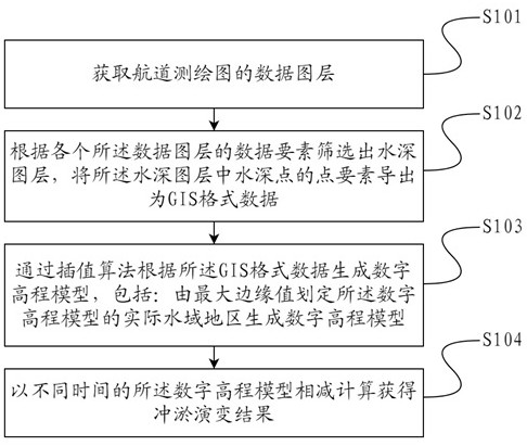
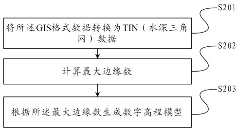
[0040] The application provides a method for analyzing the erosion and siltation evolution of underwater terrain of a waterway, comprising: obtaining the data layers of the waterway mapping; filtering out the water depth layer according to the data elements of each said data layer, and storing The point elements of the sounding point are exported as GIS format data; the digital elevation model is generated according to the GIS format data through an interpolation algorithm, including: the actual water area of ​​the di...


PUM


Abstract

The invention discloses an underwater terrain erosion and deposition evolution analysis method for a channel. The method comprises the following steps: acquiring a data map layer of a channel surveying and mapping map; a water depth map layer is screened out according to the data elements of all the data map layers, and point elements of water depth points in the water depth map layer are exported as GIS format data; generating a digital elevation model according to the GIS format data through an interpolation algorithm, wherein the digital elevation model is generated by delimiting an actual water area of the digital elevation model through a maximum marginal value; and carrying out subtraction calculation on the digital elevation models at different times to obtain an erosion and deposition evolution result. According to the method, the erosion and deposition evolution result is obtained through subtraction of different time digital elevation models, and the channel underwater terrain erosion and deposition condition and the erosion and deposition amount can be accurately described.

Description

technical field [0001] The present application relates to a channel underwater terrain analysis technology, in particular to a channel underwater terrain erosion and silting evolution analysis method. The present application also relates to a device for analyzing the erosion and siltation evolution of the underwater topography of the waterway. Background technique [0002] For a certain river section, if the amount of sediment transported from the upstream is greater than the sediment-carrying capacity of the river section, the excess sediment will be deposited, which is siltation. If the amount of sediment transported from the upstream is less than the sediment-carrying capacity of the river section, the sediment in the river section will be washed away, which is called scouring. [0003] For rivers navigable by ships, it can accurately analyze the sedimentation and scour results of the underwater terrain, effectively judge the evolution direction of the waterway, provide ...

Claims


Application Information

Patent Timeline
Patent Type & Authority Applications(China)
IPC IPC(8): G06T17/05G06T17/20G06F30/20
CPCG06T17/05G06T17/20G06F30/20
Inventor 王金波满建昊苏东峰杨帆丁皓
Owner 北京恒济引航科技股份有限公司
Features
  • R&D
  • Intellectual Property
  • Life Sciences
  • Materials
  • Tech Scout
  • Unparalleled Data Quality
  • Higher Quality Content
  • 60% Fewer Hallucinations
Learn More