Balanced surveying and mapping device unfolded in flight based on unmanned aerial vehicle

A surveying and mapping device and unmanned aerial vehicle technology, applied in the field of geological surveying and mapping, can solve the problems of surveying and mapping devices that are prone to dead angles in surveying and mapping, affect the surveying and mapping effect, and have different surveying and mapping angles of view, and achieve the effect of ensuring no dead angles in surveying and mapping and good retractability

Active Publication Date: 2022-03-15
SHANDONG GEO-SURVEYING & MAPPING INST
View PDF12 Cites 0 Cited by
  • Summary
  • Abstract
  • Description
  • Claims
  • Application Information

AI Technical Summary

Problems solved by technology

[0003] However, as far as UAV surveying and mapping devices are currently in use, the surveying and mapping angles of view are different when the surveying and mapping devices are at different focal lengths.

Method used


Image

  • Balanced surveying and mapping device unfolded in flight based on unmanned aerial vehicle
  • Balanced surveying and mapping device unfolded in flight based on unmanned aerial vehicle
  • Balanced surveying and mapping device unfolded in flight based on unmanned aerial vehicle

Examples


Embodiment

[0034] Example: Please refer to Figure 1 to Figure 9 :

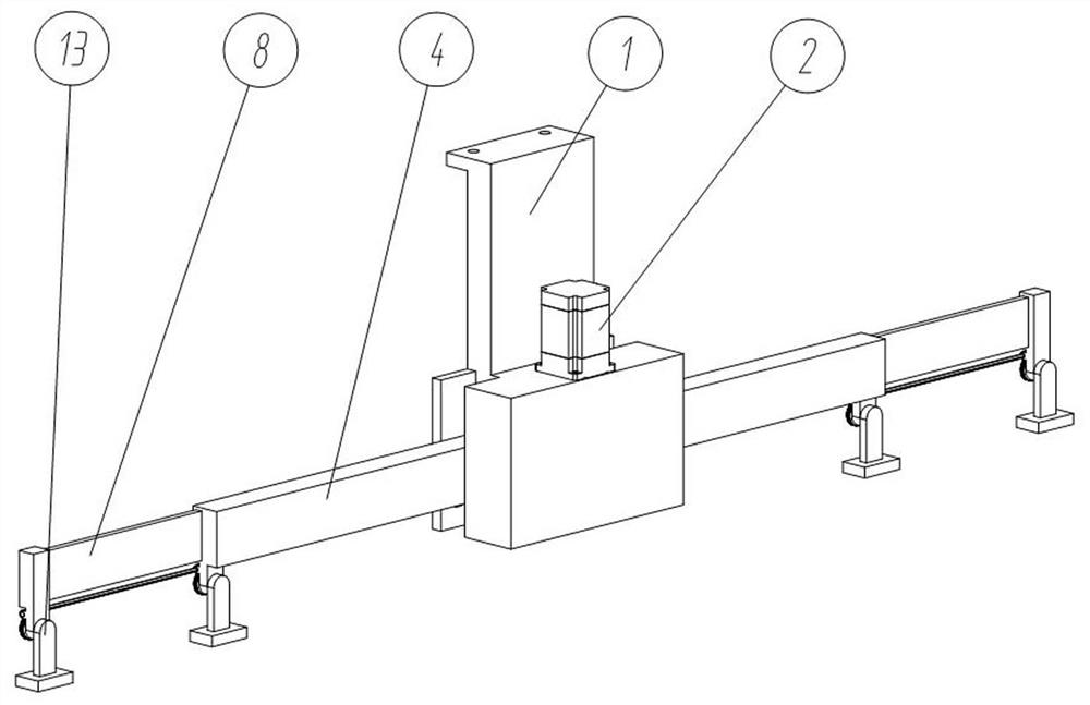
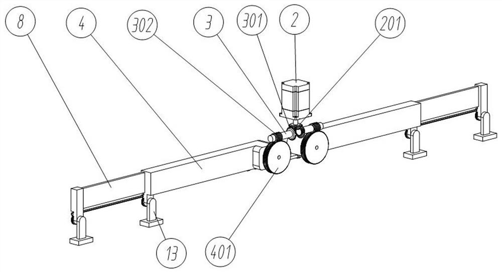
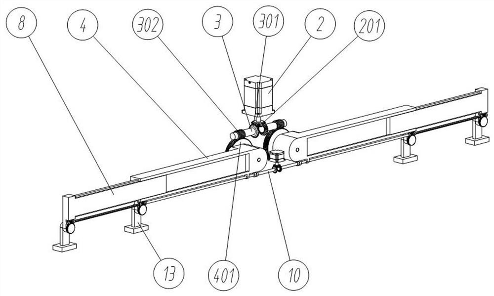
[0035] The present invention proposes a balanced surveying and mapping device based on unmanned aerial vehicles deployed in flight, including: a mounting base 1; a swing driving part 2, which is fixedly connected to the front upper end surface of the mounting base 1; a retractable swing arm 4 , the retractable swing arm 4 is provided with two groups in total, and the two groups of retractable swing arms 4 are respectively rotated and connected to the left and right sides of the installation base 1; the swing transmission mechanism is arranged inside the installation base 1, and the swing drive member 2 The two groups of retractable swing arms 4 are driven to swing through the swing transmission mechanism; in addition, according to the embodiment of the present invention, as figure 2 As shown, the swing transmission mechanism also includes: a swing active bevel gear 201, which is coaxially fixedly connected to the rota...


PUM


Abstract

The invention provides a balance surveying and mapping device unfolded in flight based on an unmanned aerial vehicle, and relates to the technical field of geological surveying and mapping. The swing driving part is fixedly connected to the upper end surface of the front part of the mounting base; the two sets of folding and unfolding swing arms are arranged, and the two sets of folding and unfolding swing arms are rotationally connected to the left side and the right side of the mounting base correspondingly; the swing transmission mechanism is arranged in the mounting base, and the swing driving piece drives the two sets of folding and unfolding swing arms to swing through the swing transmission mechanism. The problems that surveying and mapping view angles are different when surveying and mapping devices are in different focal sections, and when the surveying and mapping view angles are small, surveying and mapping dead angles easily occur between adjacent surveying and mapping devices, and surveying and mapping effects are affected are solved. Swing folding and unfolding of the folding and unfolding swing arms and stretching and retracting of the telescopic plates are achieved, the good folding and unfolding capacity is achieved, swing of the four sets of detector installation bases is achieved, the installation angles of the detector installation bases are adjusted, the surveying and mapping requirements at different heights and different visual angles are met, and no-dead-corner surveying and mapping are guaranteed.

Description

technical field [0001] The invention relates to the technical field of geological surveying and mapping, in particular to a balanced surveying and mapping device deployed in flight based on an unmanned aerial vehicle. Background technique [0002] In recent years, with the development of drones, more and more drones have been used in the surveying and mapping process. In the process of balanced surveying and mapping, drones generally use multiple groups of zoom image acquisition devices to fly horizontally. To survey and map the earth's surface, when the UAV is at different heights, the image acquisition device will use different focal lengths for surveying and mapping. [0003] However, as far as the current UAV surveying and mapping devices are in use, the surveying and mapping angles of view are different when the surveying and mapping devices are at different focal lengths. Contents of the invention [0004] In view of this, the present invention provides a balance su...

Claims


Application Information

Patent Timeline
Patent Type & Authority Applications(China)
IPC IPC(8): B64D47/08
CPCB64D47/08B64U2101/30
Inventor 郑秀菊李晓峰薛伟
Owner SHANDONG GEO-SURVEYING & MAPPING INST
Why Eureka
Try Eureka