
System and method for driving route planning of unmanned vehicles for surveying, mapping and inspection

A driving route and route planning technology, which is applied in the field of unmanned vehicle driving route planning system for surveying, mapping and inspection, can solve the problems of unable to identify crowds, small coverage of monitoring points, and not equipped with unmanned vehicles for inspection, etc. Creativity and sense of science and technology, improving safety and security capabilities, and meeting the effect of fire protection needs

Active Publication Date: 2022-05-31
江苏智慧汽车研究院有限公司
View PDF5 Cites 0 Cited by
  • Summary
  • Abstract
  • Description
  • Claims
  • Application Information

AI Technical Summary

Problems solved by technology

[0004] In a large number of parks across the country, there are monitoring points, but most of them are not equipped with unmanned vehicle inspections, but only use manual inspections. However, with the disappearance of the demographic dividend, the security industry may face up to 55% Turnover rate, many units will find it increasingly difficult to recruit qualified security guards, it is estimated that more than 60% of the current employees will be over 55 years old
Such boring and repetitive jobs will be difficult to attract outstanding young talents to join in the future. Therefore, the use of unmanned vehicles for patrol inspection and security is the development trend of the industry. For a small number of parks equipped with unmanned vehicle inspections , the monitoring points it can provide have a small coverage area, low pixel accuracy, and there are angle blind spots. For example, people gather in the corner to smoke in the park. The monitoring points can only capture the back or side, and cannot identify the specific actions of the crowd. Cigarette butts dropped after smoking can easily cause fire and cause unnecessary losses

Method used


Image

  • System and method for driving route planning of unmanned vehicles for surveying, mapping and inspection
  • System and method for driving route planning of unmanned vehicles for surveying, mapping and inspection
  • System and method for driving route planning of unmanned vehicles for surveying, mapping and inspection

Examples


Embodiment Construction

[0073] Below in conjunction with the accompanying drawings in the embodiments of the present invention, the technical solutions in the embodiments of the present invention will be clearly and completely

[0103]

[0105] The initial training set weight distribution is recorded as:

[0106]

[0109]

[0112]

[0115]

[0117]

[0119]

[0128] Select the location of the person with the largest number of positioning occurrences as the first place of arrival;

[0130] Command the surveying and mapping inspection unmanned vehicle to drive according to the driving route of the surveying and mapping inspection unmanned vehicle.

[0135] Take the average value of the interval time as the value of X (in seconds), take Y as the result output, and obtain 10 groups of numbers

[0136]

[0139]

[0141] Each weight is 0.1;

[0143]

[0145] Select a weak classifier with the lowest current error rate as the t-th basic classifier, and calculate the weak classification

[0146]

[0149]

[0150] ...


PUM


Abstract

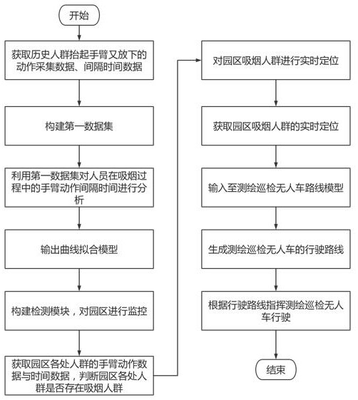
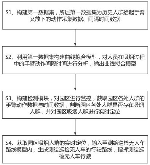
The invention discloses a driving route planning system and method for an unmanned vehicle for surveying, mapping and inspection, and belongs to the technical field of unmanned vehicles for surveying, mapping and inspection. The system includes a first data set building module, a curve fitting model building module, a random acquisition module, a real-time positioning module, and a route planning module; the output end of the first data set building module is connected to the curve fitting model building module The input end is connected; the output end of the curve fitting model building module is connected with the input end of the random acquisition module; the output end of the random acquisition module is connected with the input end of the real-time positioning module; The output terminal of the real-time positioning module is connected with the input terminal of the route planning module. The invention can solve the problems of lack of personnel, low inspection accuracy, and poor security measures in the scenic spot inspection industry, and greatly improve the intellectualization and technological level of the inspection field.

Description

System and method for driving route planning of unmanned vehicles for surveying, mapping and inspection technical field The present invention relates to the technical field of unmanned vehicles for surveying and mapping inspections, in particular to a travel route rule for unmanned vehicles for surveying and mapping inspections. planning systems and methods. Background technique In foreign countries, products similar to unmanned patrol vehicles are currently only used in military patrol scenarios, and products in the civilian field are temporarily used. No, domestic unmanned products with integrated ground-air functions are still in the blank field. Unmanned patrol industry The exhibition is still immature. According to statistics, there are nearly 1 million parks, campuses and communities across the country, nearly 100,000 closed scenic spots, docks, closed There are nearly 200,000 industrial parks, but most of them do not use unmanned vehicles for inspection. Su...

Claims


Application Information

Patent Timeline
Patent Type & Authority Patents(China)
IPC IPC(8): G06V20/52G06V20/56G06V10/774G06K9/62G01C21/20
CPCG01C21/20G06F18/214
Inventor 计宏时英理郭绪谢丹
Owner 江苏智慧汽车研究院有限公司
Learn More