Ship positioning data-oriented space-time grid and tree fusion storage method

A positioning data, space-time technology, applied in database indexing, geographic information database, structured data retrieval, etc., can solve the problem of not considering the time series characteristics of positioning data, etc., and achieve the effect of quickly narrowing the search range

Pending Publication Date: 2022-04-26
HANGZHOU DIANZI UNIV
View PDF0 Cites 0 Cited by
  • Summary
  • Abstract
  • Description
  • Claims
  • Application Information

AI Technical Summary

Problems solved by technology

However, in the time series scenario, the above indexes do not

Method used


Image

  • Ship positioning data-oriented space-time grid and tree fusion storage method
  • Ship positioning data-oriented space-time grid and tree fusion storage method
  • Ship positioning data-oriented space-time grid and tree fusion storage method

Examples


Embodiment Construction

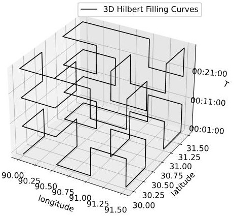
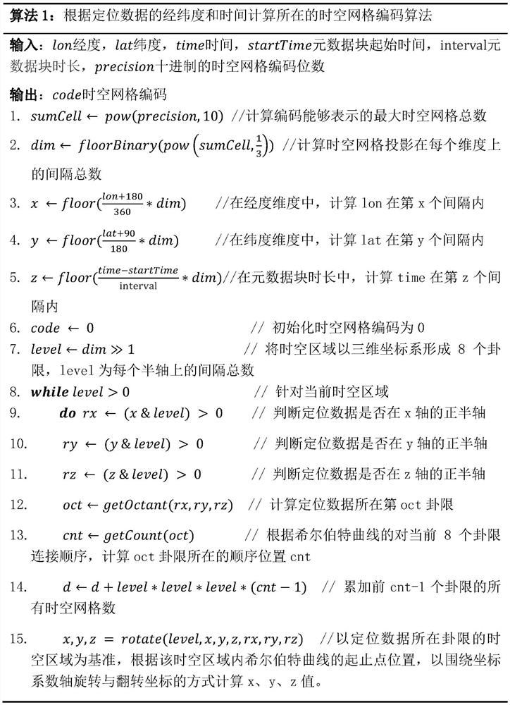
[0023] The following will be combined with figure 1 And the specific implementation steps further illustrate the present invention:

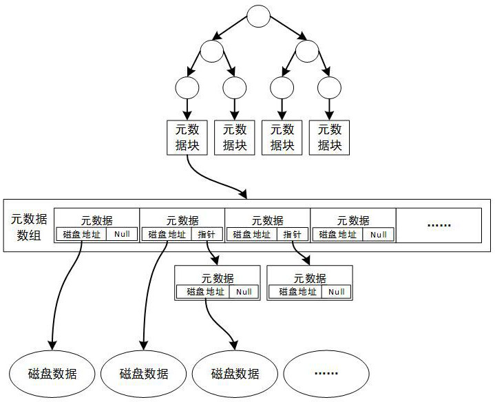
[0024] Step (1): The attributes of ship positioning data include longitude, latitude, time, equipment number, speed, direction, temperature, etc. Aiming at the multi-key-value feature of ship positioning data, three dimensions of time, longitude and latitude are used to construct a space-time grid to realize the metadata modeling of a single ship positioning data in the space-time grid. The metadata attributes include: the ship positioning The latitude and longitude, time and disk address of the data, etc.

[0025] The above space-time grid is divided according to time, longitude and latitude at fixed intervals. In this embodiment, grid division is performed by taking the time interval of 10 minutes and the latitude and longitude intervals of 0.5 degrees as an example.

[0026] Step (2): Aiming at the timing characteristics of massive ship po...


PUM


Abstract

The invention discloses a space-time grid and tree fusion storage method for ship positioning data. The method comprises the following steps: constructing a space-time grid by adopting three dimensions of time, longitude and latitude, and modeling metadata of single ship positioning data in the space-time grid; the metadata are fragmented according to a time range to form metadata blocks, and the metadata blocks are managed by adopting a B + tree; constructing space-time grid codes in the metadata blocks, and sequentially storing the metadata into a metadata array according to an ascending order of the space-time grid codes; in the data storage process, as time goes on, metadata blocks and metadata of the metadata blocks are automatically established in a fragmentation mode according to the time range, and meanwhile ship positioning data are stored to storage nodes. According to the method, space-time grid codes are used as metadata indexes, and metadata can be quickly searched according to space-time conditions; according to the method, metadata is fragmented according to a time range to form metadata blocks, and the metadata blocks are managed by adopting a B + tree, so that the search range of target data is quickly narrowed.

Description

technical field [0001] The invention relates to the field of marine ship positioning data storage, in particular to a storage method oriented to space-time grid and tree fusion of ship positioning data. Background technique [0002] With the popularization of positioning terminals in marine vessels, a large amount of ship positioning data is continuously recorded. In the face of actual scenarios of ship collisions, shipwrecks, and accident rescue, LBS (services based on geographical location data) need to query the historical trajectory of ships in any time and space. A reasonable storage model and index can fundamentally improve the query performance of ship point data. However, traditional relational databases are difficult to support the storage of massive ship positioning data. At the same time, although the NoSQL database can meet the storage of massive general data, it does not specifically optimize the storage and query of time-space sequence data. Therefore, the st...

Claims


Application Information

Patent Timeline
IPC IPC(8): G06F16/29G06F16/22G06F16/2455
CPCG06F16/29G06F16/2246G06F16/2282G06F16/2456
Inventor 徐传奇张纪林任永坚曾艳袁俊峰薛梅婷欧东阳
Owner HANGZHOU DIANZI UNIV
Why Eureka
Try Eureka