High-precision map drawing method based on Internet of Vehicles

A technology of map drawing and Internet of Vehicles, applied in the field of map drawing, can solve the problems of slow transmission of collected data, users misread map signs, poor map instructions, etc., to avoid wrong paths, to be iconic, to improve accuracy and time-sensitive effect

Pending Publication Date: 2022-04-29
合肥湛达智能科技有限公司
View PDF0 Cites 0 Cited by
  • Summary
  • Abstract
  • Description
  • Claims
  • Application Information

AI Technical Summary

Problems solved by technology

However, most of the maps they involve are displayed on two-dimensional maps; the map instructions are poor, and users are prone to misreading the map signs; especially for pedestrian users, because of direction problems and marker problems, they often go the wrong way The phenomenon occurs; some enterprises have also begun to explore the use of the Internet of Vehicles for map drawing, but the existing way of using the Internet of Vehicles for data collection has the problem of slow data transmission speed; therefore, the present invention provides a high-precision Mapping method for solving the above problems

Method used


Image

  • High-precision map drawing method based on Internet of Vehicles

Examples


Embodiment Construction

[0026] The technical solutions of the present invention will be clearly and completely described below in conjunction with the embodiments. Apparently, the described embodiments are only some of the embodiments of the present invention, not all of them. Based on the embodiments of the present invention, all other embodiments obtained by persons of ordinary skill in the art without making creative efforts belong to the protection scope of the present invention.

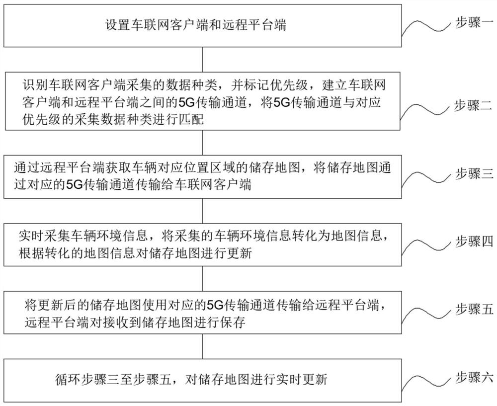
[0027] Such as figure 1 As shown, a high-precision map drawing method based on the Internet of Vehicles, the specific method includes:

[0028] Step 1: Set up the Internet of Vehicles client and the remote platform end. The Internet of Vehicles client is set in the vehicle and is based on the vehicle network. There are several Internet of Vehicles clients for collecting information. The Internet of Vehicles client is used for collecting Vehicle environment information, vehicle environment information includes position...


PUM


Abstract

The invention discloses a high-precision map drawing method based on the Internet of Vehicles, and belongs to the technical field of map drawing, and the method specifically comprises the steps that an Internet of Vehicles client and a remote platform end are arranged, the Internet of Vehicles client is used for collecting vehicle environment information, and the remote platform end is used for processing the information collected by the Internet of Vehicles client; identifying data types collected by the Internet of Vehicles clients, marking priorities corresponding to the collected data types, establishing a plurality of 5G transmission channels between the Internet of Vehicles clients and the remote platform end based on a 5G slicing technology, and marking priorities for the established 5G transmission channels; the map is subjected to three-dimensional processing, so that a user can identify the direction more conveniently, and navigation errors are avoided; the 5G slicing technology is fully utilized, the transmission efficiency of the collected data is improved, three building states are preset when the building model is established, subsequent state replacement is facilitated, and the method is more convenient, visual and symbolic.

Description

technical field [0001] The invention belongs to the technical field of map drawing, in particular to a high-precision map drawing method based on the Internet of Vehicles. Background technique [0002] As an integral part of unmanned intelligent driving technology, high-precision maps have been widely used in the field of automotive intelligent driving, providing possibility and feasibility for intelligent driving functions. Both traditional map data providers and Internet companies that provide map services can visualize map data to a certain extent. However, most of the maps they involve are displayed on two-dimensional maps; the map instructions are poor, and users are prone to misreading the map signs; especially for pedestrian users, because of direction problems and marker problems, they often go the wrong way The phenomenon occurs; some enterprises have also begun to explore the use of the Internet of Vehicles for map drawing, but the existing way of using the Intern...

Claims


Application Information

Patent Timeline
Patent Type & Authority Applications(China)
IPC IPC(8): G01C21/00G01C21/32
CPCG01C21/3833G01C21/3896G01C21/32
Inventor 张中周鹤
Owner 合肥湛达智能科技有限公司
Why Eureka
Try Eureka