
Oil reservoir modeling method based on geological time domain coordinates

A modeling method and time domain technology, applied in the field of reservoir modeling based on geological time domain coordinates, can solve the problem that the geological model cannot be established, the real structure and the geological conditions of the complex underground sedimentary strata cannot be completely followed, and the geological statistics cannot be satisfied. Algorithm preconditions, etc.

Pending Publication Date: 2022-06-24
马瑞伦
View PDF0 Cites 0 Cited by
  • Summary
  • Abstract
  • Description
  • Claims
  • Application Information

AI Technical Summary

Problems solved by technology

Conventional modeling techniques are based on columnar (P i l l ar) grids; however, when Y-shaped or dipping faults develop, the results of this modeling approach can lead to fault deformation or failure to consider all faults in the modeling
At the same time, the conventional modeling method will cause the geometric shape of the grid element (Grid cel l) to change, which cannot meet the prerequisites for the subsequent application of geostatistical algorithms
[0003] Ordinary geological grids are limited by fault constraints, and the geological model needs to give assumptions, which cannot fully follow the real structure and geological conditions of complex underground sedimentary strata, so it is impossible to establish a geological model that is closer to the objective reality
[0004] For any geological structure, it is difficult to be faithful to complex strata, to achieve accurate geostatistics, to preserve the volume and distance information of geological bodies; to solve the problem of seismic model grids, structural model grids, attribute model grids, and reservoir fluids The technical gap caused by the limitations of traditional modeling techniques between grids cannot run through the entire link of subsurface knowledge research
[0005] The existing technology cannot realize 3D global interpretation and 3D leveling; cannot establish a water seal model for velocity analysis, and cannot realize formation-constrained velocity modeling
[0006] The algorithm library and modules of the existing technology cannot support multi-core parallel and GPU computing, cannot perform data management flexibly, and cannot provide conditions for digital integrated management of oil reservoirs

Method used


Image

  • Oil reservoir modeling method based on geological time domain coordinates

Examples


Embodiment

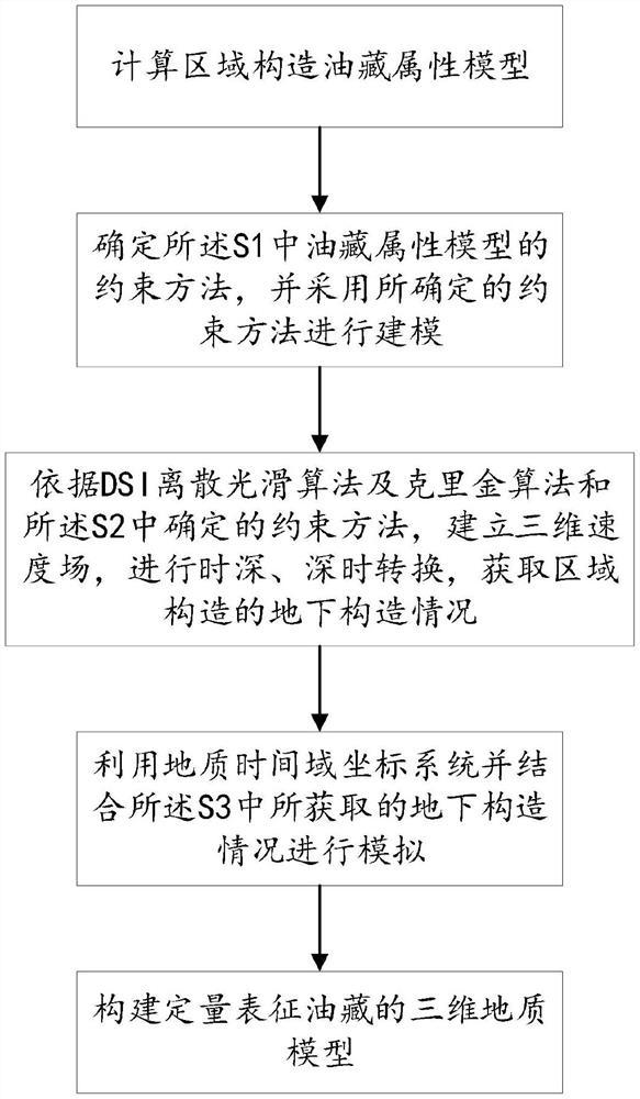
[0029] It should be noted that SKUA-GOCAD TM The modeling method breaks through the conventional modeling ideas, and introduces the new theory of "geological time domain coordinate system" into the reservoir modeling technology. The so-called geological time domain coordinate system refers to the staged calibration of the development process of the entire structure or oil reservoir according to the geological time. By dividing the geological time domain, the geological modeling is carried out, which overcomes the limitation of ordinary geological grids constrained by faults. . The reservoir modeling geological grid based on UVT technology can be arbitrarily cut and displaced by faults; the geological model does not need to be given any premise and assumptions, and completely follows the real structure and the geological conditions of the complex underground sedimentary strata, and establishes a more objective reality. Geological Model.

[0030] Palladium SKUA's unique grid s...


PUM


Abstract

The invention discloses an oil reservoir modeling method based on geological time domain coordinates. The method comprises the steps that S1, a regional structure oil reservoir attribute model is calculated; s2, determining a constraint method of the oil reservoir attribute model in the S1, and modeling by adopting the determined constraint method; s3, establishing a three-dimensional velocity field according to a DS I discrete smoothing algorithm, a Kriging algorithm and the constraint method determined in the S2, and performing time-depth and depth-time conversion to obtain an underground structure condition of the regional structure; s4, simulating by utilizing a geological time domain coordinate system and combining the underground structure condition obtained in the S3; and S5, constructing a three-dimensional geologic model for quantitatively representing the oil reservoir. By applying the method, the limitation of fault constraint on a common geological grid is overcome. An oil reservoir modeling geological grid based on the UVT technology can be randomly cut and displaced by a fault; the geologic model does not need to give any prerequisite assumption condition, completely follows the geological conditions of the real structure and the underground complex sedimentary stratum, and establishes a geologic model which is closer to the objective reality.

Description

technical field [0001] The invention relates to the technical field of oil and gas field development, in particular to an oil reservoir modeling method based on geological time domain coordinates. Background technique [0002] In the field of petroleum exploration and development, 3D modeling technology and 3D mesh modeling are generally the same among various general modeling application software. Conventional modeling techniques are based on cylindrical grids; however, when Y-type or dipping faults develop, the result of this modeling approach can lead to fault deformation or failure to account for all faults in the modeling. At the same time, the conventional modeling method will cause the geometric shape of the grid element to change, which cannot meet the preconditions for the subsequent application of geostatistical algorithms. [0003] Ordinary geological grids are limited by the constraints of faults, and the geological model needs to be given premise and assumption...

Claims


Application Information

Patent Timeline
Patent Type & Authority Applications(China)
IPC IPC(8): G06F30/20G06T17/05
CPCG06F30/20G06T17/05
Inventor 马瑞伦
Owner 马瑞伦
Learn More