
Remote sensing image sea-land segmentation method

A remote sensing image, sea and land segmentation technology, applied in image analysis, neural learning methods, image enhancement and other directions, can solve the problem of inaccurate segmentation of remote sensing images at sea and land boundaries, and achieve multi-scale expression capabilities, enhanced capabilities, and improved accuracy. sexual effect

Pending Publication Date: 2022-06-24
PLA STRATEGIC SUPPORT FORCE INFORMATION ENG UNIV PLA SSF IEU
View PDF0 Cites 4 Cited by
  • Summary
  • Abstract
  • Description
  • Claims
  • Application Information

AI Technical Summary

Problems solved by technology

[0006] The purpose of the present invention is to provide a method for segmenting land and sea in remote sensing images to solve the problem of inaccurate segmentation of land and sea boundaries in remote sensing images

Method used


Image

  • Remote sensing image sea-land segmentation method
  • Remote sensing image sea-land segmentation method
  • Remote sensing image sea-land segmentation method

Examples


Embodiment Construction

[0036] The specific embodiments of the present invention will be further described below with reference to the accompanying drawings.

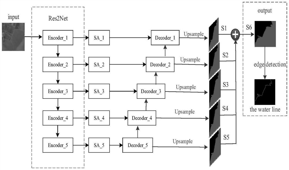
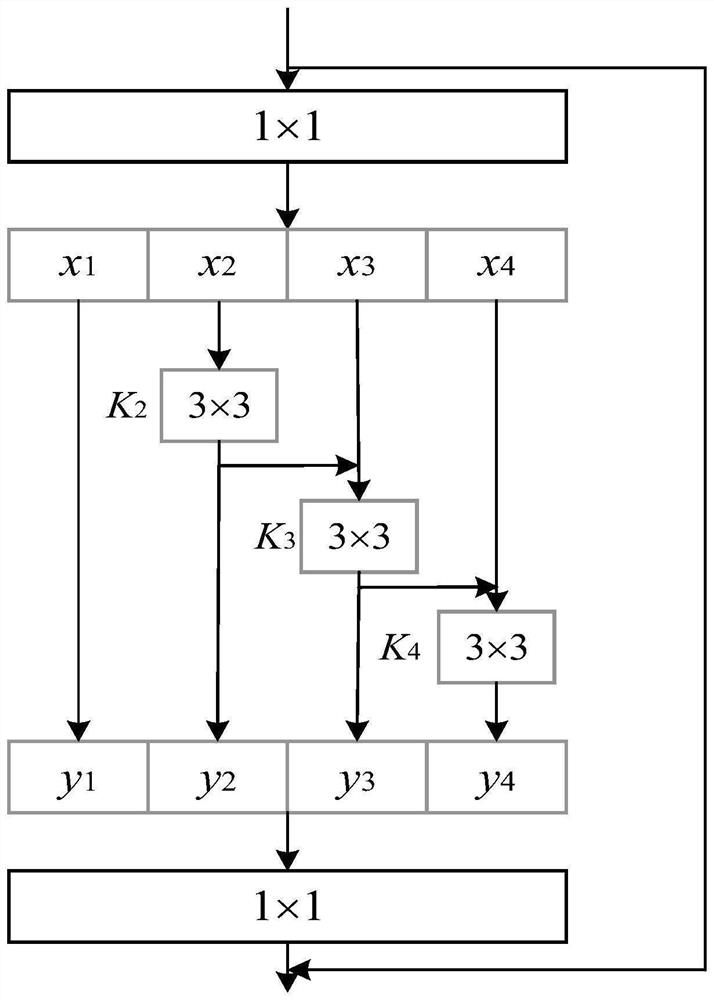
[0037] The invention adopts the network model of the encoding-decoding structure as the sea and land segmentation model of the remote sensing image, wherein the new backbone network Res2Net is used as the encoder to extract the multi-scale features of the image, and after the feature extraction of each layer, the compression and attention modules are used for processing. , in order to strengthen the network's ability to extract weak boundaries; when decoding, each feature map is upsampled (Upsample) as the side output of the network, and the side outputs are combined to achieve multi-level feature fusion, and the results of each feature fusion are used. The deep supervision strategy is adopted, and finally the edge detection is performed on the sea and land segmentation results output by the network, so as to obtain the water edge, so as to rea...


PUM


Abstract

The invention relates to a remote sensing image sea-land segmentation method, and belongs to the technical field of remote sensing image processing. According to the invention, an architecture mode of an encoder and a decoder is adopted, extraction of features of different sizes is realized by using a multi-layer encoding module of a Res2Net network, and feature enhancement is carried out on feature maps of different scales by using a compression and attention module so as to enhance sea-land weak boundary information; in the training process, a deep supervision strategy is used, output results of different decoding modules are respectively trained, the ability of network learning of target boundary information is enhanced, and the accuracy of remote sensing image sea-land boundary segmentation is further improved. And two groups of remote sensing image data sets containing different coast types are selected for experiments, and the result shows that a more accurate sea-land segmentation result and a clearer and more complete sea-land boundary can be obtained.

Description

technical field [0001] The invention relates to a remote sensing image sea and land segmentation method, which belongs to the technical field of remote sensing image processing. Background technique [0002] With the rapid development of remote sensing technology, the means of obtaining remote sensing data have become more diverse, and the spatial resolution, temporal resolution, spectral resolution and radiometric resolution of remote sensing images have also been continuously improved, providing sufficient data for the study of large-scale coastal areas. support. In remote sensing images, the effective distinction between ocean areas and land areas can achieve rapid and high-precision segmentation of sea and land, which has important application value for coastline extraction, identification of islands and reefs, and nearshore target detection. The traditional sea and land segmentation includes threshold segmentation method, active contour model method, region growth meth...

Claims


Application Information

Patent Timeline
Patent Type & Authority Applications(China)
IPC IPC(8): G06T7/10G06T7/13G06N3/04G06N3/08
CPCG06T7/10G06T7/13G06N3/08G06T2207/10032G06T2207/20081G06T2207/20084G06N3/045
Inventor 郭海涛卢俊龚志辉阎晓东张衡林雨准刘相云高慧
Owner PLA STRATEGIC SUPPORT FORCE INFORMATION ENG UNIV PLA SSF IEU
Learn More