Marine surveying and mapping underwater target three-dimensional visualization processing system

A technology for underwater targets and processing systems, applied to radio wave measurement systems, surveying and navigation, and measurement devices, can solve problems such as measurement data query and analysis of ocean depth sounding, improve the level of application technology, and solve application forms single effect

Pending Publication Date: 2022-07-15
山东海慧勘察测绘有限公司
View PDF0 Cites 0 Cited by
  • Summary
  • Abstract
  • Description
  • Claims
  • Application Information

AI Technical Summary

Problems solved by technology

[0004] Aiming at the deficiencies of the prior art, the present invention provides a three-dimensional visualization processing system for m

Method used


Image

  • Marine surveying and mapping underwater target three-dimensional visualization processing system

Examples


Embodiment 1

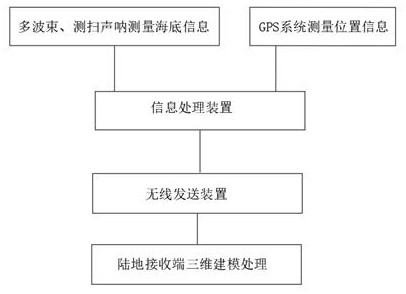
[0022] like figure 1 As shown, an embodiment of the present invention provides a three-dimensional visualization processing system for underwater targets in marine surveying and mapping, including a multi-beam bathymetric system, a side scan sonar system, a GPS system, an information processing device, a wireless sending device, and a land receiving end. The depth system and the side scan sonar system can effectively measure the seabed topography and the shape of the underwater target. The multi-beam bathymetry system and the side scan sonar system are connected to the underwater target acquisition computer of the surveying and mapping ship. The multi-beam bathymetry system uses the transmission energy The transducer array transmits sound waves covered by a wide sector to the seabed, uses the receiving transducer array to receive narrow beams of the sound waves, and forms the irradiation footprints of the seabed terrain through the orthogonality of the directions of the transmi...


PUM


Abstract

The invention provides a marine surveying and mapping underwater target three-dimensional visualization processing system, which comprises a multi-beam sounding system, a side-scan sonar system, a GPS system, an information processing device, a wireless transmitting device and a land receiving end, and is characterized in that the multi-beam sounding system and the side-scan sonar system can effectively measure the submarine topography and the shape of an underwater target; the land receiving end matches data sent by the multi-beam sounding system and the side-scan sonar system with physical properties (including but not limited to salinity and temperature of seawater) of seawater in the area, and reduces deviation of seawater topographic data through a seawater scattering attenuation formula. Data sent by the multi-beam sounding system and the side-scan sonar system are in one-to-one correspondence with GPS information, submarine topographies and underwater target conditions at different positions can be effectively obtained, and more accurate topographic information can be effectively obtained through matching calculation of the data and physical properties of seawater in the area.

Description

technical field [0001] The invention relates to the technical field of marine surveying and mapping, in particular to a three-dimensional visualization processing system for underwater targets in marine surveying and mapping. Background technique [0002] In the process of ocean surveying and mapping, the underwater target point data can provide the attribute information and spatial information of the location and nature of the underwater target. Technical guidance. At present, the existing marine surveying and mapping systems can only perform some simple processing on the data collected by the underwater target detection equipment, and provide simple forms of data records, texts and pictures, and lack systematic, informational and visual processing and management methods. This makes it difficult to query and analyze measurement data, and cannot make quick and accurate judgments and decisions, resulting in a waste of information resources. In addition, acoustic instruments ...

Claims


Application Information

Patent Timeline
IPC IPC(8): G01S7/52G01S15/86G01S15/89G01C13/00
CPCG01S15/86G01S15/89G01S7/52004G01C13/00
Inventor 李英超郑献之王海周超李保强
Owner 山东海慧勘察测绘有限公司
Why Eureka
Try Eureka