Large-area three-dimensional slope stability modeling method based on GIS

A modeling method and stability technology, applied in instrumentation, geometric CAD, design optimization/simulation, etc.

Pending Publication Date: 2022-08-05
CHONGQING INST OF GEOLOGY & MINERAL RESOURCES +1
View PDF0 Cites 0 Cited by
  • Summary
  • Abstract
  • Description
  • Claims
  • Application Information

AI Technical Summary

Problems solved by technology

The fact that such working examples of GRASS GIS parallel modules do not exist, or even ra...

Method used


Image

  • Large-area three-dimensional slope stability modeling method based on GIS
  • Large-area three-dimensional slope stability modeling method based on GIS
  • Large-area three-dimensional slope stability modeling method based on GIS

Examples


Embodiment Construction

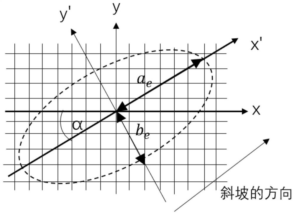
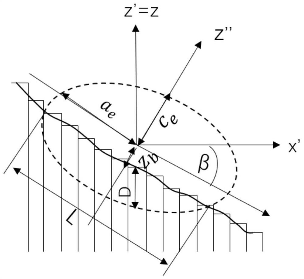
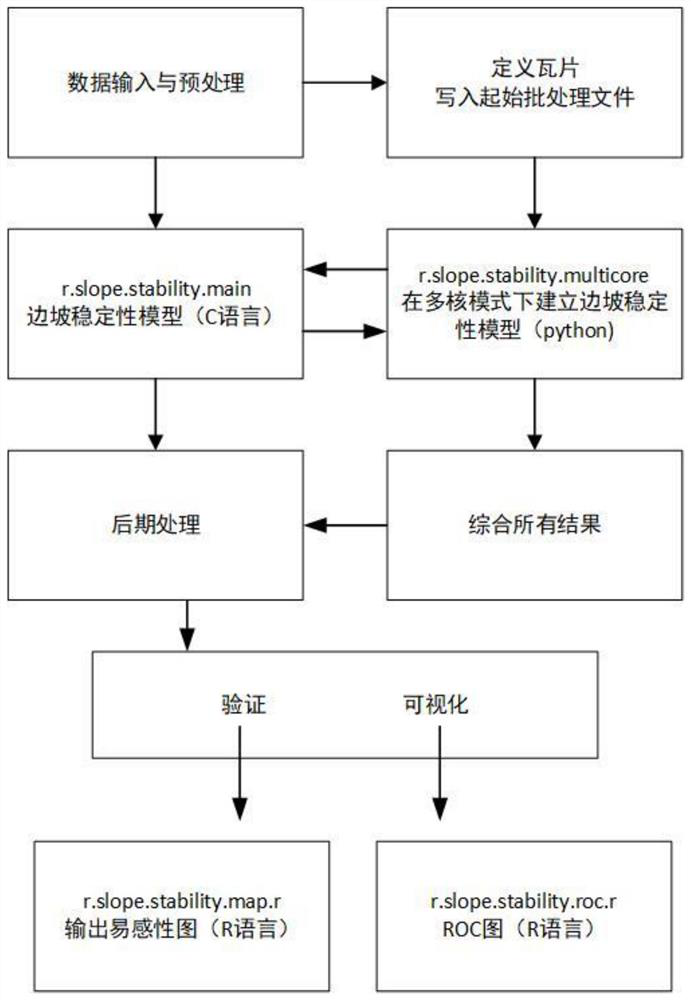
[0039] The present invention will be further described in detail below in conjunction with the accompanying drawings. like figure 1 , 2 , 3, in the present invention, S1 represents step 1, S101 represents step 01 in S1, S102 represents step 02 in S1, and so on.

[0040] Let the study area be the S area.

[0041] S1: Data input and preprocessing:

[0042] r.slope.stability. is the raster module of the open source software package GRASS GIS 6.4, which utilizes the Python programming language for data management, preprocessing and postprocessing tasks. The 5th and 95th percentiles of landslide length L, width W, and L / W ratio of selected shallow landslides were used to constrain the randomization of possible sliding ellipsoids. Since most landslides in Zone S are not very mobile, use the entire landslide area instead of just the steep slopes. The geotechnical characteristics of the sediments in the study area were obtained by conducting direct shear tests on samples collecte...


PUM


Abstract

The invention relates to the technical field of landslide prevention and control, in particular to a GIS-based large-area three-dimensional slope stability modeling method, which comprises the following steps: S1, inputting data; s2, an r.slope.stability model is established, and an r.slope.stability model is established; s3, testing the number of the ellipsoids; s4, solving the problems of computer memory and operation time; s5, parameterizing the model; s6, result verification and model visualization are carried out; according to the technical scheme of the method, the calculation time and the model result of the three-dimensional slope stability model r.slope.stability based on the GIS are optimized, the safety coefficient and the slope instability probability are calculated, and the time required for large-area slope stability modeling is greatly shortened.

Description

technical field [0001] The invention relates to the technical field of landslide prevention and control, in particular to a large-area three-dimensional slope stability modeling method based on GIS. Background technique [0002] Landslides are one of the major natural disasters with huge and widespread impacts around the world and cause human and socio-economic losses. The spatiotemporal prediction of landslide risk still has great uncertainty, and landslide sensitivity assessment is very important for the identification of landslide risk. [0003] Landslide susceptibility is the spatial probability of landslide occurrence based on local topographic conditions, and landslide susceptibility can be determined using statistical and physics-based models. The most common is the spatial probability of shallow landslides in small watersheds, this modeling relies on the use of a physics-based deterministic model, based on the concept of limit equilibrium resulting in a factor of sa...

Claims


Application Information

Patent Timeline
IPC IPC(8): G06F30/13G06F30/20G06F119/14
CPCG06F30/13G06F30/20G06F2119/14Y02A10/23
Inventor 陈立川杨海清梁丹李卓航廖蔚茗杨勇王琦闫奇丁忠昊
Owner CHONGQING INST OF GEOLOGY & MINERAL RESOURCES
Why Eureka
Try Eureka