AGV laser radar performance evaluation method

A technology of laser radar and evaluation method, which is applied in the direction of radio wave measurement system, instrument, etc., can solve the problems of increasing error and cumbersome implementation process, and achieve the effect of ensuring stable operation and good practicability

CN114879169APending Publication Date: 2022-08-09CHINA JILIANG UNIV
2 Cites 0 Cited by

Patent Information

Authority / Receiving Office
CN · China
Patent Type
Applications(China)
Current Assignee / Owner
Publication Date
2022-08-09

Smart Images

  • Figure 1
    Figure 1
  • Figure 2
    Figure 2
  • Figure 3
    Figure 3
Patent Text Reader

Abstract

The invention provides a method for evaluating the performance of an AGV laser radar, and the method comprises the steps: enabling the AGV laser radar to scan a plurality of fixed standard target balls at a plurality of places on the ground, and obtaining the point cloud data of the surface of each target ball; performing spherical surface fitting calculation on the target ball surface point cloud data obtained by scanning by using a least square method to obtain sphere center coordinates obtained by scanning each target ball at different places; according to the sphere center coordinates, calculating the sphere center distance between every two target spheres when the AGV laser radar scans at different places; and evaluating the performance of the AGV laser radar according to the difference condition of the sphere center distances of a plurality of target spheres obtained by scanning the two same target spheres at different places. The evaluation method has the advantages of low cost, simplicity in operation and reliable result.
Need to check novelty before this filing date? Find Prior Art

Description

technical field

[0001] The patent of the present invention relates to the technical field of AGV laser radar, and mainly relates to a method for evaluating the performance of AGV laser radar. Background technique

[0002] The navigation methods of AGV mainly include coordinate navigation, electromagnetic navigation, inertial navigation, GPS navigation, visual navigation, laser navigation, etc. Among them, laser navigation has been widely used with the advantages of high precision and high performance. In most production workshops with AGV applications, AGVs need to run continuously for a long time, which places higher requirements on the performance of AGVs and their lidars. For AGVs, the accuracy and stability of its navigation method are very important for the operation of the entire AGV system. Due to factors such as the installation position of the lidar and the measurement error of the lidar itself, its measurement accuracy restricts the performance of the lidar. [0...

Examples

Embodiment Construction

[0026] The specific embodiments of the present invention will be described below with reference to the accompanying drawings.

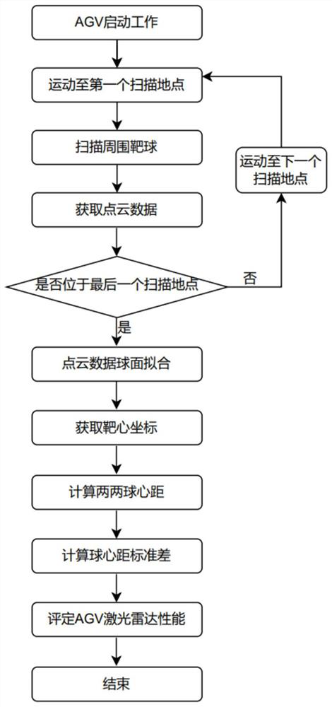
[0027] refer to figure 1 , figure 2 and image 3 , a method for evaluating the performance of AGV lidar, characterized in that it includes the following steps:

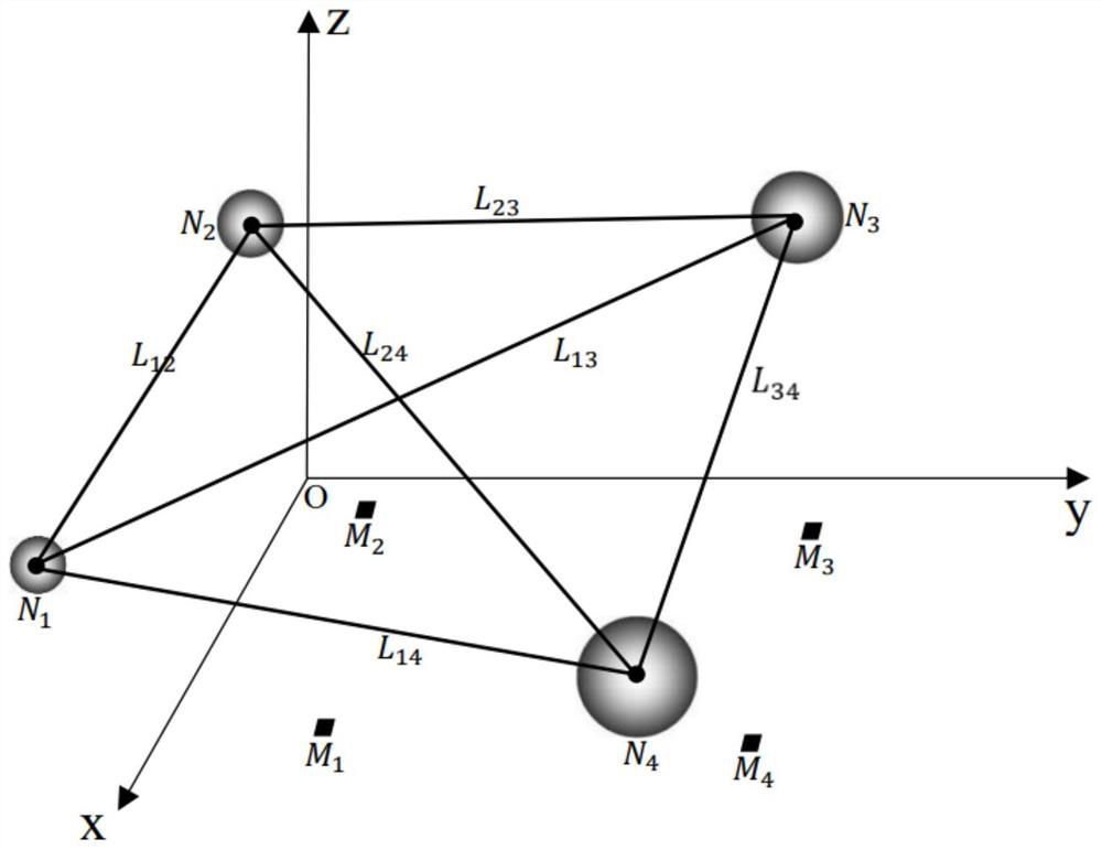
[0028] a). Establish the spatial coordinate system of the AGV lidar scanning, that is, the x-axis, y-axis, and z-axis of the Cartesian coordinate system are established with the upper left corner of the test site space rectangle as the origin O, such as figure 2 shown;

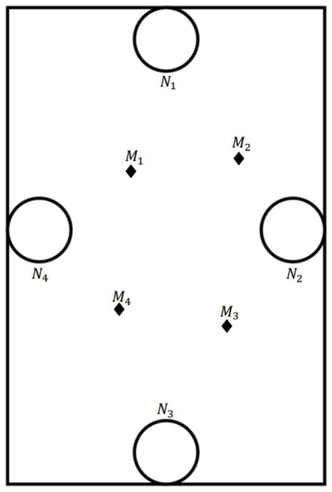
[0029] b). Arrange 4 standard target balls around the test field, such as image 3 , numbered N 1 , N 2 , N 3 , N 4 , the diameters are d 1 =50mm, d 2 =80mm, d 3 =110mm, d 4 =140mm, the coordinates are C N1 =(3000mm, 50mm, 150mm), C N2 =(50mm, 100mm, 150mm), C N3 =(100mm, 35000mm, 150mm), C N4 = (25000mm, 3000mm, 150mm);

[0030] c). On the ground of the test site, select 4 scattered locations, such as im...