Open GIS development middleware system

A middleware and geographic information system technology, applied in the field of GIS development middleware system, can solve the problems of poor product openness and integration, restrict product promotion and application, restrict development and implementation efficiency, etc., and achieve easy expansion and excellent cross-platform. Portability, the effect of speeding up the expansion

Inactive Publication Date: 2006-10-04
杭州天丽科技有限公司
View PDF0 Cites 0 Cited by
  • Summary
  • Abstract
  • Description
  • Claims
  • Application Information

AI Technical Summary

Problems solved by technology

These have resulted in a great waste of human resources for developers, resulting in poor openness and integration of products, limiting the improvement of development and implementation efficiency, thereby limiting the promotion and application of products

Method used


Image

  • Open GIS development middleware system
  • Open GIS development middleware system

Examples


Embodiment Construction

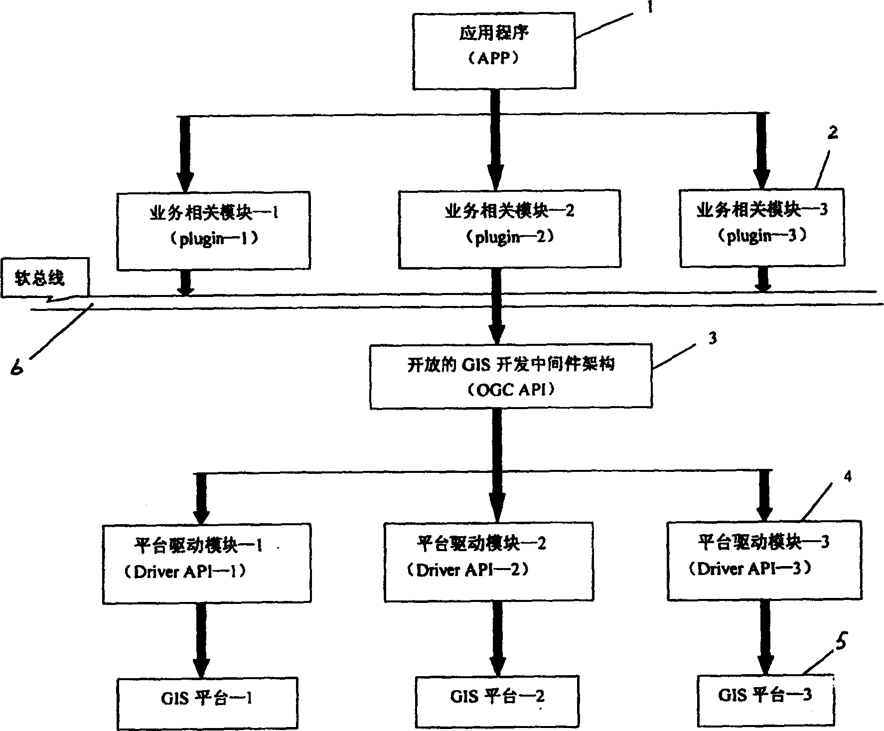
[0015] Such as figure 1 As shown, this embodiment is divided into five layers, the top layer is the application program 1, the second layer is the business-related layer, which is composed of 3 business-related modules 2, the third layer is the open GIS development middleware framework 3, and the fourth layer The layer is the platform driver layer, which is composed of three platform driver modules 4, and the bottom layer is three GIS platforms 5. in:

[0016] GIS platform 5 refers to the GIS platforms existing in the market, in this example, the Smallworld platform, the Arc / Info platform and the Geomedia platform of Intergraph.

[0017] The platform driver layer (Driver API layer) composed of three platform driver modules 4 is the lowest layer in the OGC specification, and this layer is composed of more than 300 functions. It abstractly describes the basic operations of the GIS platform, such as zooming in, zooming out, etc.; this layer is closely related to the GIS platfor...


PUM


Abstract

In the invention, the middleware system is utilized to connect different GIS platform as well as realize transplant and extension of GIS platform. The service implementation is separated from GIS platform so as to reach the goal of promoting resources sharing, and raising development efficiency. Technical scheme for solving the said issue is as follows. Multiple modules located on next lower layer of application program in system are relevant to services, and multiple modules of driving platform are located on next higher layer of each GIS platform. Middleware open structure for developing GIS is inserted between service-related layer and platform drive layer, making separation between services and GIS platform. The soft bus coordinates functions between modules relevant to service realization. The system is suitable for developing GIS system of electricity distribution as well as other GIS systems.

Description

technical field [0001] The invention relates to an open GIS development middleware system developed for a distribution network GIS (Geographic Information System), referred to as OGC (Open GIS Connectivity) architecture. Not only for the development of power distribution GIS system, but also for the development of other GIS systems. Background technique [0002] At present, the distribution network GIS system market has the following characteristics: There are many mainstream GIS platforms with very different development methods in the market; different users will require different GIS platforms to realize the distribution network GIS system, and users need to use GIS system To integrate various power distribution services. [0003] In view of the above situation, the practice of other developers is to establish a development team for each GIS platform to complete the realization from the platform to the business. In this way, the more platforms, the more developers are nee...

Claims


Application Information

Patent Timeline
Patent Type & Authority Patents(China)
IPC IPC(8): G06F17/00G06Q50/00G06F19/00H02B13/02
Inventor 杨国平倪立洲
Owner 杭州天丽科技有限公司
Why Eureka
Try Eureka