Downhole positioning system, device and method based on radio sensor network

A technology of sensor network and positioning system, which is applied in the field of underground positioning system based on wireless sensor network, can solve the problems of low positioning accuracy, inaccurate positioning, and dependent positioning accuracy, so as to reduce losses, speed up rescue progress, improve management level and The effect of work efficiency

Inactive Publication Date: 2005-11-09
INST OF COMPUTING TECH CHINESE ACAD OF SCI
View PDF0 Cites 48 Cited by
  • Summary
  • Abstract
  • Description
  • Claims
  • Application Information

AI Technical Summary

Problems solved by technology

There are some problems in this positioning system: first, the positioning accuracy is low, and the positioning accuracy depends on the distance between the roadway interrogation devices. In the general electronic identification card positioning method, the distance between the roadway interrogation devices is on the order of tens of meters, so the positioning system The positioning accuracy is only on the order of tens of meters, and it cannot be precisely positioned. It can only provide limited help for emergency rescue
In addition, radio frequency cards are generally passive cards and can only answer fixed inquiries
In the event of an accident, employees only rely on electronic identification cards to determine the approximate location before the accident, but cannot communicate with the roadway interrogation device two-way

Method used


Image

  • Downhole positioning system, device and method based on radio sensor network
  • Downhole positioning system, device and method based on radio sensor network
  • Downhole positioning system, device and method based on radio sensor network

Examples


Embodiment Construction

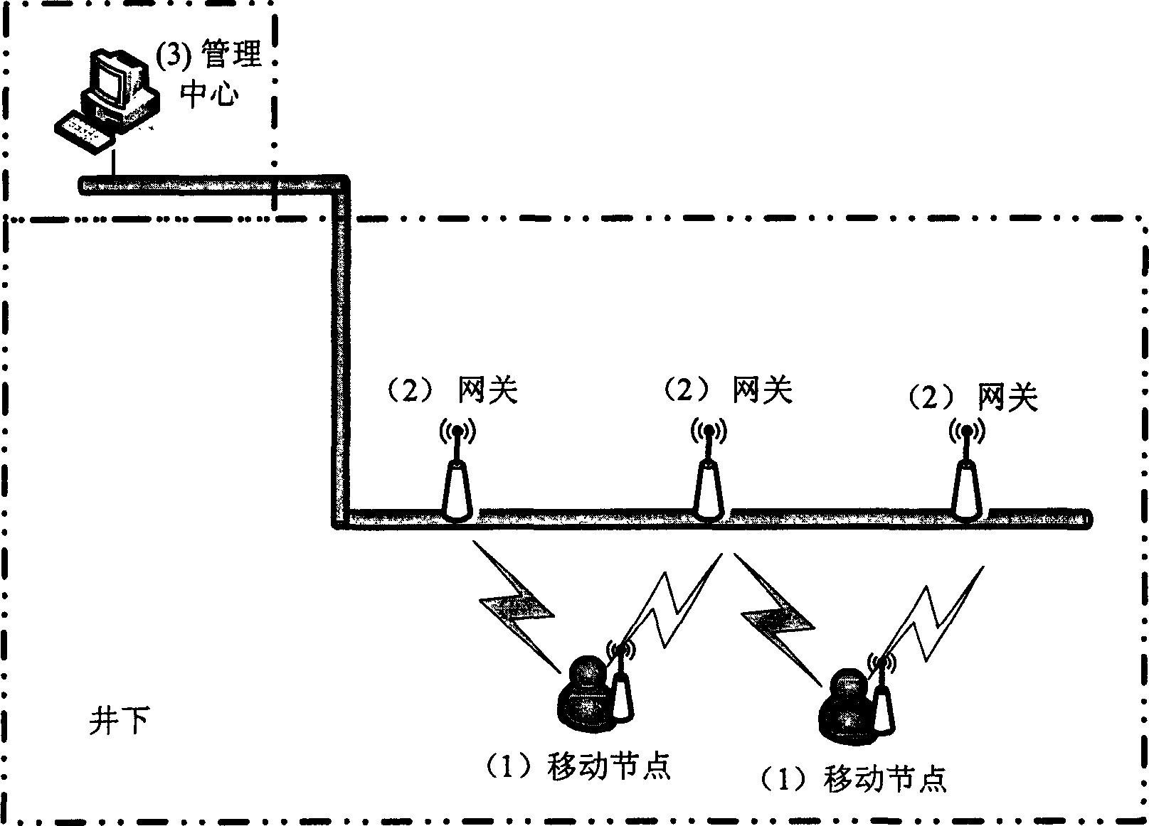
[0015] figure 1 It is a schematic diagram of a downhole positioning system with a sensor network. The system is composed of a mobile node (1), a gateway (2), a wired network and a management center (3). The management center and the gateway are connected through a wired network, and the gateway and the mobile node are connected through wireless communication. The management center is the center of the entire network, including computers, servers, network devices, and management software running on computers and servers. When locating, the management software of the management center sends a locating command at regular intervals, and the command reaches the gateway (2) through the wired network, and the gateway interacts with the mobile node, and the mobile node calculates its position relative to the gateway, and transmits it to the gateway. The gateway adds its own location information and transmits it to the management center, and the management software calculates the dat...


PUM


Abstract

This invention relates to an underground positioning system, device and method based on wireless sensor networks. The system includes: mobile positioning nexuses set in cap-lamps, gateways connecting with wire and wireless networks and a system management center. The method includes: a mobile nexus related position locating method based on RF signal strength, an accurate positioning method combining mobile nexuses and gateways, a method for connecting the ground and underground wire communication system to realize accurate position of mobile persons and equipments.

Description

technical field [0001] The invention relates to the field of mine safety monitoring, in particular to an underground positioning system, device and method based on a wireless sensor network. Background technique [0002] For many years, the underground working environment of the mine has a complex geological environment, various harmful gases, and unknown water bodies escaping. With the advancement of science and technology, various detection systems and monitoring systems have been deployed. However, vicious accidents in mines still continue to occur, seriously threatening the safety of underground workers. However, the mobility of underground operators is high and the working environment is complicated. Once an accident occurs, the exact number of underground personnel and the specific location of each person are difficult to determine, which brings great difficulties to the rescue work, often delays the best time for rescue, and causes serious consequences. In addition...

Claims


Application Information

Patent Timeline
Patent Type & Authority Applications(China)
IPC IPC(8): H04W4/04H04W64/00H04W84/18
Inventor 崔莉苗勇赵泽费璟昊崔洪亮刘巍
Owner INST OF COMPUTING TECH CHINESE ACAD OF SCI
Why Eureka
Try Eureka