Composition of raster and vector graphics in geographical information systems

a technology of geographic information system and vector graphics, applied in the field can solve the problems of destroying the true nature of an image, further challenges, and compositing of vector and raster gis images

Active Publication Date: 2005-12-29
CANVAS GFX LTD
View PDF12 Cites 75 Cited by
  • Summary
  • Abstract
  • Description
  • Claims
  • Application Information

AI Technical Summary

Problems solved by technology

However, up-sampled color values in general are artificial, and often destroy the true nature of an image.
One of the many challenges of image compositing is the overlaying of raster and vector images.
As such, compositing of vector and raster GIS images poses additional aligmnent challenges, beyond those of conventional compositing.
Further challenges arise with editing of such composite vector +raster GIS images.
Conventional digital image applications provide only limited viewing capability for composite vector+raster GIS images, and do not provide editing capability therefor.

Method used


Image

  • Composition of raster and vector graphics in geographical information systems
  • Composition of raster and vector graphics in geographical information systems
  • Composition of raster and vector graphics in geographical information systems

Examples


Embodiment Construction

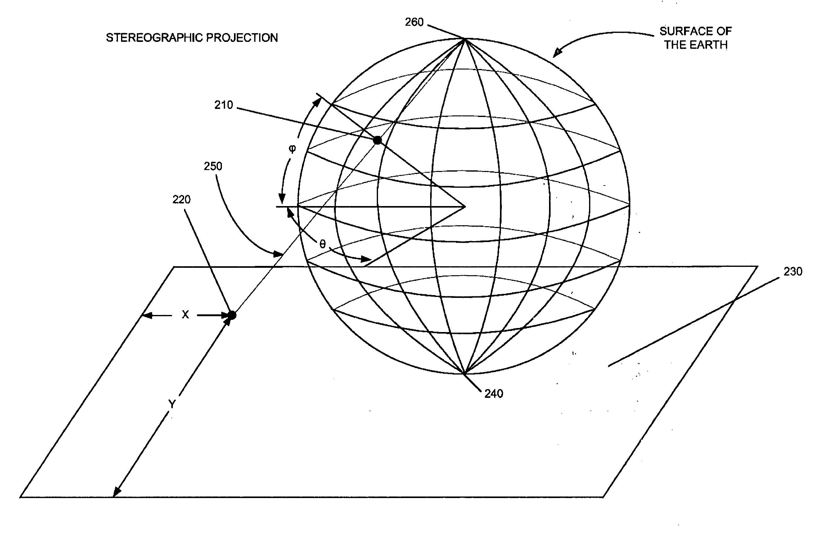
[0042] The present invention concerns composition of vector and raster graphics within geographical information systems (GIS). GIS images are generally of two types: vector images comprised of vector objects such as points, lines and areas, and raster images comprised of arrays of pixel color values.

[0043] The present invention is preferably implemented within a conventional computing device including a central processing unit, memory units for storing programs and data, input devices including a mouse and keyboard, and an output display device. Preferably, the central processing unit, memory units, and device drivers for the mouse, keyboard and display are coupled communicatively together using a conventional data bus. It may be appreciated, however, from the description hereinbelow, that the present invention may also be implemented within non-conventional computing devices, as long as such devices include processing means, program and data storage means, and input and display me...


PUM


Abstract

A method for editing composite geographical images, including importing a raster geographical map file, the raster file including geographical information identifying raster image data, global positioning reference data and a first projection that transforms geographical coordinates to linear coordinates, importing a vector geographical map file, the vector file including geographical information identifying vector objects, rendering a two-dimensional raster image including transforming linear coordinates to geographical coordinates according to the inverse of a prescribed second projection that transforms geographical coordinates to linear coordinates, and re-projecting the geographical coordinates to linear coordinates according to the first projection, rendering a two-dimensional vector image including projecting the vector objects according to the prescribed second projection, compositing the two-dimensional image raster image and the two-dimensional vector image as layers of a composite image, and editing the composite image. A system and a computer readable storage medium are also described and claimed.

Description

FIELD OF THE INVENTION [0001] The present invention relates to geographical information systems (GIS), and in particular to vector and raster GIS images. BACKGROUND OF THE INVENTION [0002] Conventional digital images are represented in either vector or raster formats. Vector formats are used to store lists of vector primitives, which may overlap and obscure or partially obscure one another. The vector primitives themselves generally consist of geometrical primitives including points, curves and areas. Points and curves generally have colors associated therewith, and areas generally have both a fill color and a boundary color. Curves include inter alia lines, pieced together line segments, circles, ellipses and Bezier curves. Graphics software generally provides tools for generating such curves. [0003] Vector primitives are resolution independent, and can be scaled to any desired display screen. Thus a line or a circle, for example, can be rendered within an arbitrary display region ...

Claims


Application Information

Patent Timeline
Patent Type & Authority Applications(United States)
IPC IPC(8): G06T17/05G09G5/00
CPCG06T17/05G06T3/0062
Inventor BALAGA, PIOTRLANDMAN, PHILIP
Owner CANVAS GFX LTD
Why Eureka
Try Eureka