

Using local networks for location information and image tagging
a technology of local area networks and location information, applied in the field of digital image location services, can solve the problems of bulky, inefficient energy consumption, and bulky gps units with handheld digital image capture devices
- Summary
- Abstract
- Description
- Claims
- Application Information
AI Technical Summary
Benefits of technology
Problems solved by technology
Method used
Image

Examples
first embodiment
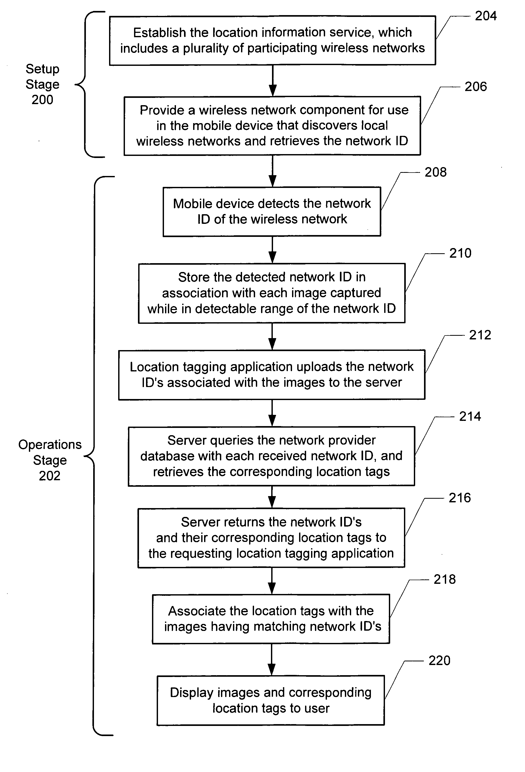
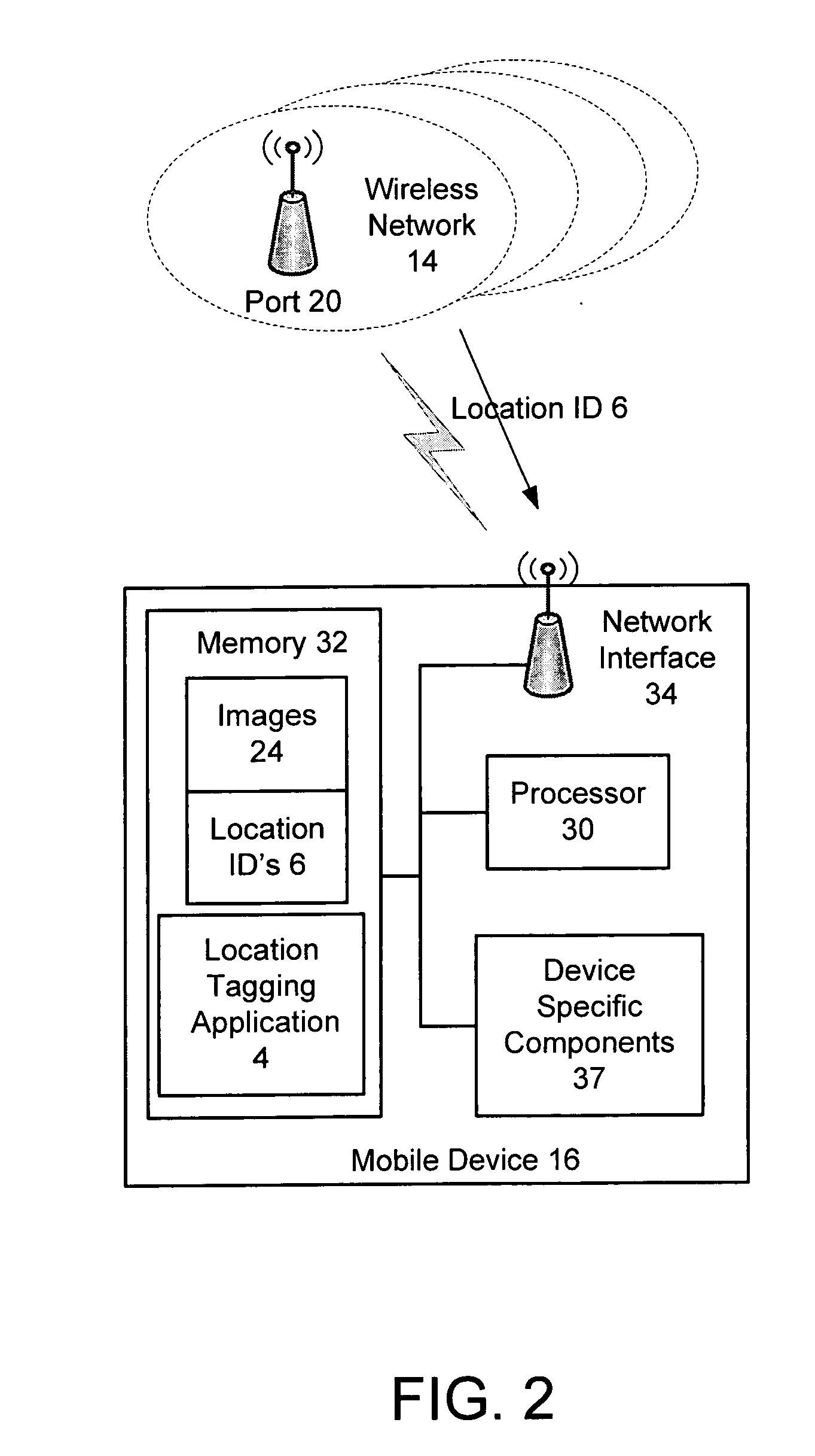
[0021]FIG. 2 is a block diagram illustrating a system for utilizing local networks to determine a location of digital images captured with a mobile device according to the present invention. The system 10 includes a plurality of networks 14 and a hand-held digital image capture device, (hereinafter, mobile device) 16. Although in a preferred embodiment, the network 14 and the mobile device are wireless, as shown, a wired network and wired network connection to the device 16 may also be used to implement the present invention. The wireless networks 14 typically include one or more wireless access ports 20 depending on the geographic size of the network. The geographic boundary covered by each wireless network 14 is commonly referred to as a hot spot. Typically, anyone entering the hot spot with a compliant wireless device has connectivity to the Internet 22. In a preferred embodiment, the wireless networks 14 and the mobile device 16 comply with the IEEE standard 802 and / or BlueTooth...
second embodiment
[0026]FIG. 4 is a block diagram illustrating a system for utilizing local wireless networks to determine a location of digital images captured with a wireless mobile device according to the present invention. The system 10 includes a plurality of wireless networks 14, a mobile device 16, and an optional PC 18 for storing the images captured by the image capture device 14.
[0027] The second embodiment of the present invention also eliminates the need to use GPS systems for location information for images by providing either the mobile device 16 and / or the PC 18 with a location tagging application 36 that may perform the same functions described above for the tagging application, but also communicates with a network-based location information service 12 over the Internet 22. After the mobile device 16 captures digital images 24 while in the presence of the wireless network 14, the user of the mobile device 16 utilizes the location information service 12 to have the captured images 24 a...
third embodiment
[0037] In the present invention, not only does the location information service 12 provide the user with the general capture location tag for each image 24, but also provides a specific description tag that describes the content of the image 24.
[0038]FIG. 7 is a block diagram illustrating a system for providing specific description tags describing the content of digital images, where like components from FIG. 4 have like reference numerals. To implement the third embodiment of the present invention, the location information service 12 is provided with a photographer account database 50, a reference image database 52, and an image recognition application 54.
[0039]FIGS. 8A-8B are flow diagrams illustrating the process of automatically tagging images with location information that includes a description of the image in accordance with a preferred embodiment. The process is similar to that described with respect to FIG. 4 with additional steps. Therefore, FIGS. 6A-6B reproduce the step...
PUM
 Abstract
Description
Claims
Application Information