Navigation service

a technology of navigation service and vehicle, applied in the direction of vehicle position/course/altitude control, process and machine control, instruments, etc., can solve the problems of intermission or even loss of intercompetence between the travelling vehicles, the master vehicle driver travels too fast, etc., to facilitate relaxed driving conditions, shorten the journey time, and minimize the chance of following vehicles being lost

Inactive Publication Date: 2006-07-20
PIECE FUTURE PTE LTD
View PDF44 Cites 145 Cited by
  • Summary
  • Abstract
  • Description
  • Claims
  • Application Information

AI Technical Summary

Problems solved by technology

Due to bad weather conditions, heavy traffic, unforeseen stops, or similar reasons, intervisibility among the travelling vehicles may be intermitted or even lost.
Particularly, this poses a problem in densely populated areas with heavy traffic.
It is possible that the driver of the master vehicle travels too fast because he is so familiar with the traveled road that he does not notice any more the difficulties it poses to the drivers of the slave vehicles.

Method used


Image

  • Navigation service
  • Navigation service
  • Navigation service

Examples


Embodiment Construction

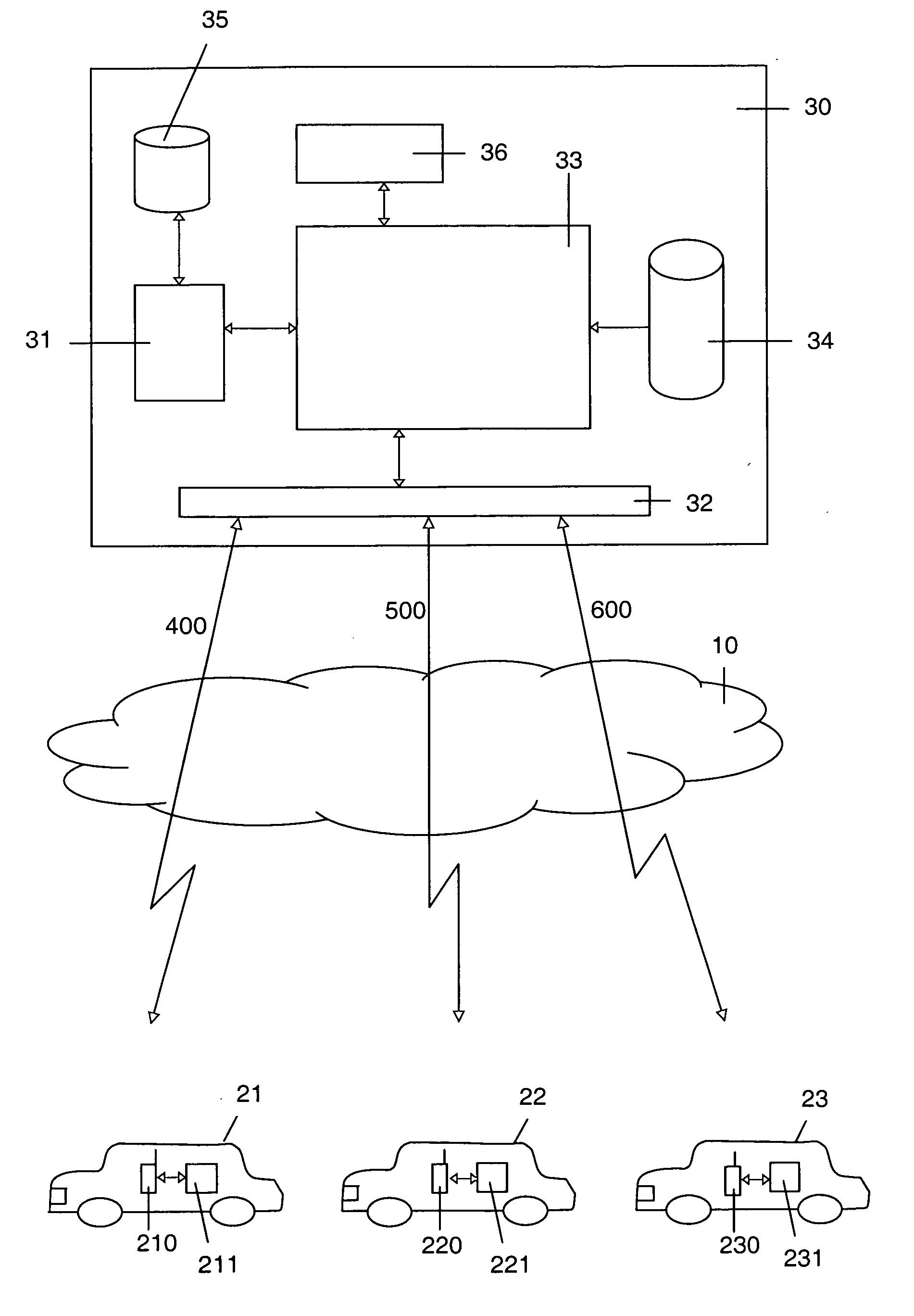
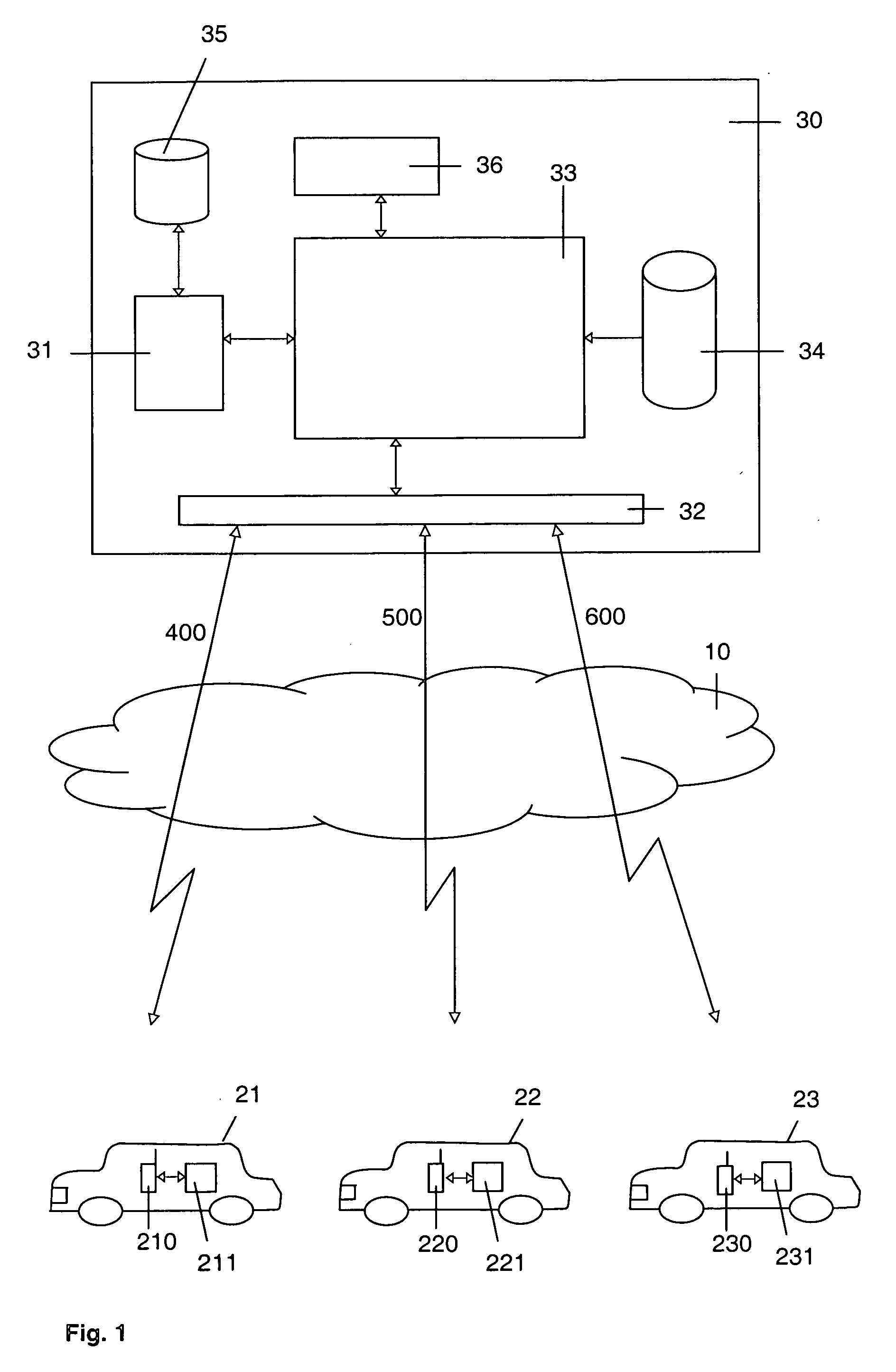
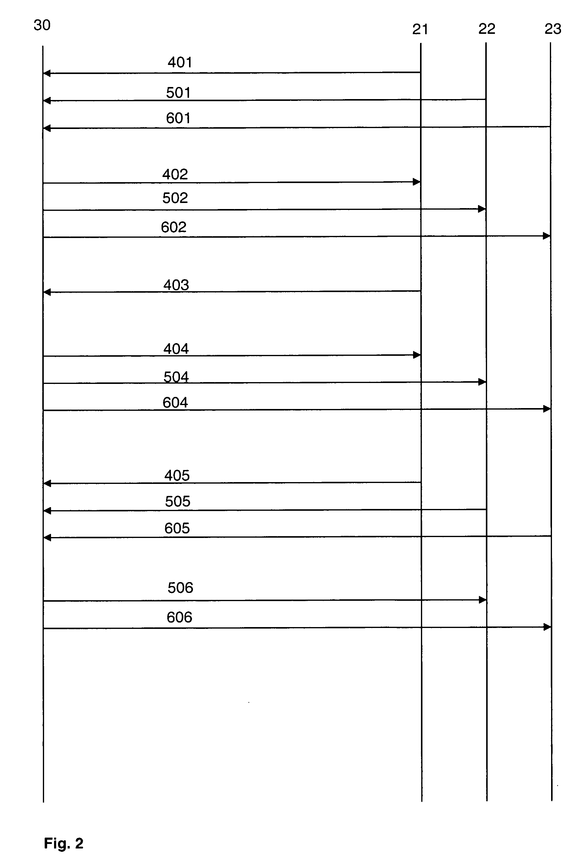
[0030]FIG. 1 is a schematic block diagram of a first embodiment of the present invention.

[0031]FIG. 1 relates to an off-board solution of the navigation service showing three vehicles 21, 22, 23 which meet at a meeting point to form a group and to travel together as a group. Every vehicle 21, 22, 23 comprises a wireless communication unit 210, 220, 230 adapted for use of the navigation service and a navigation unit 211, 221, 231 adapted to receive geographic position data via a positioning system.

[0032] The wireless communication unit 210, 220 and 230 can be any electronic device which is adapted for communicating via a mobile communication network 10, e.g., a cellular communication network as a GSM or UMTS network, and which is adapted to be used in association with a navigation unit 211, 221 or 231. Preferably, it is a convenient mobile telephone, e.g., a Java-enabled cellular phone, but it can also be any other suitable device like, e.g., a PDA or a notebook with wireless commu...


PUM


Abstract

A group of two or more vehicles (21, 22, 23), each vehicle (21, 22, 23) comprising a communication unit (210, 220, 230) coupled with a navigation unit (211, 221, 231), wherein one vehicle of the group is classified as master vehicle (21) leading the group and the remaining vehicles of the group are classified as slave vehicles (22, 23) following the master vehicle (21), travel together. A central remote navigation server (30) provides the vehicles (21, 22, 23) with a navigation service, wherein the navigation server (30) calculates for each of the slave vehicles (22, 23) route instructions (506, 606) such that the slave vehicles (22, 23) are instructed to follow the master vehicle (21). The route instructions (506, 606) are transmitted to the slave vehicles (22, 23) via a communication network (10).

Description

[0001] The invention is based on a priority application EP 05290088.3 which is hereby incorporated by reference. FIELD OF THE INVENTION [0002] The invention relates to a method for providing vehicles with a navigation service as well as a navigation server and a navigation system for executing the method. BACKGROUND OF THE INVENTION [0003] The availability of exact navigation means like, e.g., GPS, to common transport vehicles, for example cars, has greatly facilitated route navigation (GPS=Global Positioning System). The driver of a vehicle no longer has to look for his way in paper road maps. Instead he is conveniently guided by visual and / or accoustic path information offered via an electronic navigation system. [0004] Basically, navigation systems can be distinguished between on-board and off-board systems. On-board navigation devices are stand-alone devices which hold a road map database of a preferred travel area (usually stored on an exchangeable data carrier like,. e.g., CD-...

Claims


Application Information

Patent Timeline
Patent Type & Authority Applications(United States)
IPC IPC(8): G01C21/30
CPCG08G1/20G05D2201/0213G05D1/0295G08G1/22
Inventor HAEGEBARTH, FRANKLOSCH, KURT
Owner PIECE FUTURE PTE LTD
Why Eureka
Try Eureka