GPS device and method for layered display of elements

a layered display and element technology, applied in surveying and navigation, navigation instruments, instruments, etc., can solve the problems of reducing the user's appreciation of the total information content of maps, introducing a substantial degree of inconvenience and inefficiency, and reducing the overall benefit of maps. , to achieve the effect of maximizing the total benefit from and usability of various elements and minimizing interferen

Inactive Publication Date: 2006-08-24
BUSHNELL
View PDF12 Cites 5 Cited by
  • Summary
  • Abstract
  • Description
  • Claims
  • Application Information

AI Technical Summary

Benefits of technology

[0008] The present invention overcomes the above-described and other disadvantages in the prior art by providing a GPS device and method for conditioning and hierarchically layering or ordering a plurality of static or dynamic image, information, tool, control, or other elements for simultaneous display in such a way as to minimize interference and maximize total benefit from and usability of the various elements.

Problems solved by technology

Unfortunately, these different maps are not simultaneously viewable by the user.
Instead, the user must toggle the display from one map to the other, or otherwise separately display the maps, which can both cause disorientation and create an artificial disconnect that reduces the user's appreciation of the total information content of the maps.
Unfortunately, when the user toggles to a different map or image the geo-referenced information does not follow.
At best, the user may be able to display a separate instance of the geo-referenced information in association with each map or other image which the user desires to view, which introduces a substantial degree of inconvenience and inefficiency.
Additionally, some such prior art GPS devices require considerable user interaction to set-up or otherwise prepare for use, including creating the aforementioned geo-referenced information.
This process can be very time consuming and even intimidating.

Method used


Image

  • GPS device and method for layered display of elements
  • GPS device and method for layered display of elements
  • GPS device and method for layered display of elements

Examples


Embodiment Construction

, below.

BRIEF DESCRIPTION OF THE DRAWINGS

[0013] A preferred embodiment of the present invention is described in detail below with reference to the attached drawing figures, wherein:

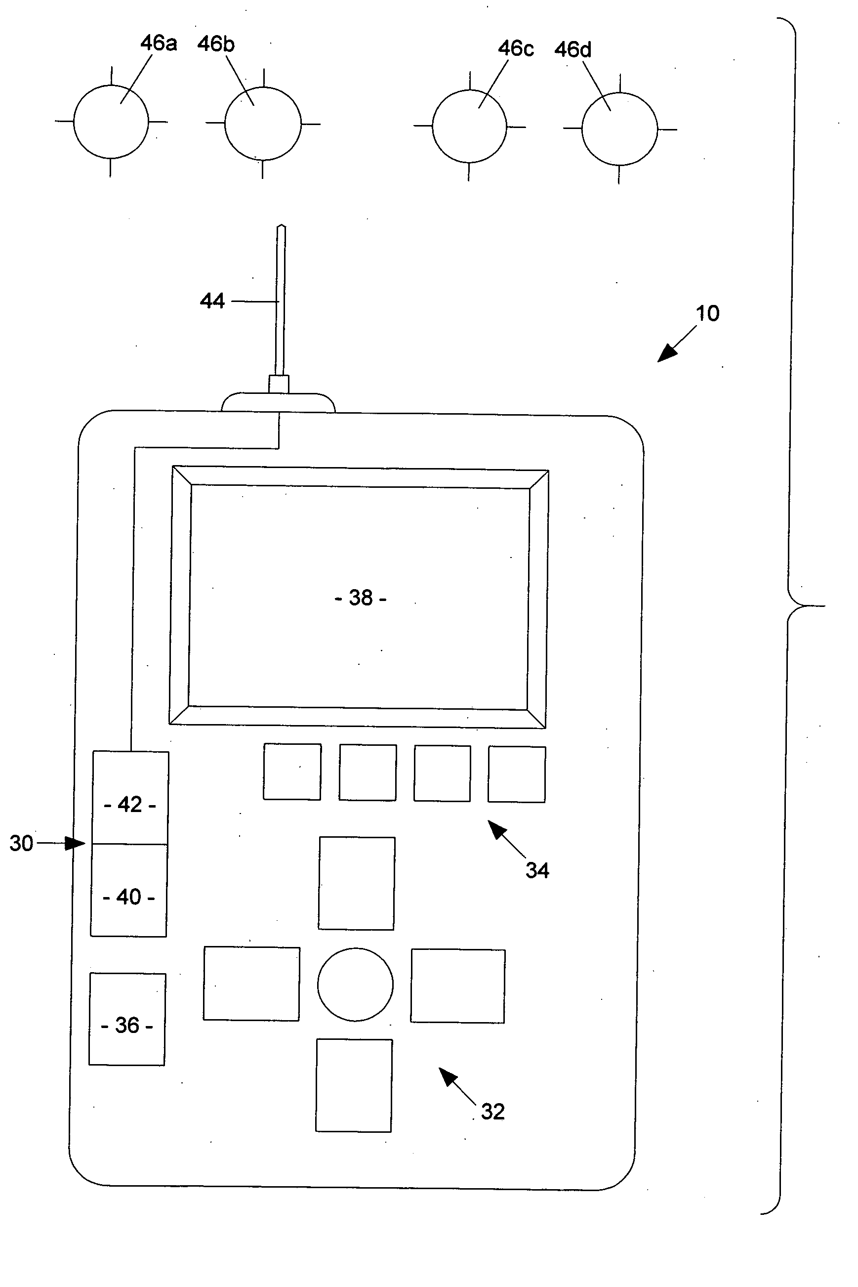
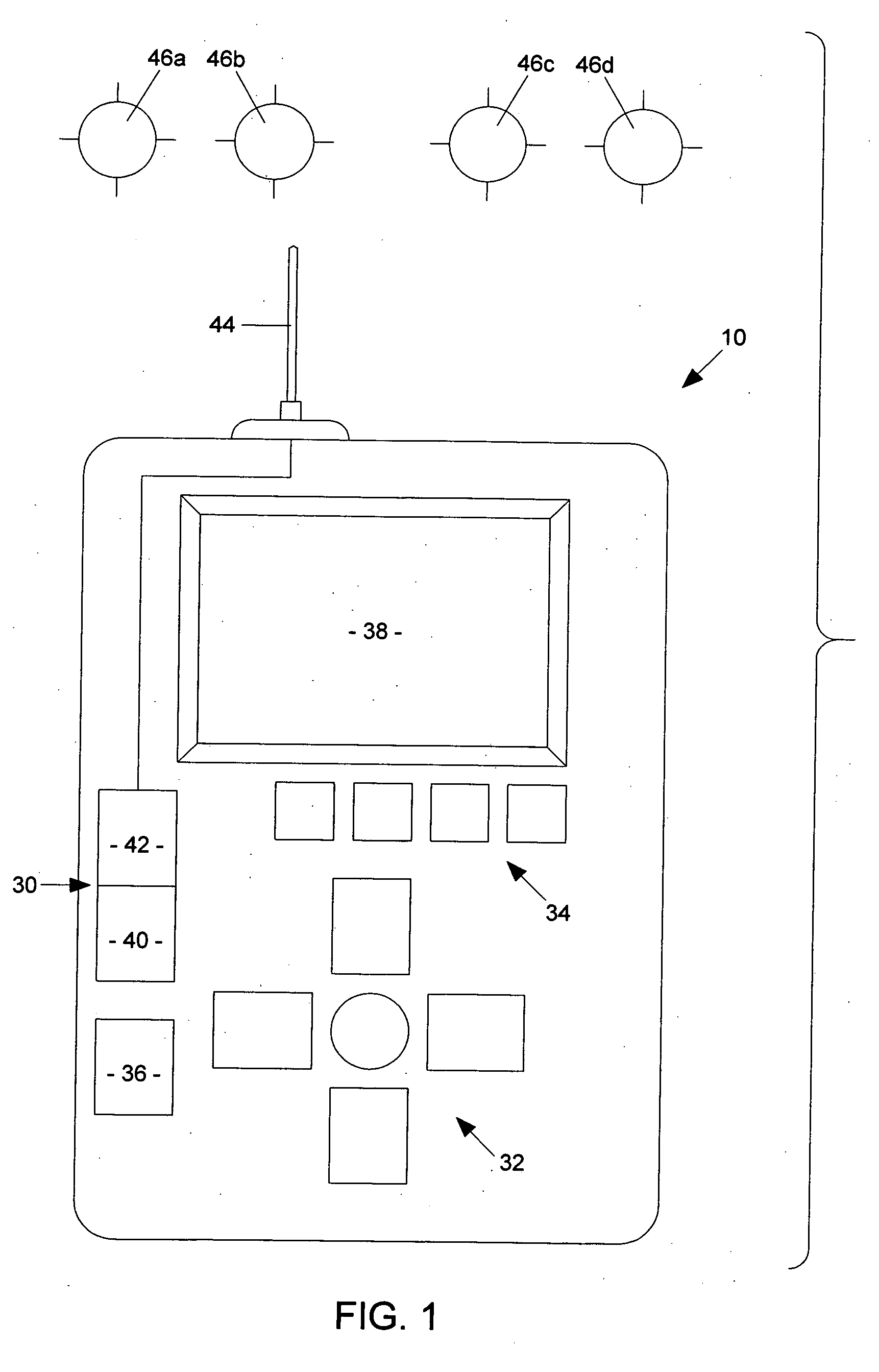
[0014]FIG. 1 is a block-diagram depiction of a preferred embodiment of a GPS device of the present invention;

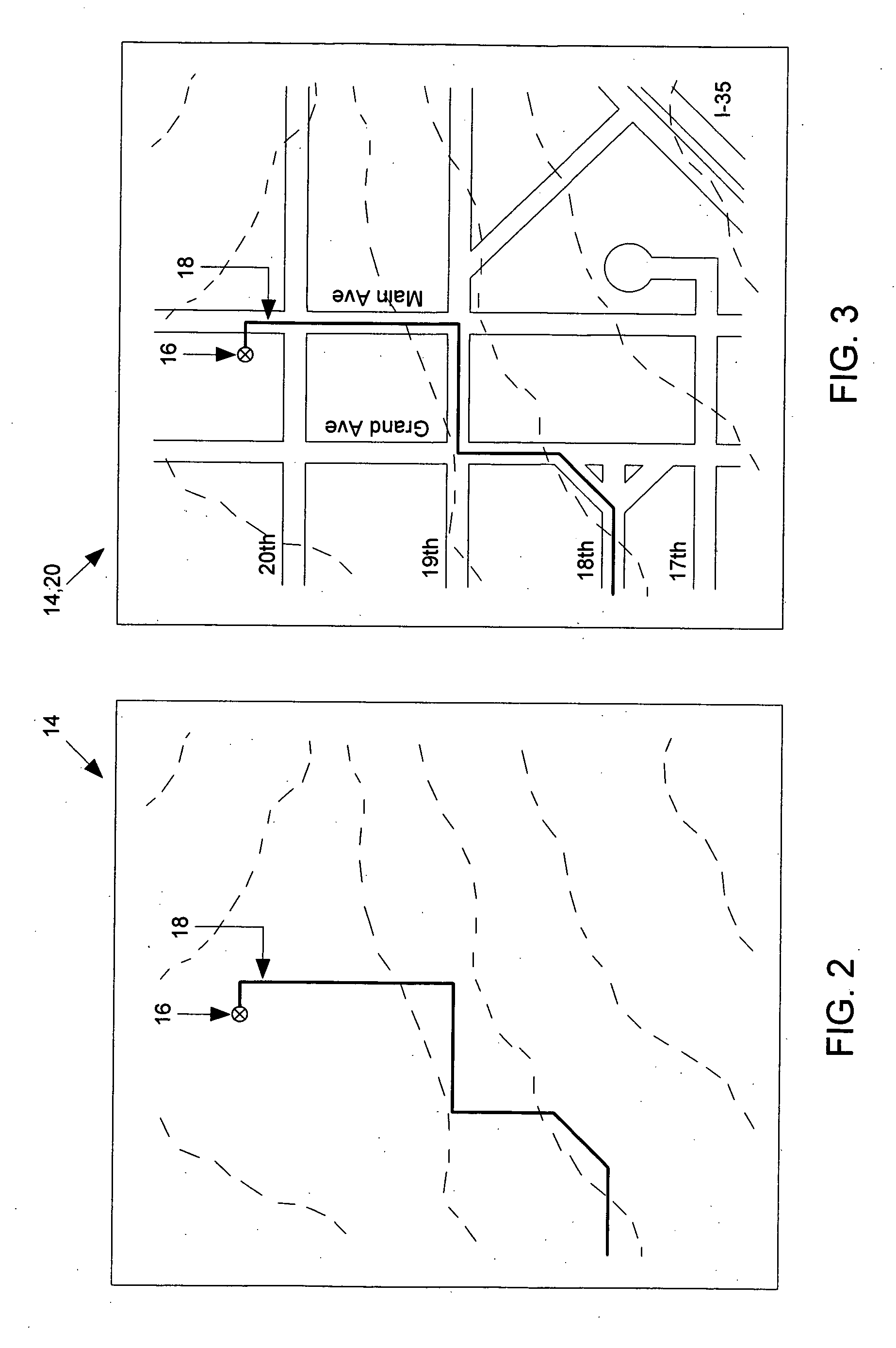
[0015]FIG. 2 is a depiction of a topographical map showing elevation or contour lines, wherein the topographical map is displayed on the GPS device of FIG. 1 simultaneously with and under geo-referenced information in the form of a waypoint and a trail;

[0016]FIG. 3 is a depiction of a street map displayed simultaneously with and over the topographical map of FIG. 2;

[0017]FIG. 4 is a depiction of an aerial photograph displayed simultaneously with and under both the topographical map of FIG. 2 and the street map of FIG. 3;

[0018]FIG. 5 is a depiction of a virtual compass displayed simultaneously with and over all of the topographical map of FIG. 2, the street map of FIG. 3, and the aerial photog...


PUM


Abstract

A GPS device and method for conditioning and hierarchically layering or ordering a plurality of static or dynamic image, information, tool, control, or other elements for simultaneous display in such a way as to minimize interference and maximize total benefit from and usability of the various elements.

Description

BACKGROUND OF THE INVENTION [0001] 1. Field of the Invention [0002] The present invention relates broadly to hand-held electronic GPS-based navigation aids and related methods for facilitating navigation. More particularly, the present invention concerns a GPS device and method for conditioning and hierarchically layering or ordering a plurality of static or dynamic image, information, tool, control, or other elements for simultaneous display in such a way as to minimize interference and maximize total benefit from and usability of the various elements. [0003] 2. Description of the Prior Art [0004] Outdoor enthusiasts, such as sportsmen, vacationers, and athletes, increasingly use hand-held electronic global positioning system (GPS) devices to navigate while afield. Commonly-available GPS devices typically include at least a processor, a receiver, and an antenna for receiving position signals from a plurality of known locations (e.g., from satellites in orbit) and, through a process...

Claims


Application Information

Patent Timeline
Patent Type & Authority Applications(United States)
IPC IPC(8): G01C21/36
CPCG01C21/36
Inventor CROSS, JOHNLALIK, CHRISTOPHERDECASTRO, JOHNBALL, RICHARD
Owner BUSHNELL
Why Eureka
Try Eureka