Method for providing terrain alerts and display utilizing temperature compensated and GPS altitude data

a technology of altitude data and terrain alerts, applied in the field of avionics, can solve problems such as inaccurate altimeter setting, adc sensor errors or errors, and inability to correct for the effect of non-standard altitude above field elevations, and achieve accurate terrain depiction

Active Publication Date: 2006-11-02
UNIVERSAL AVIONICS SYST
View PDF3 Cites 29 Cited by
  • Summary
  • Abstract
  • Description
  • Claims
  • Application Information

AI Technical Summary

Benefits of technology

[0010] The present invention is directed to an avionics system comprising a method that accounts for altitude reporting errors due to ADC sensor errors, incorrectly set altimeters or non-standard atmospheric conditions and provides accurate alerting despite the errors. The present invention provides an accurate depiction of terrain relative to an aircraft even in cases where an incorrect altimeter setting, sensor error and non-standard atmospheric conditions exist. The present invention accomplishes this objective by employing a method that:

Problems solved by technology

Conventional systems do not take into account errors arising from incorrectly set altimeters, ADC sensor errors or errors due to non standard atmospheric conditions (on cold days).
Any deviation from ISA conditions may result in an erroneous reading on the altimeter.
The local altimeter setting provides the necessary correction for the non-standard pressure in the local area but it does not correct for the effect of non-standard temperatures for altitudes above field elevations.
The altimeter error is relatively minor down to 0° C. but it can be significant with the minimum altitudes required on some approaches to airports in mountainous areas.
Moreover, in the context of TAWS, altimeter error due to temperature can cause false alarms or no alarm when one is needed.

Method used


Image

  • Method for providing terrain alerts and display utilizing temperature compensated and GPS altitude data
  • Method for providing terrain alerts and display utilizing temperature compensated and GPS altitude data
  • Method for providing terrain alerts and display utilizing temperature compensated and GPS altitude data

Examples


Embodiment Construction

[0030] Reference will now be made in detail to the preferred embodiments of the present invention, examples of which are illustrated in the accompanying drawings.

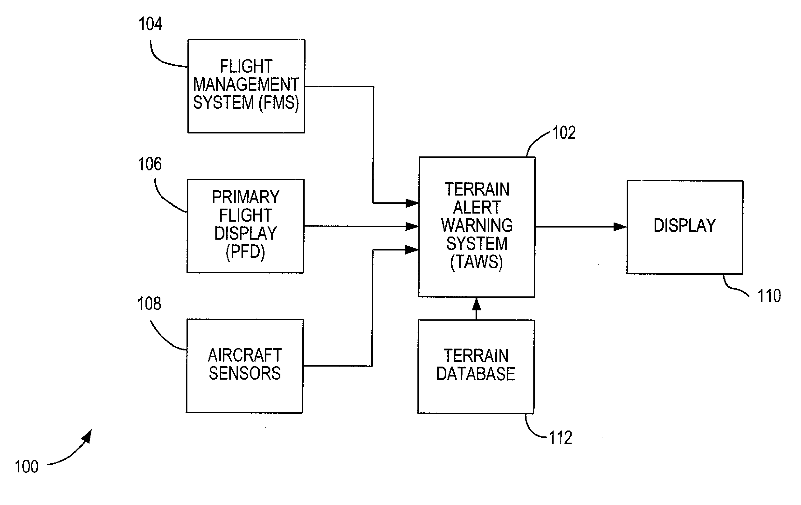
[0031] The present invention comprises improvements to conventional avionics systems including a TAWS disclosed in commonly assigned U.S. Pat. No. 6,643,580 entitled Flight Plan Intent Alert System and Method, which specification is hereby incorporated by reference. The present invention provides a method for overcoming altitude reporting errors in an avionics system that arise from incorrect altimeter setting, Air Data Computer (ADC) sensor error or altimeter error due to non-standard atmospheric conditions such as deviations from International Standard Atmosphere (ISA) conditions. When ISA conditions are not present, the altitude reading from an altimeter or ADC may not be accurate. In ISA+ conditions (temperature above ISA), an aircraft is higher than the reading on the altimeter. Conversely, in ISA− conditions (tempera...


PUM


Abstract

A method of accounting for errors in the altitude reporting of a terrain alert and warning system (TAWS) is disclosed wherein errors due to non-standard atmospheric conditions, incorrect altimeter setting and air data computer (ADC) sensor error are detected and corrected for by compensating ADC altitudes for cold temperatures as well as using global positioning system (GPS) altitude data to confirm the accuracy of the ADC altitude information at all times.

Description

[0001] This application claims the benefit of Provisional Application Ser. No. 60 / 610,606 filed Sep. 17, 2004.{grave over (1)}FIELD OF THE INVENTION [0002] The present invention relates to the field of avionics. More specifically, this invention relates to a method for providing accurate terrain alerts and warnings utilizing flight plan information. BACKGROUND OF THE INVENTION [0003] Current aircraft avionics systems including Terrain Alert and Warning Systems (TAWS) accept flight plan information and use this information in the piloting of aircraft. Flight plan information is provided as a series of waypoints having attributes including latitude, longitude, altitude constraints and waypoint identifiers. A flight plan defined by this information is modeled by the system, and the flight plan model is checked against terrain information to locate any instances in which a potentially unsafe flight altitude exists. In flight, the flight path model is updated using aircraft position so t...

Claims


Application Information

Patent Timeline
Patent Type & Authority Applications(United States)
IPC IPC(8): G01C23/00
CPCG01C23/00G01C5/005
Inventor ARDILA, RICARDOFARNHAM, DEAN L.FENG, NICKFERGUSON, ROBERT SCOTTKROHN, PATRICK GERALDMOSS, STEVEN J.
Owner UNIVERSAL AVIONICS SYST
Why Eureka
Try Eureka