Triangulation method and apparatus for targeting and accessing spatially associated information

a technology of spatially associated information and triangulation method, which is applied in the direction of distance measurement, navigation instruments, instruments, etc., can solve the problems of not being able to and not being able to keep printed information up to date, etc., to achieve accurate identification of the distant location, reduce the amount of information, and accurately identify the distant location

Inactive Publication Date: 2006-11-16
OUTLAND RES
View PDF99 Cites 92 Cited by
  • Summary
  • Abstract
  • Description
  • Claims
  • Application Information

AI Technical Summary

Benefits of technology

[0020] The method consists of a multi-step triangulation process to more accurately identify the distant location for which information is to be retrieved. One embodiment of the multi-step triangulation process involves targeting the distant location a plurality of times each time from separate position within the physical environment. Each time the distant location is targeted from a separate position within the physical environment, a positional coordinate and directional vector are collected that describe the aiming position and aiming orientation of the handheld computing device for that targeting step. A plurality of such positional coordinates and directional vectors are used in combination to more accurately identify the distant location for which information is be retrieved. The retrieved information is then displayed upon the screen of the handheld device.
[0021] This method can be used in combination with object type and / or object context type filters to reduce the amount of information and / or to more accurately specify the information that is to be retrieved and / or displayed. Furthermore the portable computer may incorporate one or more targeting components for aiding the user in targeting the distant location. One such targeting component is a laser pointer. Another such targeting component is a camera.

Problems solved by technology

The problem with such systems is that a user often wants to gain information about a location that they are not local to, but which is off in the viewable distance to that user.
However, these documents are not very informative because they contain limited amounts of information and are generally not useful on the fine identification of objects such as specific trees and plants.
Also such printed information is generally not kept up to date as well as on-line information.
In addition, such information is not always easy to relate to the real physical surroundings in which a user is located.
The user may find it difficult to know which of numerous trees located in that general direction the field guide is referring to.
Another problem with printed field guides and brochures is that they are difficult to update, providing information that may be old or incomplete.
In addition, users can take their own personal notes on field guides and brochures to note changes or make additional comments, but such notes can not be easily shared among other users.
This lack of information and / or difficulty in updating information often results in ineffective advertising for businesses and limited scientific information about natural phenomenon.
For example, on a traditional map or brochure covering a city, business are not be able to provide the consumer with a list of products sold in a particular store nor can businesses indicate products that are currently on sale or otherwise featured.
Similarly, a local historical building may not be able to provide the public with detailed historical information concerning the significance of the site or any new information such as upcoming events at that location.
However, a user will not have access to the desired information unless they manually input a web address or uniform resource locator (URL) associated with a particular web page.
In these cases, it may be difficult to retrieve the web page because the URL may be unknown or difficult to locate, even with the sophisticated search engines currently available.
Also, the web address may be very long which may result in a mistake when entering the web address.
In such a circumstance the user may not know how to search for a URL that would provide information about the particular tree or building or river or lake or hill or rock other object that they are then looking at and wondering about.

Method used


Image

  • Triangulation method and apparatus for targeting and accessing spatially associated information
  • Triangulation method and apparatus for targeting and accessing spatially associated information
  • Triangulation method and apparatus for targeting and accessing spatially associated information

Examples


Embodiment Construction

[0027] The following description is not to be taken in a limiting sense, but is made merely for the purpose of describing the general principles of exemplary embodiments. The scope of the invention should be determined with reference to the claims.

Operational Overview

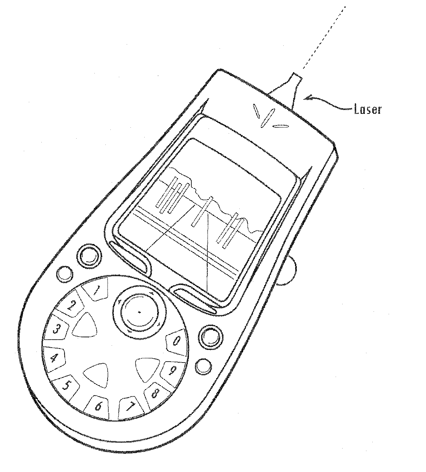
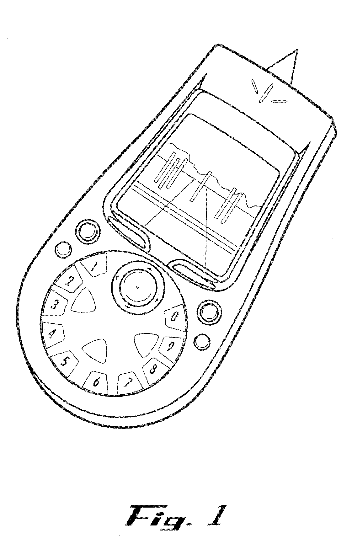
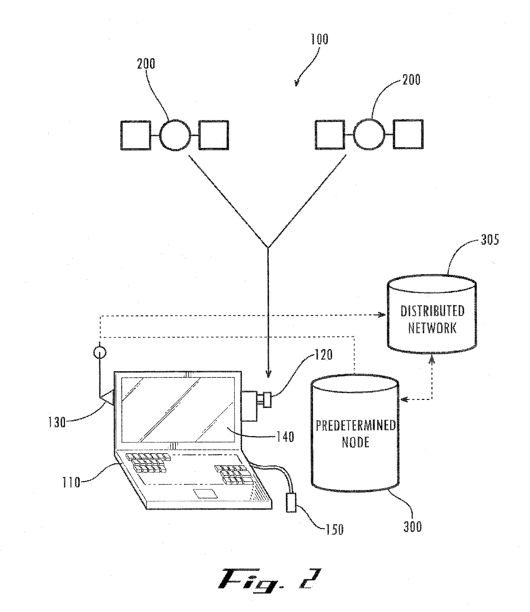
[0028] The present embodiments enable a user to access information associated with a distant spatial location (or a distant spatial area) by pointing a handheld computing device at that distant location (or distant area) from a plurality of different local locations. As used herein, the term “distant location” refers to a spatial location within the user's environment that is located some distance away from the place that the user is standing. In practical terms, a distant location is a location that is far enough away from the user or inconvenient enough to access that it does not make sense for the user to simply walk over and hold the personal computing device at or near that location. Similarly, as used herein, t...


PUM


Abstract

A method and apparatus is disclosed for enabling a user to target and access information that is associated with physical locations that are spatially distant from said user. More specifically, a method and apparatus is disclosed herein for enabling enhanced accuracy of spatial targeting and information access through a multi-step triangulation process. The methods and apparatus disclosed herein relate to portable information-targeting and information-accessing systems, such as a portable computing device interfaced with a positioning system such as the civilian Navstar Global Positioning System (GPS) in combination with a distributed network.

Description

[0001] This application claims, under 35 U.S.C. § 119(e), the benefit of U.S. Provisional Application No. 60 / 707,909, entitled METHOD AND APPARATUS FOR ACCESSING OF DISTANT SPATIALLY-ASSOCIATED INFORMATION, filed Aug. 12, 2005, (Attorney Docket No 3502.021) by Rosenberg, which is incorporated in its entirety herein by reference. [0002] This application is a continuation in part, under 35 U.S.C. § 120, of U.S. patent application Ser. No. 11 / 315,755 (Attorney Docket No 3502.016), entitled METHOD AND APPARATUS FOR ACCESSING SPATIALLY ASSOCIATED INFORMATION as filed Dec. 21, 2005, by Rosenberg, which also claims benefit under 35 U.S.C. § 119(e) to U.S. Provisional Application No. 60 / 680,699, entitled DATASCOPE INTERFACE FOR ACCESSING DISTANT SPATIALLY ASSOCIATED INFORMATION, filed May 13, 2005, (Attorney Docket No 3502.015) by Rosenberg, which are incorporated in their entirety by reference.CROSS REFERENCE TO RELATED APPLICATIONS [0003] None FEDERALLY SPONSORED RESEARCH [0004] None BACK...

Claims


Application Information

Patent Timeline
Patent Type & Authority Applications(United States)
IPC IPC(8): G01S5/14G01C21/32G01S3/02G08B1/08G01S19/03G01S19/21
CPCG01C3/18G01C21/20G01S19/14G01S19/51
Inventor ROSENBERG, LOUIS
Owner OUTLAND RES
Why Eureka
Try Eureka