Method for geocoding a perspective image

a perspective image and image technology, applied in the field of geocoding a perspective image, can solve the problems of insufficient accuracy of the on-board sensor, difficult and expensive, and insufficient information for two-dimensional perspective image reconstruction,

Active Publication Date: 2007-01-04
THE BOEING CO
View PDF17 Cites 38 Cited by
  • Summary
  • Abstract
  • Description
  • Claims
  • Application Information

AI Technical Summary

Benefits of technology

[0026] It is typical that, in using a forward perspective transform, not all of the perspective geocoordinate array elements will be mapped with a reference elevation array element. Unmapped perspective geocoordinate array elements in the rows and columns of the perspective geocoordinate array are identified each time a reference elevation array element is mapped into a perspective geocoordinate array element. Any unmapped perspective geocoordinate array elements in the column below the mapped perspective geocoordinate array element are then backfilled with the geocoordinate value of the mapped perspective geocoordinate array element above them in the column. In addition, unmapped perspective geocoordinate array elements in a row having adjacent mapped or backfilled perspective geocoordinate array elements in the same row on opposite sides of the unmapped perspective geocoordinate array element are backfilled with an interpolation of the geocoordinate value of the adjacent mapped perspective geocoordinate array elements. The novel backfilling of the perspective geocoordinate array elements fills (as needed) the unassigned geocoordinate array elements in the perspective geocoordinate array, resulting in a complete geocoding for the perspective image of the sensed location.

Problems solved by technology

However, making an on-board sensor highly accurate, so that targets can be located within a ground coordinate system with sufficient accuracy using the image produced by the sensor, is difficult and expensive.
While each pixel in the perspective image depicts the scene content at a single location in the scene area, the projection means discards one dimension of information as it operates, and a two dimensional perspective image does not contain enough information to reconstruct the three dimensional information.
It is not possible, however, to identify a single, specific point on that line to be identified as the scene location which is depicted in that pixel.
Using an auxiliary three dimensional model of the scene area, it is possible to determine the three dimensional points associated with the pixels in a two dimensional perspective image, although the process has been difficult and slow.
This intersection is an extremely difficult process, as it must account for multiple possible intersections of each ray with the three dimensional elevation model or scene model.
A typical facet model may contain millions of facets, so the search with each ray for facet intersections is very expensive.
A similar difficulty occurs with a volume model of the scene, and the volume model may first have to be reduced to a collection of surface facets which are then treated as a facet model of the scene area.
The OpenGL projection model is computationally demanding.
This leads to a requirement for a major computational effort, normally provided by implementing OpenGL in a specialized hardware graphics adaptor.
There are many applications where use of the OpenGL projection model, or an OpenGL hardware graphics accelerator, or even an OpenGL software simulation are not possible, or not desirable.
Applications that require small computers, such as a wearable computer, or computers in specialized environments, such as in fighter aircraft equipment bays or on Space Shuttle robot arms, are particular examples where a standard graphics capability may not be feasible to implement.
Electrical power requirements may prevent use of a graphics adaptor, because of their usually large power and heat demands, arising from the high-speed processors they employ.

Method used


Image

  • Method for geocoding a perspective image
  • Method for geocoding a perspective image
  • Method for geocoding a perspective image

Examples


Embodiment Construction

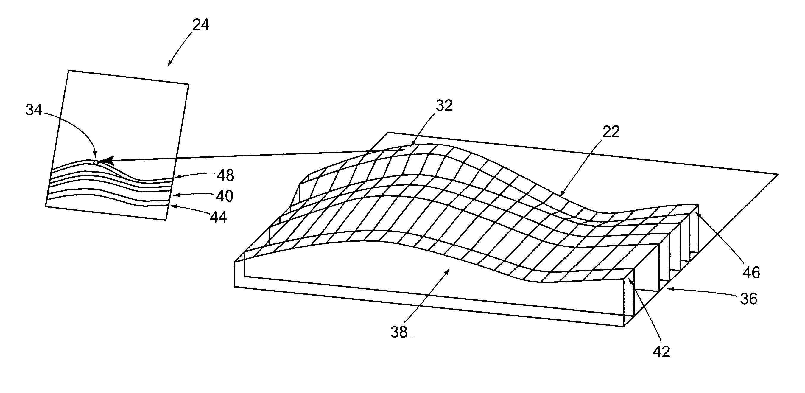
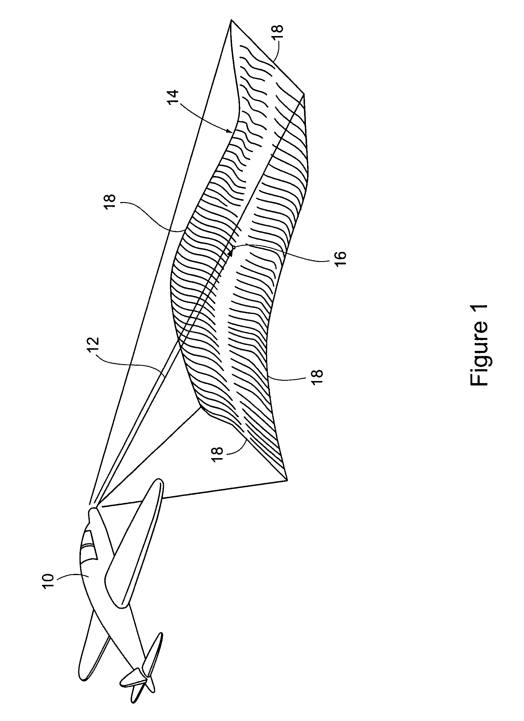
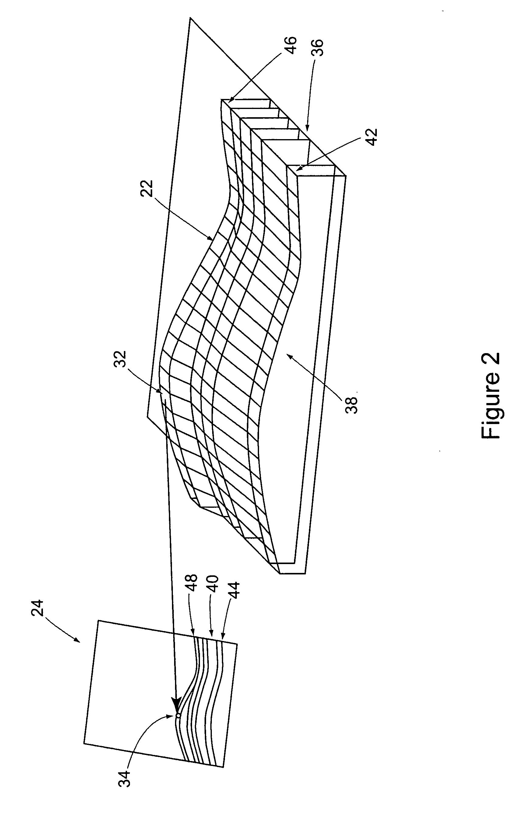
[0034] In a preferred embodiment, the invention provides a method of generating a perspective geocoordinate array for a location from a reference elevation array of the location, where the generated perspective geocoordinate array is recorded as a numerical array of electronically stored values for additional processing, or for storage in a computer file for later use. The description of the method to follow is made with reference to its use in a military aircraft, where the method generates a perspective geocoordinate array for a geographic target area. However, it should be understood that the method of the invention has many different applications, for example, for generating a perspective model coordinate array for a location to be used by a robot to enable movement of the robot around obstacles at the given location. In another example, the method of the invention may be employed in generating a perspective scene coordinate array of a location where a remotely-operated mechanic...


PUM


Abstract

A method for geographically registering a perspective image of a location assigns elevation values to elements or pixels of a two dimensional array of image elements or pixels of the location. The elevation value for each image pixel is obtained using a corresponding database stored reference digital elevation model, or a three dimensional surface model of the location. The reference elevation model or surface model is composed of rows and columns of elevation values corresponding to two dimensions of location values at a sensed location shown in the image, or is composed of a three dimensional surface or volume model of the location, such as a computer-aided design model or any other means of describing the three dimensional characteristics of the sensed location.

Description

[0001] This patent application is a continuation-in-part of application Ser. No. 11 / 174,036, which was filed on Jul. 1, 2005 and is currently pending. The parent application is assigned to the assignee of this application and is incorporated herein by reference.BACKGROUND OF THE INVENTION [0002] (1) Field of the Invention [0003] The present invention pertains to a method of geocoding a perspective image comprised of a two dimensional array of picture elements or pixels, so that each picture element or pixel of the perspective image has associated with it a unique, three dimensional geographic location in the scene depicted by the perspective image. The three dimensional location at each pixel is obtained using a corresponding database stored reference digital elevation model, or a three dimensional surface model of the location. The reference elevation model or surface model may be composed of rows and columns of height values corresponding to two dimensions of location values in th...

Claims


Application Information

Patent Timeline
Patent Type & Authority Applications(United States)
IPC IPC(8): G06T15/00
CPCG01C11/00H04N2201/3253G06T17/05
Inventor OLDROYD, LAWRENCE
Owner THE BOEING CO
Why Eureka
Try Eureka