Underwater geopositioning methods and apparatus

a geopositioning method and underwater technology, applied in direction/deviation determination systems, instruments, using reradiation, etc., can solve the problems of increasing the need for navigational assistance beneath the water, affecting the operation of the system, and reducing the visibility of the system components. , to achieve the effect of eliminating the above-water visibility of the system components

Active Publication Date: 2007-02-01
TELEDYNE INSTR INC
View PDF6 Cites 37 Cited by
  • Summary
  • Abstract
  • Description
  • Claims
  • Application Information

AI Technical Summary

Benefits of technology

[0011] It is an additional object of the invention to eliminate above-water visibility of system components while determining the geophysical and depth positions of autonomous underwater systems employing acoustic modems.

Problems solved by technology

The need for navigational assistance beneath the water is further exacerbated by the general lack of available visible references.
The navigation technologies available today for unmanned undersea vehicles (Mobiles) are expensive and operationally limiting.
These systems, however, generally have very limited depth capability (30 meters below the vehicle is typical); 2) Long baseline (LBL), another technique which operates by relying on a series of fixed underwater transponder beacons.
This technique offers precision, but requires extensive preparation and surface expression by the deploying asset (e.g., a small craft)—a factor of importance in military applications; 3) inertial navigation, a complex and costly technique which relies on precise measurement of acceleration and rotation of the autonomous system and typically has a drift rate on the order of 1 nm / hour without compensation from a DVL or LBL; and 4) GPS surface fix, which places limitations on sea state capability and which offers precision dependent on the amount of time spent on the surface.
Of these four, the LBL system is the least intrusive on, and least expensive for the vehicle, but deploying enough acoustic sources to cover a significant area (say, 5 km by 5 km) is problematic and expensive in terms of the time of the deployment vessel.
However, the relationship is parameterized on water temperature and salinity, which are often difficult to measure.
This system, however, relies on a costly and inconvenient apparatus of multiple above water nodes.
Present technology adopting this method is prone to many of the drawbacks of LBL in that pre-programmed information about fixed geophysical positions and depths must be coordinated prior to deployment of the system.

Method used


Image

  • Underwater geopositioning methods and apparatus
  • Underwater geopositioning methods and apparatus
  • Underwater geopositioning methods and apparatus

Examples


Embodiment Construction

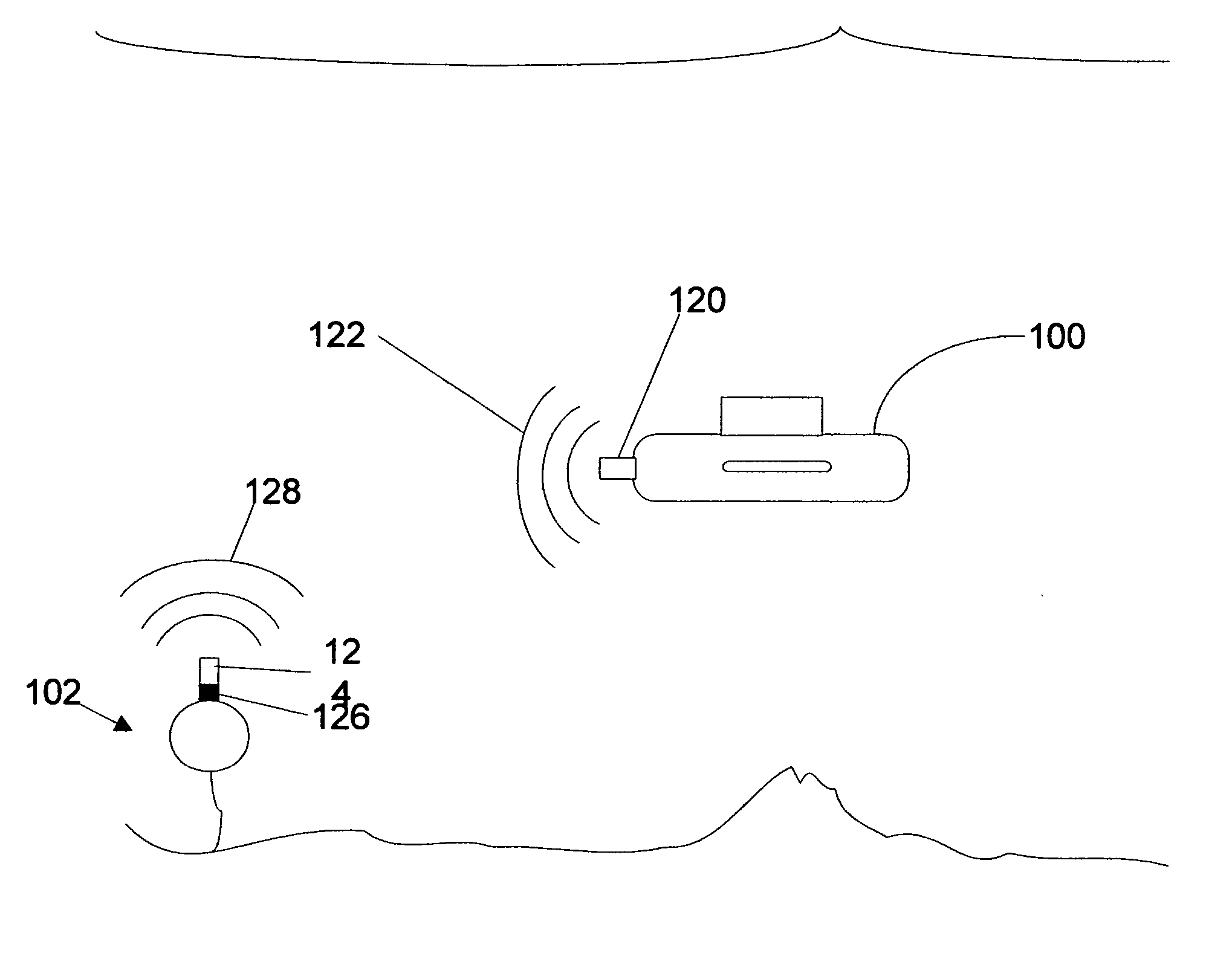
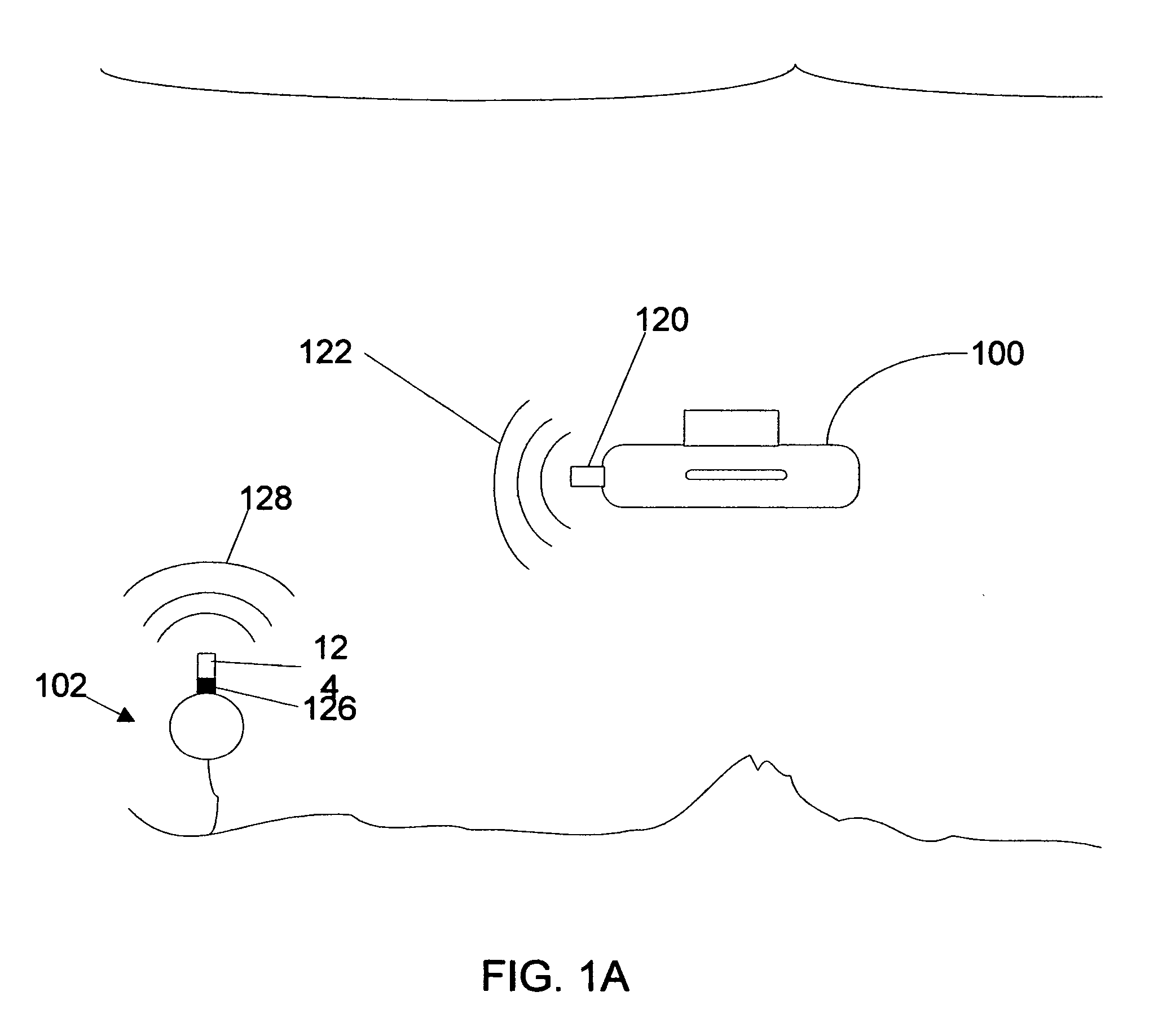
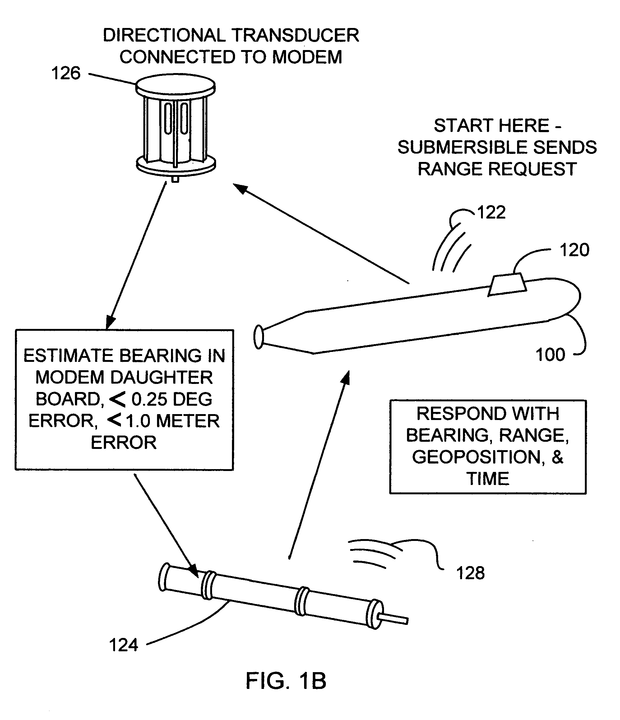
[0028] The invention includes a broadband underwater acoustic modem system which is capable of determining the geophysical position of an autonomous unit while providing a mechanism for transferring data through broadband acoustic signals between base and mobile systems. FIG. 1 illustrates the elements of an embodiment of the invention in an underwater environment. A submersible 100 includes an underwater acoustic modem system with transducer 120 that is used to transmit a request signal 122. A fixed base system 102 receives signal 122 at a multi-transceiver array 126 from which the bearing of signal 122 is determined. The depth, geophysical position of the fixed base system 102 is known and, together with a bearing calculation of the original request signal, is transmitted within a broadband reply signal through a transducer 124 to submersible 100. A timing mechanism (not shown) is employed to measure the time of travel of one or more signals between the systems. This can be accomp...


PUM


Abstract

A method and apparatus for determining the geophysical position of an autonomous underwater system utilizing underwater acoustic modems that exchange broadband underwater acoustic signals. The method of the invention includes the steps of initiating an exchange of broadband acoustic signals between the autonomous system of unknown geophysical position and a base system of known geophysical position wherein the depths of both systems is known. A bearing calculation is made on one of the signals transmitted between the systems, preferably through the use of an array of hydrophones placed closely together at predetermined locations on either the autonomous or base system. Also, the range between the two systems is determined by measuring the time of travel of at least one signal. By the acoustic transmission and sharing of information, as needed, about the known depths of the systems, the known geophysical position of the base system, and the range between the systems, sufficient data is gathered at one or both systems and used to determine the geophysical position of the autonomous system.

Description

CROSS-REFERENCE TO RELATED APPLICATION [0001] This application claims the benefit of priority from pending U.S. Provisional Patent Application No. 60 / 675,250 entitled UNDERWATER GEOPOSITIONING METHODS AND APPARATUS which was filed on Apr. 27, 2005 the entire contents of which are incorporated herein by reference.GOVERNMENT LICENSE RIGHTS [0002] The U.S. Government has a paid-up license in this invention and the right in limited circumstances to require the patent owner to license others on reasonable terms as provided for by the terms of SBIR Contract No. N00014-02-M-0135 awarded by the Office Of Naval Research.FIELD OF THE INVENTION [0003] This invention in general relates to underwater geopositioning methods and apparatus and in particular to methods and apparatus by which the geophysical position of an autonomous underwater system can be determined through the use of underwater acoustic modems exchanging broadband acoustic communication signals. BACKGROUND AND INVENTION [0004] Un...

Claims


Application Information

Patent Timeline
Patent Type & Authority Applications(United States)
IPC IPC(8): G01S3/80
CPCB63J99/00B63J2099/008G01S3/808G01S15/74G01S5/0054G01S5/18G01S3/8083B63B79/10
Inventor GREEN, MAURICE D.SCUSSEL, KENNETH F.
Owner TELEDYNE INSTR INC
Why Eureka
Try Eureka