Location-based interactive web-based multi-user community site

a multi-user, interactive technology, applied in the direction of web data retrieval, instruments, reradiation, etc., can solve the problem that none of them provides bidirectional information flow

Inactive Publication Date: 2007-04-12
IM WANSOO
View PDF6 Cites 35 Cited by
  • Summary
  • Abstract
  • Description
  • Claims
  • Application Information

AI Technical Summary

Problems solved by technology

None of them provides bidirectional information flow.

Method used


Image

  • Location-based interactive web-based multi-user community site
  • Location-based interactive web-based multi-user community site
  • Location-based interactive web-based multi-user community site

Examples


example 1

HIV Resource Inventory

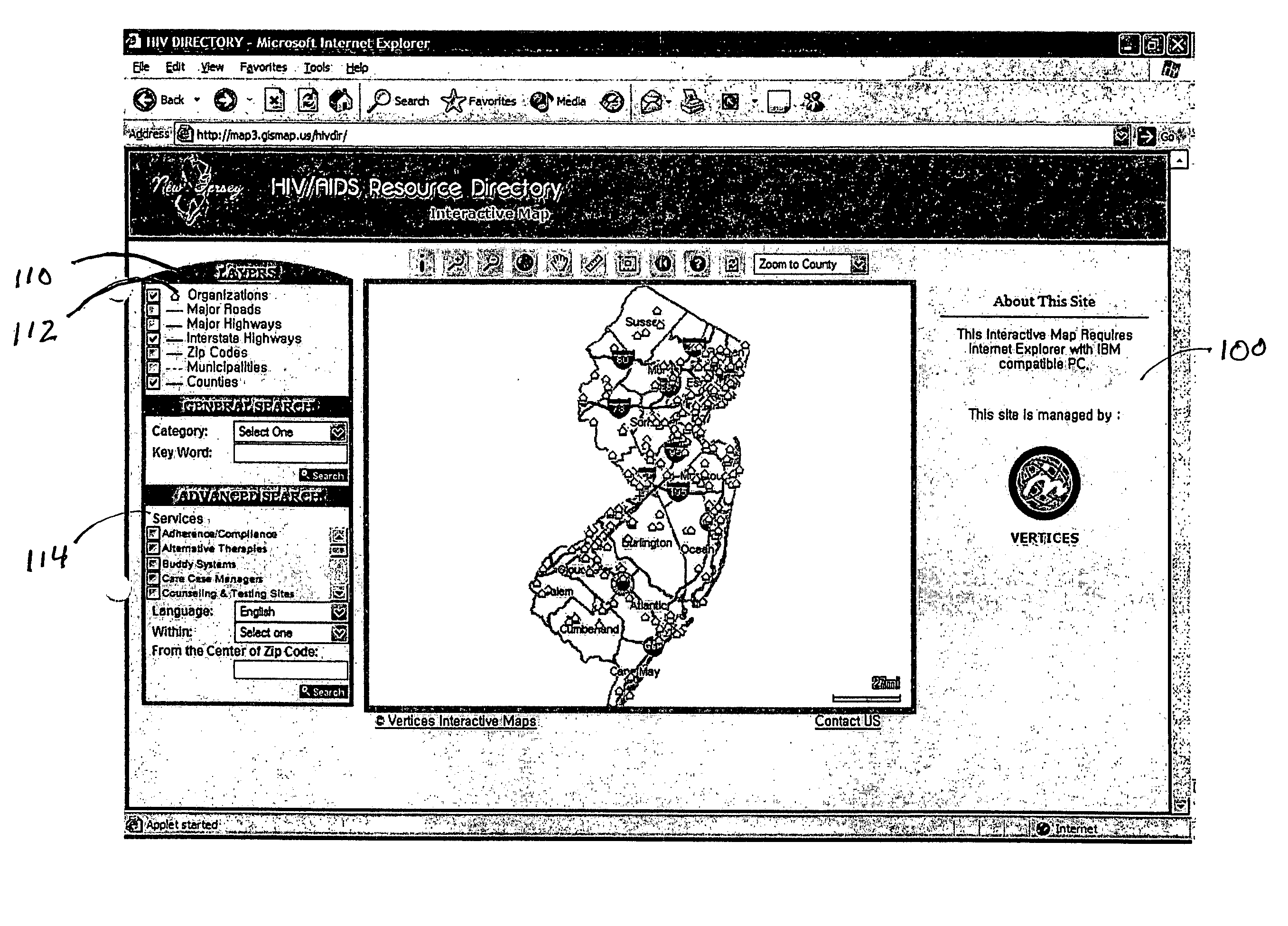
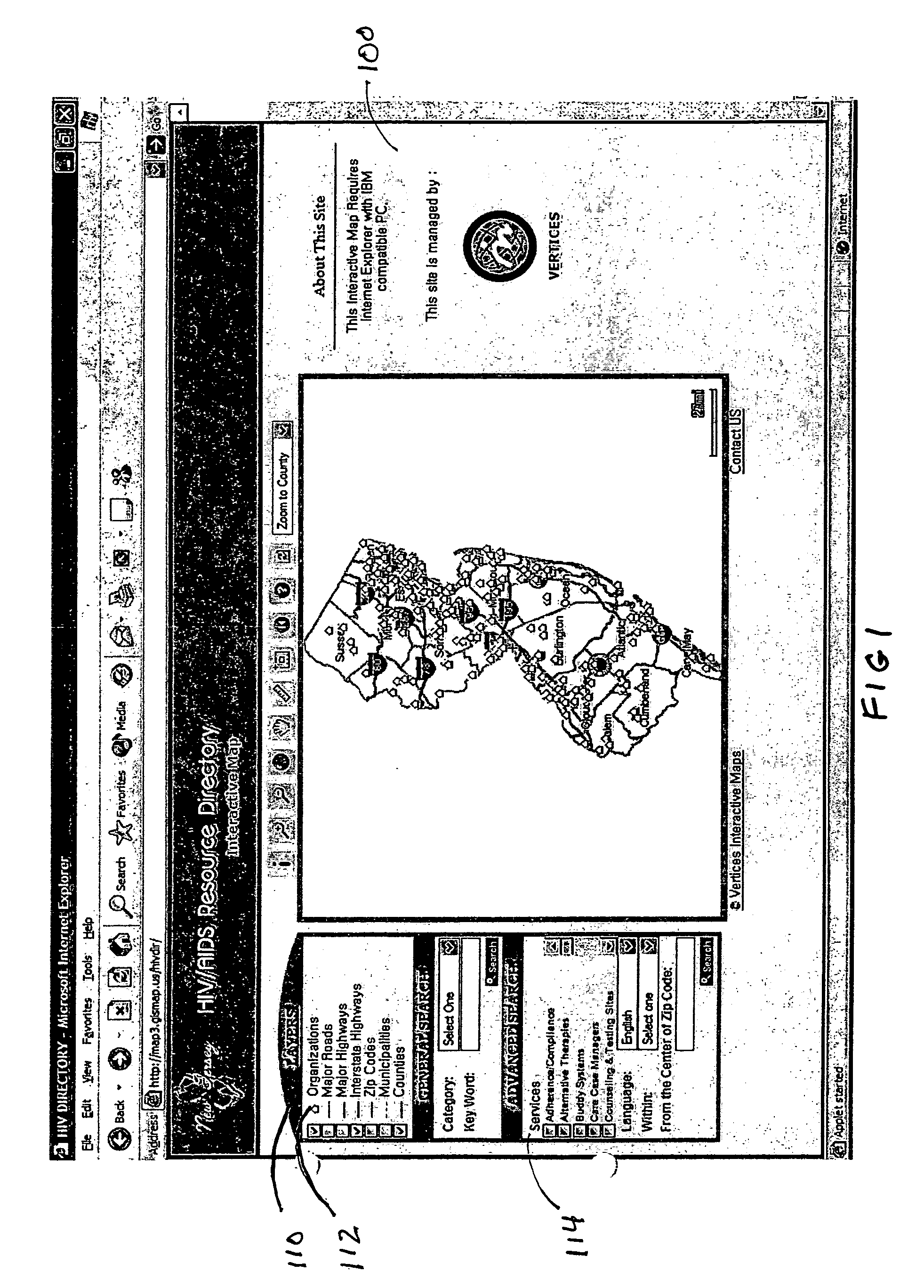
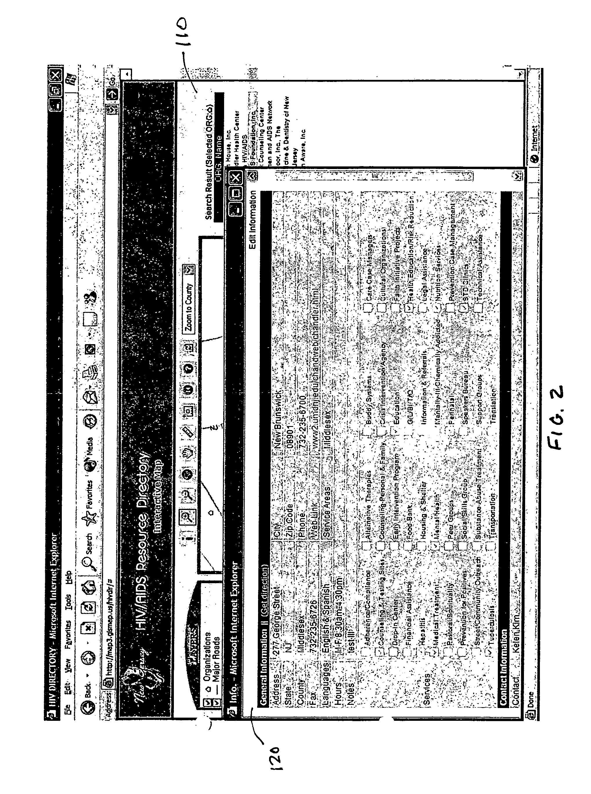
[0020] As illustrated in FIGS. 1 and 2, this interactive mapping site 100 enables the storage, query and view of HIV service providers' information in a web-based mapping format. Each service provider preferably has their own password-protected account, and the ability to update their information via the Internet in real time. The information, including point location, can be updated via the Internet. The GUI displays typical GIS layers 110 such as roads, zip codes, and municipalities. It also displays an organization layer 112 which indicate the geographic location for which descriptive data are entered into the system database. The system has an advanced query interface 114 which permits searching by typical GIS data types such as zip code and distance as well data attributes of the data fields associated with the organizations such as whether the organization offers alternative therapies, adherence / compliance, buddy systems, etc.

[0021]FIG. 2 illustrates th...

example 2

My Favorite Places in West Windsor

[0022] With reference to FIG. 3, this website 140 is developed to assist school children in collecting and sharing community data such as locations of (and information about) parks and recreation facilities, schools, libraries, foods / sweets shops, etc. The location information can be updated with GPS-collected point data (latitude and longitude), or simply by clicking on a map to get latitude and longitude. The location and attribute (descriptive) information is entered into a database on an Internet server via input interface and other visitors can query and view the information through the query interface 142. The users can also update or edit the attribute data for the location data.

[0023] This particular site is developed using the Google Maps API Beta version. The same application can be developed with the MapQuest API or the Yahoo! Maps API. The map API can also be developed using proprietary map services such as are available through ESRI o...

example 3

Archive of Architecture

[0026] With reference to FIGS. 8 and 9, this website 160 allows community members (with free or fee-based user accounts) to add photos of existing buildings with specific architectural characteristics on an interactive map 162. The photos and their descriptive information can be directly input into the database via the interactive map. Location information is provided by the users by clicking on the interactive map.

[0027] The photos of the buildings and the related information (blueprints, sketches, or drawings) can be searched based on a spatial query and can be viewed on the interactive map.

[0028]FIG. 8 illustrates a GIS displaying an interactive map of Manhattan in New York City. FIG. 9. illustrates a GUI 164 for displaying data associated with particular location on the map.


PUM


Abstract

The present invention comprises a system for creating a multi-user internet community site with location-based information (Geographic Information System). Location-based information is maintained by the community of users in a manner similar to blog content (text, photos) and is managed in a manner similar to presently existing multi-user sites (such as Flickr.com, MySpace.com, TheFacebook.com). Community groups, organizations, or individuals can create a free or fee-based account and launch their own multi-user website with a location-based component. All information has a location-based component. Location information can be added and updated through a variety of geospatial reference methods (e.g., latitude and longitude, or UTM, or State Plane). Either by using GPS-collected data, or through direct user interaction with the map (e.g., a user can click on the interactive map and store information with spatial references). Preferably, all information can be added and updated via a browser or other device over the Internet. Digital photos, videos, sounds, or other multimedia content created with a mobile device with GPS capabilities can be sent directly to the website along with their with spatial reference, for sharing with a community or other individuals.

Description

BACKGROUND OF THE INVENTION [0001] The primary function of the site is to organize and archive location-based community or other service provider information in an interactive way. [0002] At present there are many websites which provide information in an Internet mapping format. All of these sites are pre-packaged and pre-customized Internet applications. None of them provides bidirectional information flow. SUMMARY OF THE INVENTION [0003] The present invention comprises a system for creating a multi-user internet community site with location-based information (Geographic Information System). Location-based information is maintained by the community of users in a manner similar to blog content (text, photos) and is managed in a manner similar to presently existing multi-user sites (such as Flickr.com, MySpace.com, TheFacebook.com). Community groups, organizations, or individuals can create a free or fee-based account and launch their own multi-user website with a location-based comp...

Claims


Application Information

Patent Timeline
Patent Type & Authority Applications(United States)
IPC IPC(8): G06F19/00
CPCG06F17/3087G06F17/3089G06F16/958G06F16/9537
Inventor IM, WANSOO
Owner IM WANSOO
Why Eureka
Try Eureka