A method of reporting errors in map data used by navigation devices

a technology of map data and navigation devices, applied in the direction of distance measurement, navigation instruments, instruments, etc., can solve the problems of a year or more out of date data for some geographic areas, and considerable effort must be expended in working out what the error really means, so as to reduce license fees, facilitate accurate positioning, and quickly validate

Inactive Publication Date: 2008-04-03
TOMTOM INT BV
View PDF4 Cites 151 Cited by
  • Summary
  • Abstract
  • Description
  • Claims
  • Application Information

AI Technical Summary

Benefits of technology

[0013]The map error report itself can be stored as a text entry with a location reference or geo-reference; this geo-reference is obtained from GPS data generated by the device. A typical map error report could be a report that the name of a road is incorrect. The map error report can be sent back to the server as part of synchronisation. Because the map error report is geo-referenced, it is much easier to accurately locate and hence rapidly validate. The remote server can send the map error reports to the original provider of the map data, or some commercial arrangement arrived at. For example, the entity controlling the server could reduce the license fees it pays to a provider of the map data in exchange for supplying the map error reports.

Problems solved by technology

Despite the huge resources that go into updating and verifying these maps, the data for some geographic areas may be a year or more out of date.
These error reports are generally just in a free text format, so that considerable effort has to be expended in working out what the error really means and what exact location they relate to.

Method used


Image

  • A method of reporting errors in map data used by navigation devices
  • A method of reporting errors in map data used by navigation devices
  • A method of reporting errors in map data used by navigation devices

Examples


Embodiment Construction

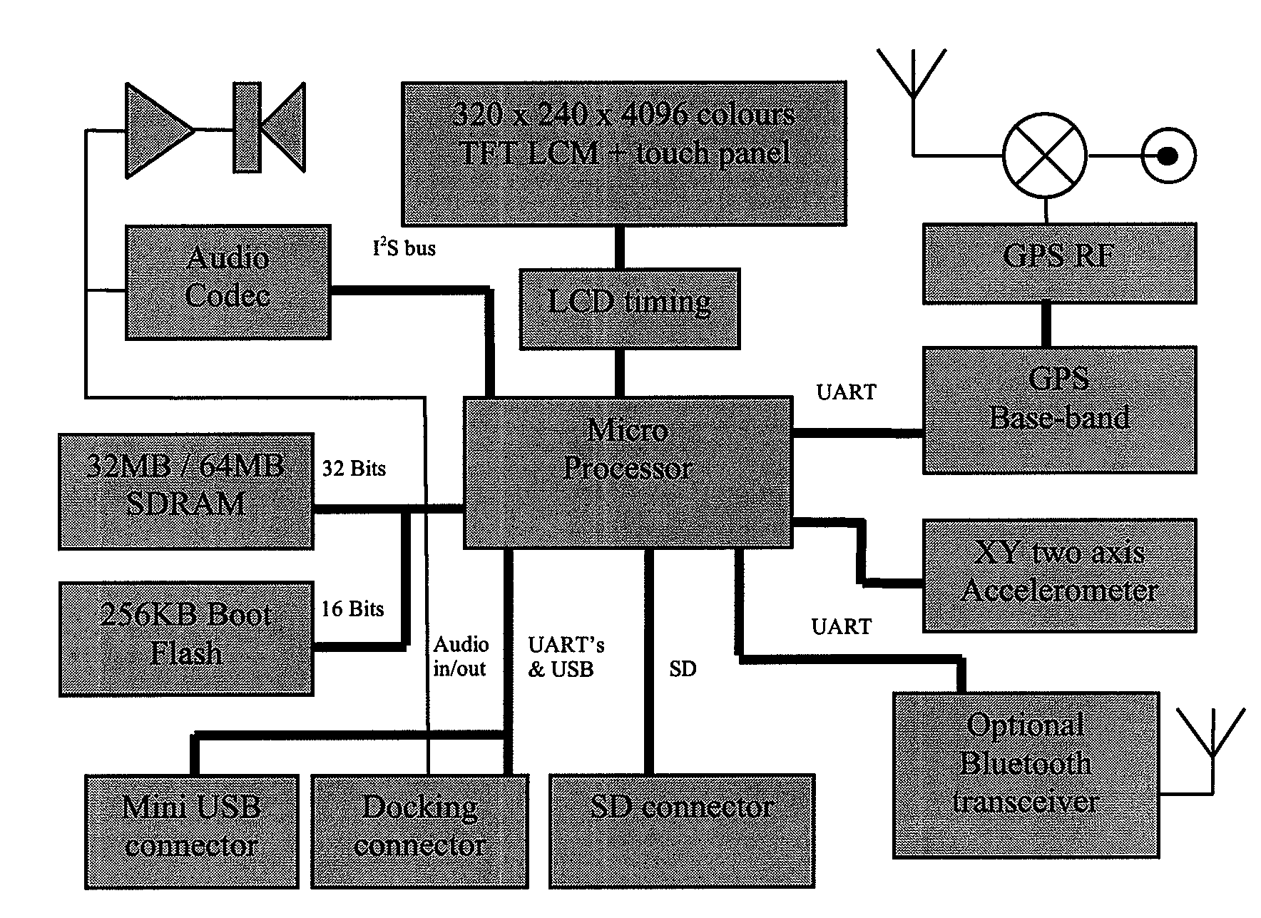
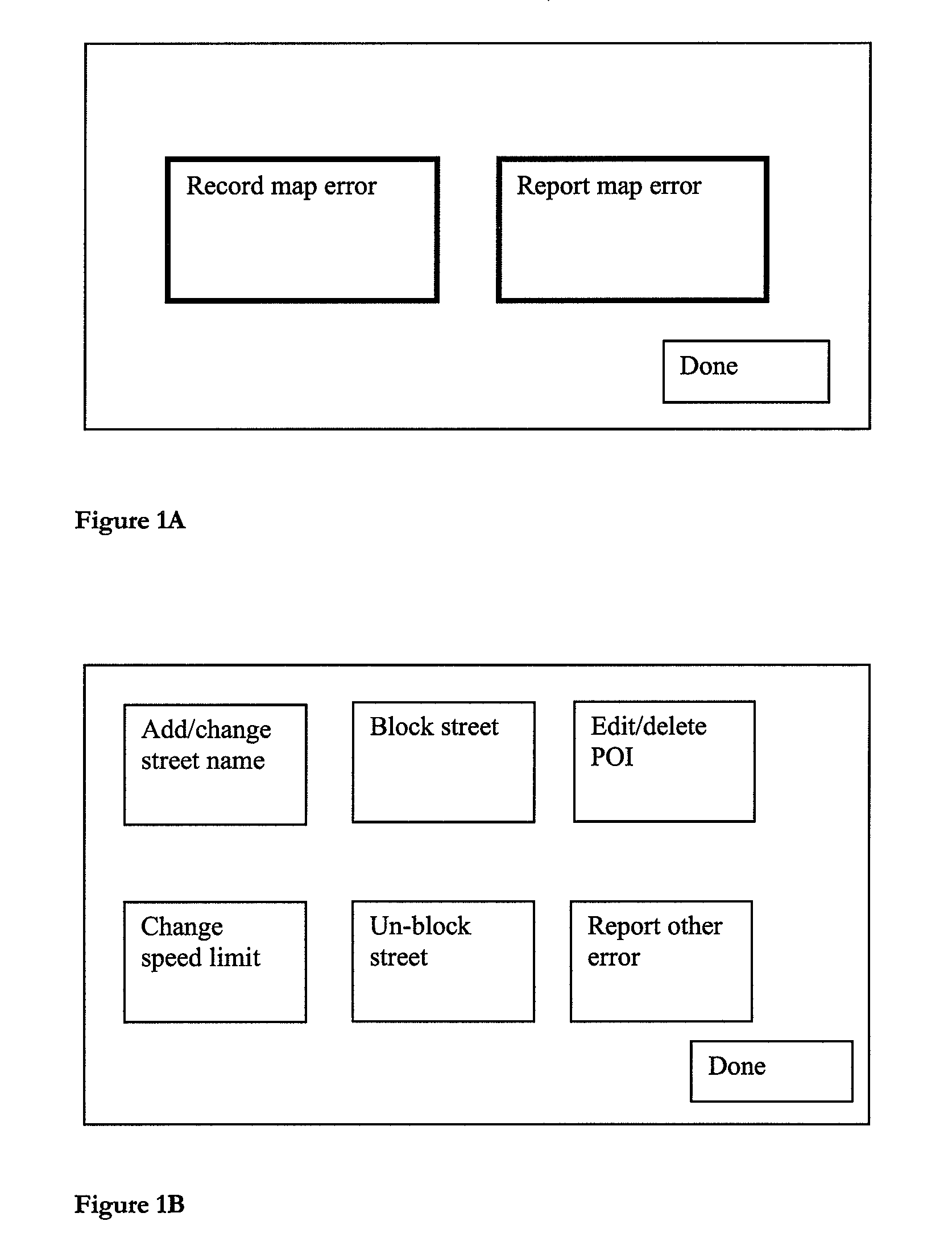
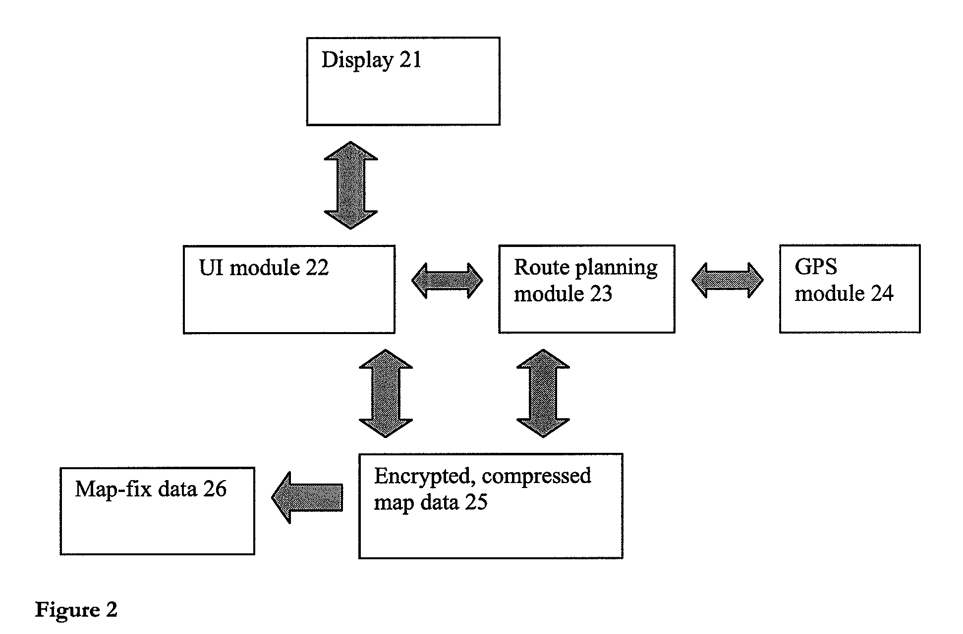
[0032]With an implementation of the present invention, it is no longer necessary for an end-user to be restricted to reporting errors to the map vendor over a web link, then waiting for that map vendor to verify the error, update its maps and supply the update—a cycle that can take months and sometimes years to complete. Instead, the navigation device itself allows a user to input a required map error report; the device can then automatically geo-reference the map error report if necessary. Geo-referencing may not be needed for all map error reports. For example, a name change to a road does not. But a width restriction preventing lorries entering a road should be.

[0033]The device then stores this map error report and sends it (directly or indirectly) to a server that aggregates the map error reports and, typically, sends those reports to a map vendor (or in some cases the device manufacturer). The map error reports are used to construct appropriate corrections. Hence, later release...


PUM


Abstract

An end-user can input a map error report to a map error, directly on the device. The device stores the map error report and can send the report to a remote server for processing. Hence, it is no longer necessary for an end-user to simply report errors to the map vendor over a web link, then wait for that map vendor to verify the error, update its maps and finally supply the end-user with updates—a cycle that can take months and sometimes years to complete.

Description

FIELD OF THE INVENTION[0001]This invention relates to a method of reporting errors in map data used by navigation devices. Navigation devices include GPS based electronic personal navigation devices.DESCRIPTION OF THE PRIOR ART[0002]Map data for electronic navigation devices, such as GPS based personal navigation devices like the GO™ from TomTom International BV, comes from specialist map vendors such as Tele Atlas NV. This map data is specially designed to be used by route guidance algorithms, typically using location data from the GPS system. For example, roads can be described as lines—i.e. vectors (e.g. start point, end point, direction for a road, with an entire road being made up of many hundreds of such sections, each uniquely defined by start point / end point direction parameters). A map is then a set of such road vectors, data associated with each vector (speed limit; travel direction etc.) plus points of interest (POIs), plus road names, plus other geographic features like ...

Claims


Application Information

Patent Timeline
Patent Type & Authority Applications(United States)
IPC IPC(8): G05D1/00G01C22/00
CPCG01C21/32G01C21/3811G01C21/3856G01C21/3815
Inventor BARRETT
Owner TOMTOM INT BV
Why Eureka
Try Eureka