Method for Processing Images Using Automatic Georeferencing of Images Derived from a Pair of Images Captured in the Same Focal Plane

Active Publication Date: 2008-04-17
CENT NAT DETUD SPATIALES C N E S
View PDF13 Cites 50 Cited by
  • Summary
  • Abstract
  • Description
  • Claims
  • Application Information

AI Technical Summary

Benefits of technology

[0024] It is also desirable to offer a technique for the georeferencing of remote image acquisitions that, firstly, allows use of the data available to any user and, secondly, achieves a saving in terms of cost and tim

Problems solved by technology

This model is always of limited precision, through lack of sampling of the focal plane, and because of sampling and filtering of the attitude data.
The raw images obtained by a sensor cannot be georeferenced directly in a precise manner, since they include global or local deformations that are not modelled perfectly.
When no map is available, or its precision is inadequate, then one has to resort to finding control points by conventional geodesic methods or by use of the global positioning system (GPS).
This is a leng

Method used


Image

  • Method for Processing Images Using Automatic Georeferencing of Images Derived from a Pair of Images Captured in the Same Focal Plane
  • Method for Processing Images Using Automatic Georeferencing of Images Derived from a Pair of Images Captured in the Same Focal Plane
  • Method for Processing Images Using Automatic Georeferencing of Images Derived from a Pair of Images Captured in the Same Focal Plane

Examples


Example

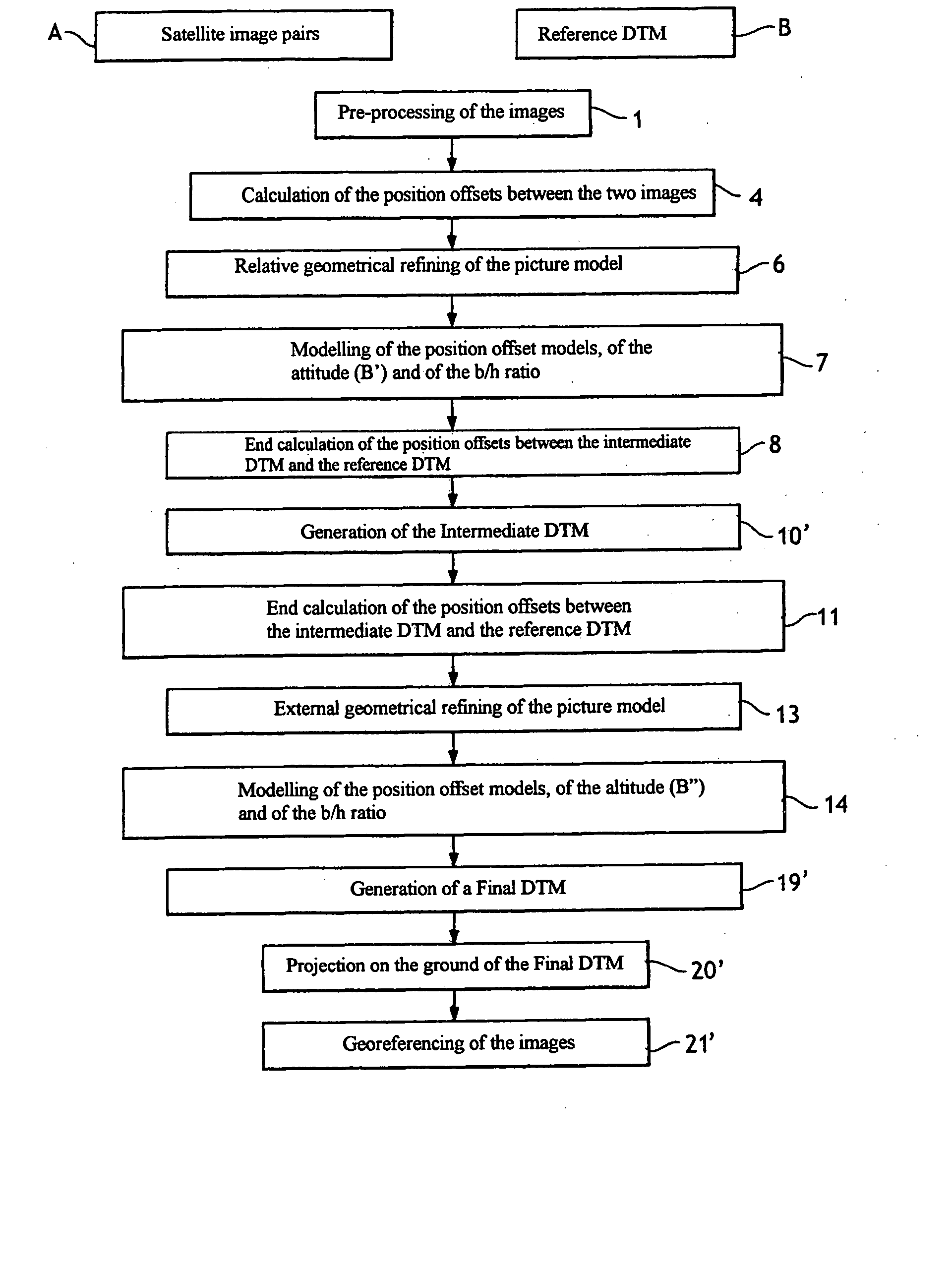
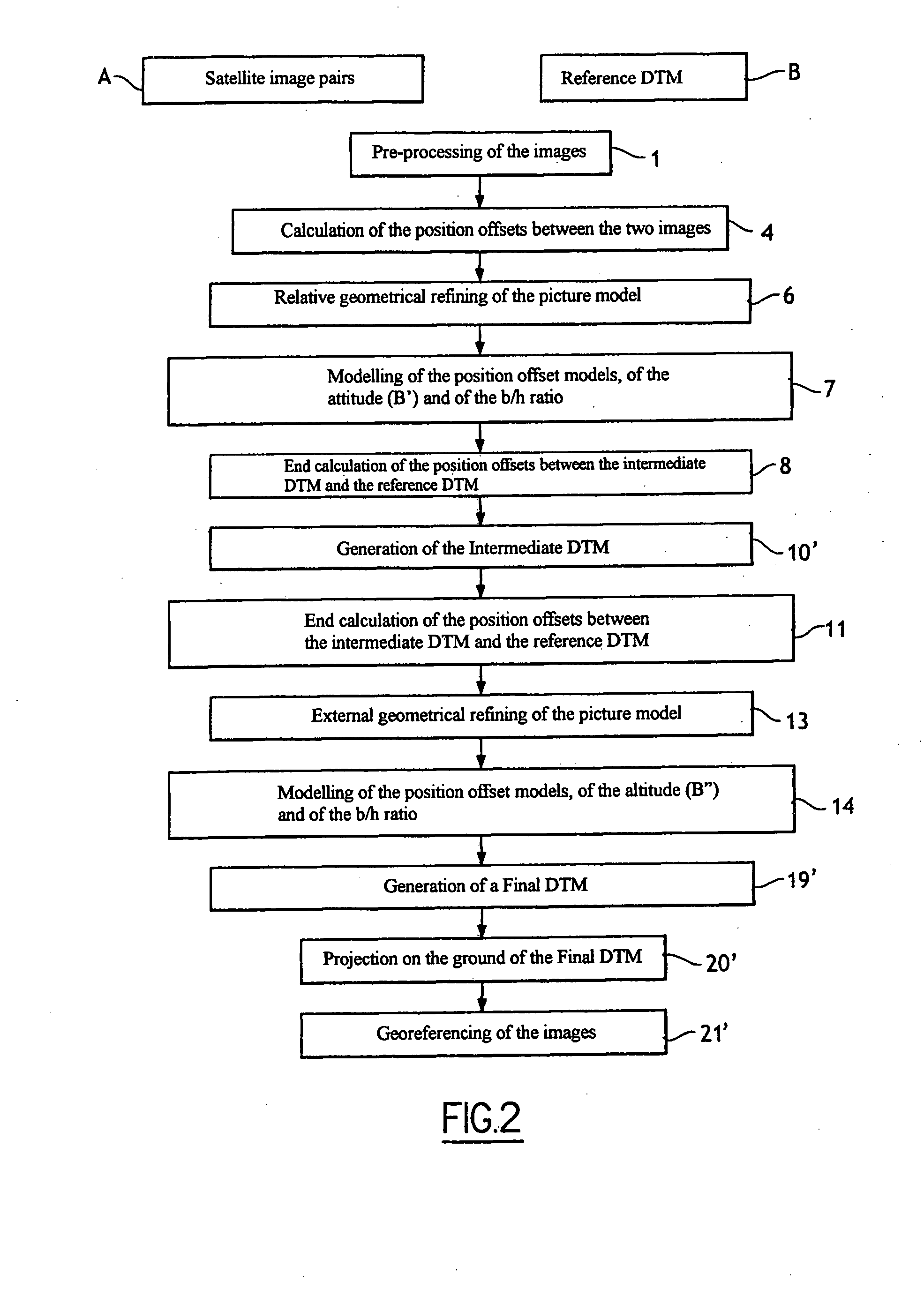
[0039] As shown in FIG. 2, the method requires the acquisition of an image pair A. Two CCD elements (or two sets of adjacent CCD elements) or two TDI matrices (or two sets of adjacent TDI matrices) located in the same focal plane are used to acquire the two satellite images of the observed scene at a certain distance from the sensors. The pair acquisition system will be described in detail later.

[0040] According to the nature and the characteristics of the images acquired by the sensors, a first pre-processing stage (stage 1) is provided before any processing of the images. This will be described in detail later, with reference to FIG. 3.

[0041] More precisely, the method is based on acquisition of the image pair A in a small stereoscopic base configuration, and on the availability of a digital terrain model, referenced B, of the observed scene. The method works even with very small stereoscopic coefficients b / h, but the altimetric precision obtained is inversely proportional to th...


PUM


Abstract

An image processing system in which the georeferencing of at least one digital image is achieved by means of at least one picture model of the said digital image and of a digital reference relief form. The digital image is obtained from a pair of digital images acquired in the same focal plane. An intermediate digital relief form is produced from said pair of digital images. The intermediate digital relief form and said digital reference relief form are processed to refine the said picture model of the said digital image to be georeferenced. A final digital relief form is generated and said final digital relief form and said digital image are projected in a geographical or cartographic system, for the purpose of their georeferencing. The pair of digital images in the same focal plane are acquired in a small stereoscopic base configuration by sensors located in the same focal plane.

Description

FIELD OF THE INVENTION [0001] The field of the invention is that of remote image acquisition, and in particular the acquisition of images transmitted terrestrially or by satellite. More precisely, the invention concerns a method for automatically georeferencing the remote acquisition of images, meaning that the invention concerns a method that is used to automatically associate, with the elements for the remote acquisition of images, a position that is determined by geographical or cartographic coordinates. PRESENTATION OF PRIOR ART [0002] A remotely-acquired image supplies a three-dimensional, spatially-sampled representation of a region on the ground called a scene. This is a representation in which each digital remotely-acquired value is representative of a small area on the ground, centred on each of the points of the sampling grid. [0003] The majority of remotely-acquired imagery applications necessitate a method called georeferencing, which establishes a geometrical relationsh...

Claims


Application Information

Patent Timeline
IPC IPC(8): G06K9/00G06K9/62G06T17/05
CPCG06T17/05G01C11/06
Inventor VADON, HELENELATRY, CHRISTOPHE
Owner CENT NAT DETUD SPATIALES C N E S
Why Eureka
Try Eureka