System, computer program and method for 3D object measurement, modeling and mapping from single imagery

a computer program and single imagery technology, applied in the field of system, computer program and method for 3d object measurement, modeling and mapping from single imagery, can solve the problem that the dimensions of moving objects are not readily measured using stereo pairs

Inactive Publication Date: 2008-04-17
MICROSOFT CORP
View PDF3 Cites 83 Cited by
  • Summary
  • Abstract
  • Description
  • Claims
  • Application Information

AI Technical Summary

Benefits of technology

[0013]The computer program of the present invention consists of a computer application that includes (1) a measurement utility that enables measurements to be made from a 2D image that supports the IGM, the measurement utility including a projection measurement utility and a shadow measurement utility. The projection measurement utility and the shadow measurement utility co-operate so as to enable point-to-point measurements by operation of the projec

Problems solved by technology

Thus the dimensions of the moving objects a

Method used


Image

  • System, computer program and method for 3D object measurement, modeling and mapping from single imagery
  • System, computer program and method for 3D object measurement, modeling and mapping from single imagery
  • System, computer program and method for 3D object measurement, modeling and mapping from single imagery

Examples


example 1

Measuring when the Full Projection is Visible

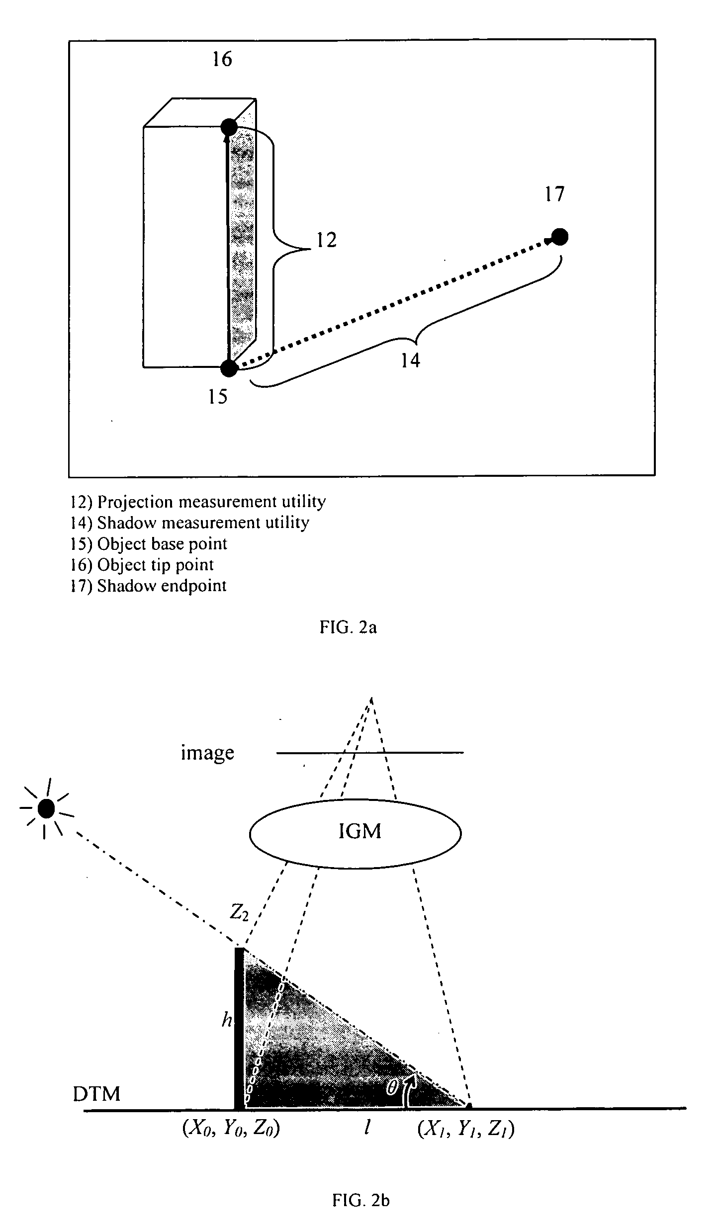
[0094]An experiment was conducted to demonstrate advantages of the present invention in connection with projection-based measurement. A projection ruler can be drawn, visualizing adjusted height information iteratively until the ruler line reaches the true tip of the object. In FIG. 4a, line 1001 represents the outline of the building. As the operator begins by indicating the base of the building (thick black circle 1002) and then raises the height (thick black line 1003) of the floating cursor. As the cursor is raised iteratively, its position in the image is computed by the IGM on in the real time and the cursor is continuously drawn in the graphic user interface. Once the cursor touches the roof edge in the image (thick black circle 1004), this interactive procedure stops. In actual interface line 1003 will be appeared as green as a representative embodiment of the present invention. The height of the roof, as shown in FIG. 4b is 48.6 ...

example 2

Measuring when the Full Shadow is Visible

[0102]An experiment was conducted to demonstrate advantages of the present invention for the purpose of shadow-based measurement. A shadow ruler (in actual interface the line will be appeared as blue as a representative embodiment of the present invention) is drawn on the image in the graphic user interface illustrate herein. Height information is iteratively adjusted until the ruler line fits the whole shadow in the image. As shown in FIG. 8a, the operator begins by locating the end point of the object's shadow (circle 1005) in the image and then raises the height of the floating cursor. As the cursor is raised, the position of the base point is updated as described in FIG. 7b, and their locations in the image are computed by the IGM. A line (dotted line 1006) connecting the base point and shadow endpoint and a second line (1007) connecting the base point and the raised cursor are drawn in the graphic user interface. Once the cursor reaches ...

example 3

Measuring when the Projection and Shadow are Partially Visible

[0103]Several cases are performed to demonstrate advantages of the present invention of shadow-based measurement for immeasurable projections and shadows. In following cases, the base points of the objects can not be located reliably or do not exist, but the shadow ruler can locate the base point accurately. In FIG. 9 the shadow (1009) is measured by a dotted line, and the projection (1010) is measured by a bold line. The intersection of the two lines is the base point to be located.

[0104]FIG. 9a shows the measurement of an airplane in the air. The airplane is in the air and has no physical base point on the ground. The measured height is 57.1 m. In FIG. 9b, an overpass is measured, the dotted line (1011) is the measured shadow length and the thick line (1012) is the measured projected height (13.8 m). In FIG. 9c, a tree is measured, the dotted line (1013) is the measured shadow length and the thick line (1014) is the mea...


PUM


Abstract

A method for deriving three-dimensional measurement information and/or creating three-dimensional models and maps, from single images of at least one three-dimensional object is provided. The method includes the steps of: (a) obtaining at least one two-dimensional single image of the object, the image consisting of image data and being associated with an image geometry model (IGM); (b) deriving three-dimensional coordinate information associated with the image, based on the IGM, and associating the three-dimensional coordinate information with the image data; (c) analyzing the image data so as to: (i) measure the projection of the object using the IGM to derive measurement data including the height and/or point-to-point distances pertaining to the object; and/or (ii) measure the shadow of the object to derive measurement data including the height and/or point-to-point distance pertaining to the object; and (d) obtaining three-dimensional measurements based on the projection and/or shadow measurements of the object. In another aspect of the method, the method includes the further step of creating three-dimensional models or maps based on the projection and/or shadow measurements. A series of algorithms are also provided for processing the method of the invention. A computer system and related computer program for deriving three-dimensional measurement information and/or creating three-dimensional models and maps, from single images of at least one three-dimensional object is provided based on the disclosed method is also provided.

Description

FIELD OF THE INVENTION [0001]The present invention relates to mapping, surveying, photogrammetry, remote sensing, visualization and simulation, gaming, planning, geomatics, civil engineering, geography, and more particularly relates to the collection of measurement and dimension information of or between objects from single images, and the three-dimensional (3D) models and maps and the subsequent use of such information in analysis, modeling, mapping and visualization.BACKGROUND OF THE INVENTION [0002]A conventional method of measuring 3D objects is called stereo-vision that obtains paired stereo images taken of the same objects. When the imagery geometry model (IGM) of each image is given, the 3D coordinate information of the objects can be determined. A photogrammetric method surveys the objects by selecting conjugate points, and thereby measure any dimension using the IGMs based on these points. The 3D models and maps are then generated by using the stereo-vision approaches.[0003...

Claims


Application Information

Patent Timeline
IPC IPC(8): G06K9/00G06K9/36G01C11/00G01C11/04G06T7/00G06T17/05
CPCG06T17/05G06T7/0051G06T7/50G01C11/04G01C11/00
Inventor TAO, C. VINCENTHU, YONGLENSON, PETERCROITORU, ARIEJIANG, WANSHOU
Owner MICROSOFT CORP
Why Eureka
Try Eureka