System and method for full azimuth angle domain imaging in reduced dimensional coordinate systems

a full azimuth angle and coordinate system technology, applied in the field of image data representation and processing, can solve the problems of increasing the amount of data recorded for imaging subsurface regions, providing computational and/or power intensive services, and insufficient accuracy of image geophysical structures

Active Publication Date: 2008-05-08
PARADIGM GEOPHYSICAL LTD +1
View PDF7 Cites 66 Cited by
  • Summary
  • Abstract
  • Description
  • Claims
  • Application Information

AI Technical Summary

Problems solved by technology

Such methods may increase the amount of data recorded for imaging subsurface regions.
Such systems may provide computationally and / or power intensive services.
CIGs generated using traces that share a single azimuth (e.g., offset, opening angle, etc.) may image geophysical structures with insufficient accuracy.
Although three-dimensional CIGs may increase imaging accuracy, they may also increase the computational complexity of imaging, visualization, and / or interpretation systems using such gathers.
Operation of three-dimensional CIGs may also require extensive memory and storage capacity.
These other methods may similarly generate large amounts of data and have large computational needs.
Other types of imaging, such as medical imaging, may also use a relatively large number of transmitters and detectors and therefore may also use a relatively large amount of data, which may require large storage and intensive computational efforts.

Method used


Image

  • System and method for full azimuth angle domain imaging in reduced dimensional coordinate systems
  • System and method for full azimuth angle domain imaging in reduced dimensional coordinate systems
  • System and method for full azimuth angle domain imaging in reduced dimensional coordinate systems

Examples


Embodiment Construction

Introduction

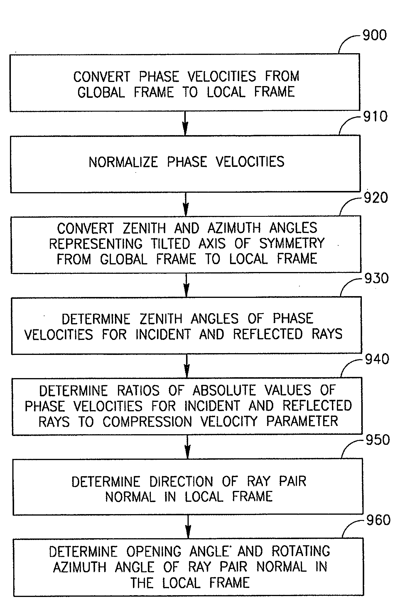
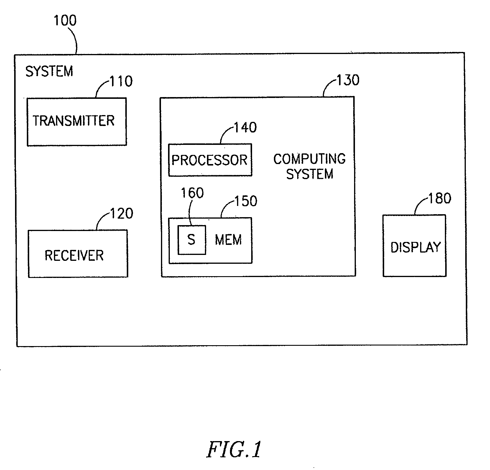
[0035]In the following description, various aspects of the present invention will be described. For purposes of explanation, specific configurations and details are set forth in order to provide a thorough understanding of the present invention. However, it will also be apparent to one skilled in the art that the present invention may be practiced without the specific details presented herein. Furthermore, well known features may be omitted or simplified in order not to obscure the present invention. Unless specifically stated otherwise, as apparent from the following discussions, it is appreciated that throughout the specification discussions, utilizing terms such as “processing,”“computing,”“calculating,”“determining,” or the like, refer to the action and / or processes of a computer or computing system, or similar electronic computing device, that manipulates and / or transforms data represented as physical, such as electronic, quantities within the computing system's reg...


PUM


Abstract

Embodiments of the invention provide a system and method for converting coordinate systems for representing image data such as for example seismic data, including accepting a first set of seismic data, mapping the first set of seismic data to a second set of seismic data, where the dimensionality of the second set of seismic data is less than the dimensionality of the first set of seismic data, and generating image data by processing the second set of seismic data.

Description

PRIOR APPLICATION DATA[0001]The present application claims benefit of prior provisional application Ser. No. 60 / 856,303, filed on Nov. 3, 2006, entitled “Uniform Spherical Spiral Imaging”, incorporated by reference herein in its entirety.FIELD OF THE INVENTION[0002]The present invention relates to the representation and processing of image data, such as three-dimensional seismic data.BACKGROUND OF THE INVENTION[0003]A transmitter located on the earth's surface or elsewhere may transmit signals, such as acoustic waves, compression waves or other energy rays or waves, that may travel through subsurface structures. The transmitted signals may become incident signals that are incident to subsurface structures. The incident signals may reflect at various transition zones or geological discontinuities throughout the subsurface structures. The reflected signals may include seismic events. Seismic events including, for example, primary (P) waves and shear (S) waves (e.g., transverse waves i...

Claims


Application Information

Patent Timeline
Patent Type & Authority Applications(United States)
IPC IPC(8): G01V1/28G06F17/00
CPCG01V1/32G01V2210/40G01V1/34
Inventor KOREN, ZVIRAVVE, IGOR
Owner PARADIGM GEOPHYSICAL LTD
Why Eureka
Try Eureka