
Multi-rotor unmanned aerial vehicle-mounted circular track SAR (synthetic aperture radar) full-aperture imaging method

A multi-rotor unmanned, circular trajectory technology, applied in the direction of radio wave reflection/re-radiation, radio wave measurement system, using re-radiation, etc., to achieve the effect of high-resolution large scene imaging

Active Publication Date: 2019-06-25
NANJING UNIV OF AERONAUTICS & ASTRONAUTICS +1
View PDF2 Cites 7 Cited by
  • Summary
  • Abstract
  • Description
  • Claims
  • Application Information

AI Technical Summary

Problems solved by technology

[0004] The technical problem to be solved by the present invention is to provide a full-aperture imaging method for circular trajectory surround-view SAR carried by a multi-rotor UAV, and to propose an accurate full-aperture imaging processing algorithm for the deficiencies of the existing circular-arc surround-view SAR imaging method, which is highly efficient. Realized high-resolution large-scene imaging

Method used


Image

  • Multi-rotor unmanned aerial vehicle-mounted circular track SAR (synthetic aperture radar) full-aperture imaging method
  • Multi-rotor unmanned aerial vehicle-mounted circular track SAR (synthetic aperture radar) full-aperture imaging method
  • Multi-rotor unmanned aerial vehicle-mounted circular track SAR (synthetic aperture radar) full-aperture imaging method

Examples


Embodiment Construction

[0038] Embodiments of the invention are described in detail below, examples of which are illustrated in the accompanying drawings. The embodiments described below by referring to the figures are exemplary only for explaining the present invention and should not be construed as limiting the present invention.

[0039] The spectrum derivation process of airborne surround view SAR is as follows:

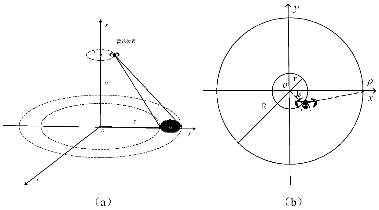
[0040] Such as figure 1 As shown in (a) and (b), assuming that the radar transmits a linear frequency modulation signal, then the echo signal can be written as:

[0041]

[0042] Among them, τ is the fast time variable in the distance direction, t is the slow time variable in the azimuth direction, K is the frequency modulation slope of the linear frequency modulation signal, and f 0 is the carrier frequency, c is the speed of light, R(t) is the distance between the radar and the target at time t, R is the radius of the circle where the target is located, θ 0 is the azimuth angle ...


PUM


Abstract

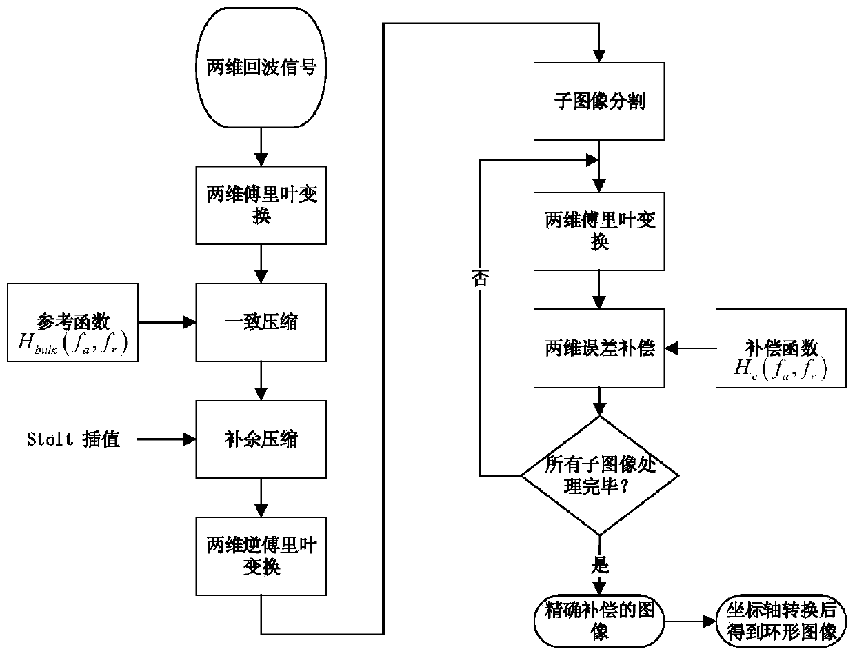
The invention discloses a multi-rotor unmanned aerial vehicle-mounted circular track SAR (synthetic aperture radar) full-aperture imaging method. The method includes the following three steps that: coarse focusing imaging process: echo signals are subjected to two-dimensional Fourier transformation, uniform compression, Stolt interpolation and two-dimensional inverse Fourier transformation, so that a coarse focusing image is obtained; image fine processing: space variant compensation is performed on phase error; and image coordinate transformation: a distance angle coordinate image is transformed into a distance azimuth coordinate image, so that a high-resolution circular image can be obtained. According to the method of the invention, a multi-rotor unmanned aerial vehicle is adopted to carry a radar to perform circular motion, the radar irradiates regions outside a circular region, and therefore, the defect of ground-based circular arc SAR can be overcome, and high-resolution large-scene imaging can be realized; and on the basis of the angular scanning invariant characteristic of the circular arc SAR, a distance angle coordinate-based echo two-dimensional spectrum analytical representation is inferred, and an improved wave number domain imaging algorithm is provided based on the analytical spectrum, and full-aperture imaging is realized.

Description

technical field [0001] The invention relates to a full-aperture imaging method for a circular track look-around SAR carried by a multi-rotor unmanned aerial vehicle, and belongs to the technical field of radar imaging. Background technique [0002] Synthetic Aperture Radar (SAR) can observe targets from multiple angles through the movement of the radar, and realize all-weather, all-weather, high-resolution imaging, which has important military and civilian values. High resolution and wide coverage have always been the two goals pursued by SAR. Circumferential trajectory surround-view SAR is a research hotspot in recent years. Through the circular motion of the radar and the emission of radar signals outside the circle, it can image the outside. Compared with the general linear trajectory SAR, this mode greatly increases the imaging coverage and has extremely high data acquisition efficiency. However, most of the circular-arc surround-view SARs currently studied are based o...

Claims


Application Information

Patent Timeline
Patent Type & Authority Applications(China)
IPC IPC(8): G01S13/90
Inventor 毛新华李丹琪莫亚军
Owner NANJING UNIV OF AERONAUTICS & ASTRONAUTICS
Learn More