
Mobile positioning system

Active Publication Date: 2008-12-11
NAT INST OF ADVANCED IND SCI & TECH
View PDF4 Cites 27 Cited by
  • Summary
  • Abstract
  • Description
  • Claims
  • Application Information

AI Technical Summary

Benefits of technology

[0028]In this case, a pixel image in the pixel image group accumulated in the image database is image data which is different in size of pixel value corresponding to the position thereof depending on ease of movement and passage in the region inside the image. Alternatively, the pixel image is image data which has a pixel value which can be converted to a value indicating ease of movement and passage at the position corresponding to each pixel image. The pixel crossing determination device is configured to calculate the crossing determination result according to the size of the pixel value on the moving path and reduce the likelihood of each position candidate group based on the degree of crossing and the size of the pixel value.
[0036]According to the mobile positioning apparatus of the present invention, the map matching based on a pixel image can remove the position candidate indicating a movement to a region inhibiting movement or difficult to move or can reduce the likelihood thereof. Thereby, it is possible to reduce an error contained in a movement vector outputted by the movement vector estimation device and increase the estimation accuracy of the position of the mobile body. In addition, the position of the mobile body is held as a position information group of a nonparametric distribution. For example, two paths run in parallel as candidates for the mobile body to pass, and the error outputted by the dead reckoning device is too large to uniquely determine which path to be taken. In this case, it is possible to trace the two candidates at the same time by generating a distribution on each of the two paths.
[0037]The mobile positioning apparatus of the present invention can provide a positioning device for a navigation system comprising a movement vector estimation device of a mobile body and a map matching device, and a navigation system in indoor and outdoor environments.

Problems solved by technology

However, for example, in an indoor environment having a complicated structure, it is difficult and impractical to create map information such as a road network, and thus a map matching techniques cannot be used effectively.
Therefore, a map matching technique based on a simple linear matching is not adequate for a human positioning purpose.
When a positioning apparatus for navigating a mobile body is implemented, a dead reckoning device for cumulatively estimating the movement vector of the mobile body has a problem in that errors are cumulatively accumulated with the passage of time.
Such correction means has a problem in that a need for working over the external environment increases a deployment cost for putting the use environment in place.

Method used


Image

  • Mobile positioning system
  • Mobile positioning system
  • Mobile positioning system

Examples


Embodiment Construction

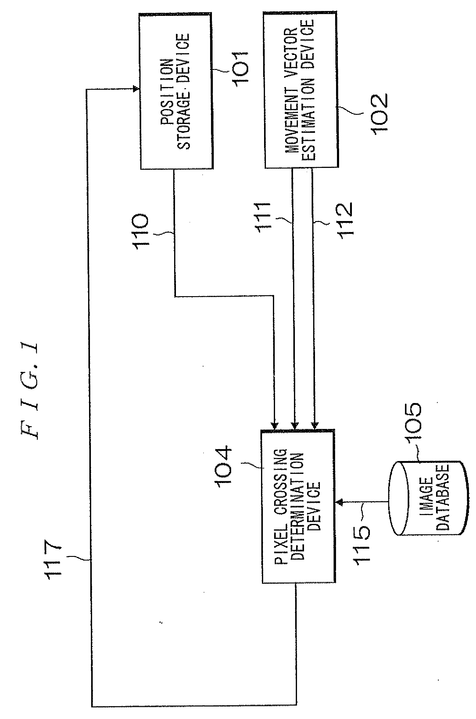
[0052]FIG. 1 is a block diagram illustrating a basic configuration of a mobile positioning apparatus in accordance with the present invention. The block diagram illustrates a flow of processing and a flow of data in the positioning apparatus. With reference to FIG. 1, reference numeral 101 denotes a position storage device; reference numeral 102 denotes a movement vector estimation device; reference numeral 104 denotes a pixel crossing determination device; reference numeral 105 denotes an image database; reference numeral 110 denotes position information group; reference numeral 111 denotes a movement vector information; reference numeral 112 denotes likelihood information; reference numeral 115 denotes image data; and reference numeral 117 denotes pixel crossing determination result data.

[0053]The position storage device 101 holds a position information group indicating a current position of a mobile body and the likelihood information thereof as a nonparametric distribution. In o...


PUM


Abstract

There is provided a mobile positioning apparatus for performing map matching based on a pixel image. The mobile positioning apparatus comprises a position storage device which holds a position information group indicating a current position of a mobile body and likelihood information thereof as a nonparametric distribution; a movement vector estimation device which outputs a movement vector indicating a moving distance and a moving direction of the mobile body at a discrete time T and likelihood information thereof; an image database which holds a peripheral map of a range of movement of the mobile body as an image group of a resolution according to a moving resolution of the mobile body; and a pixel crossing determination device which performs map matching using the position information group and the movement vector based on the peripheral map.

Description

BACKGROUND OF THE INVENTION[0001]1. Field of the Invention[0002]The present invention relates to a mobile positioning apparatus capable of accurately positioning a current position of a mobile body, for example, in a building where a GPS (global positioning system) cannot be used.[0003]2. Description of the Related Art[0004]In a navigation field, where a GPS is mainly used, a technique for covering a positioning error using map matching in a case where the GPS cannot be used has been proposed mainly as an application of a car navigation system.[0005]Most of the map matching techniques use moving path network information which treats a crossing point as a node and a moving path as a straight line, and which is used as map information to perform map matching to cover a positioning error as disclosed in Patent Documents 1 to 4 and Non-Patent Documents 1, 2, 3, and 5 described later.[0006]Therefore, the conventional map matching techniques work correctly in an orderly environment such a...

Claims


Application Information

Patent Timeline
IPC IPC(8): G01C21/16G01C21/00
CPCG01C21/165G01C21/1656
Inventor KOUROGI, MASAKATSUKURATA, TAKESHIOKUMA, TAKASHI
Owner NAT INST OF ADVANCED IND SCI & TECH
Features
  • Generate Ideas
  • Intellectual Property
  • Life Sciences
  • Materials
  • Tech Scout
  • Unparalleled Data Quality
  • Higher Quality Content
  • 60% Fewer Hallucinations
Learn More