
Method, Apparatus, and Computer Program Product for Intelligently Selecting Between the Utilization of Geo-Fencing and Map Matching in a Telematics System

Inactive Publication Date: 2009-02-26
IBM CORP
View PDF14 Cites 101 Cited by
  • Summary
  • Abstract
  • Description
  • Claims
  • Application Information

AI Technical Summary

Benefits of technology

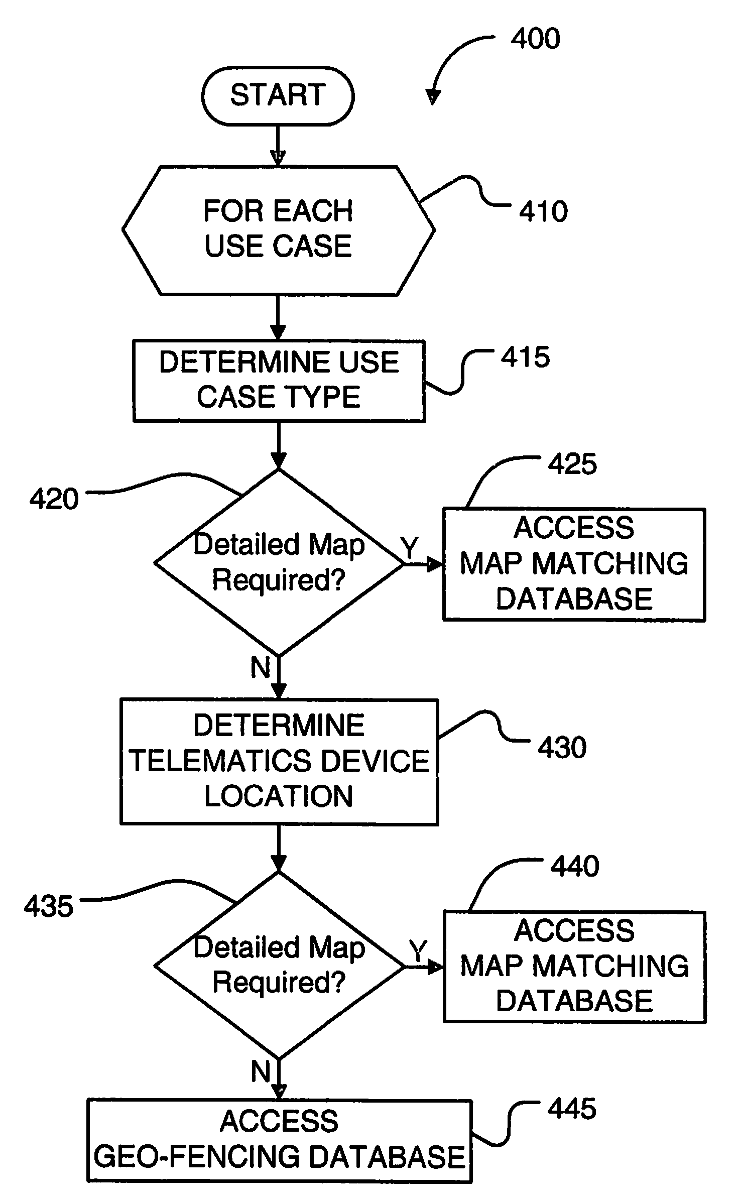
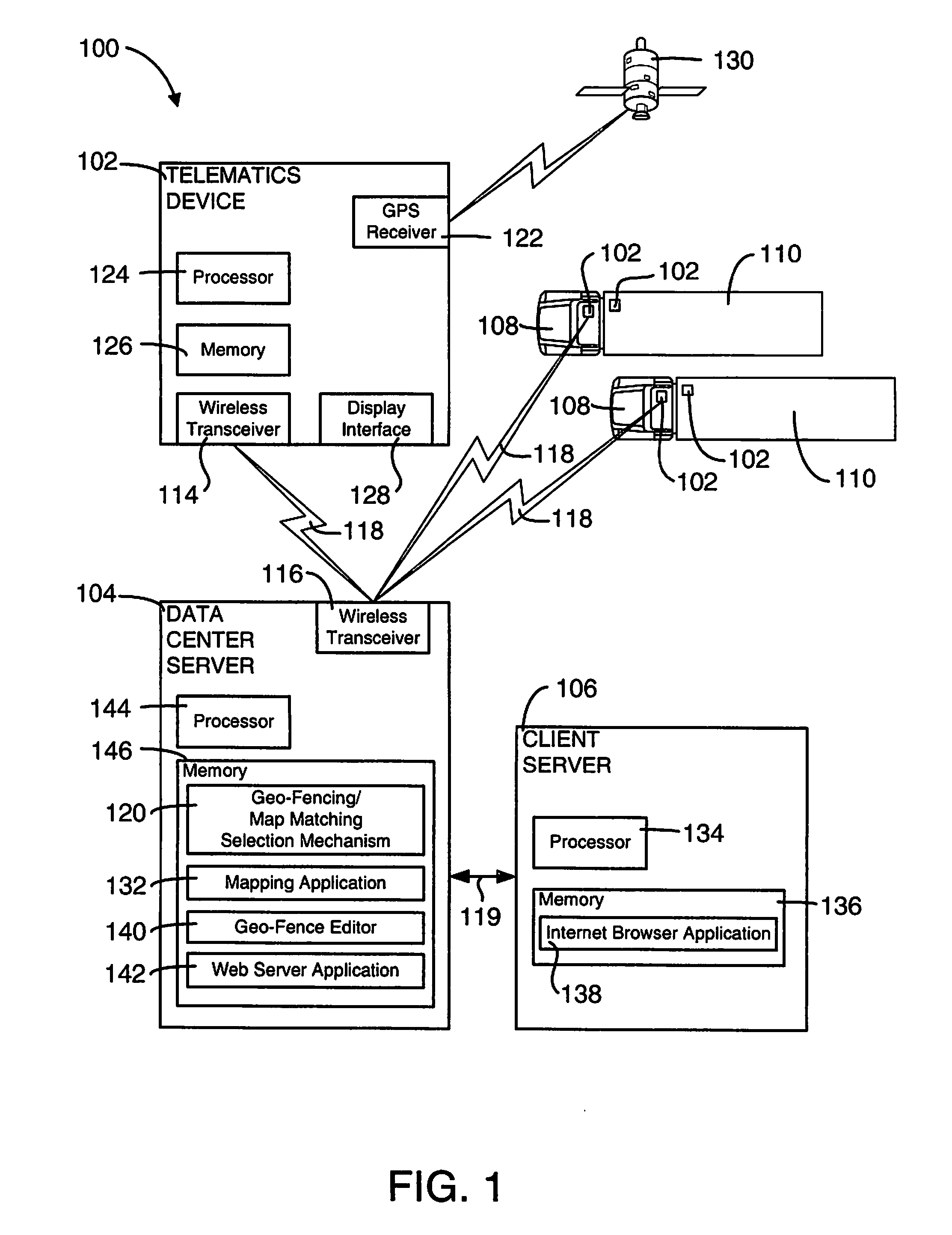
[0016]According to the preferred embodiments of the present invention, an enhanced mechanism intelligently selects between the utilization of geo-fencing and map matching in a telematics system. This geo-fencing / map matching selection mechanism determines for a use case at least one of a use case type and a telematics device location. If it is determined that the use case is a first use case type (e.g., fleet management) or the telematics device location is within a first region (e.g., a region without significant change), a geo-region map is utilized for geo-fencing. Otherwise, a vectorial map is utilized for map matching. Hence, in regions and / or use cases where detailed maps are not required, the geo-fencing / map matching selection mechanism can automatically utilize a geo-region map and thereby save on cost, both with regard to the cost of map licensing fees and the communications expenses necessary to provide detailed map updates to one or more telematics devices.

Problems solved by technology

Each vehicle in these fleets is subject to misuse or theft.
For example, it is likely that some vehicles in such a fleet will be the target of thieves or used by employees at unauthorized times or along unauthorized routes.
Moreover, the contents of a vehicle in such a fleet may be subject to misuse or theft, even if the vehicle itself is not misused or stolen.
For example, one or more large shipping containers which are transported on trucks, trains and ships may be stolen from that vehicle.
Problems often occur with the map matching when the precise location of the telematics device at any particular moment in time and space is inaccurate, or when the map data contain slight inaccuracies.
This advantageously reduces the amount of data required and the computing load for geo-fencing as compared to map matching, but at the cost of less accuracy.
The maps used in map matching are typically large data files that are expensive to create and maintain.
This expense relates to both the cost to buy or license the updated maps and the effort to provide the updated maps to the numerous telematics devices in the fleet.
Map updates alone can drive most telematics business models into the red when one factors in both the cost of map licensing fees and the cost of updating the telematics devices (e.g., the communications expense such as cellular service charges necessary to provide the updated maps to each of the devices in the fleet).
In other situations, however, map updates are less desirable and their additional cost cannot be justified.

Method used


Image

  • Method, Apparatus, and Computer Program Product for Intelligently Selecting Between the Utilization of Geo-Fencing and Map Matching in a Telematics System
  • Method, Apparatus, and Computer Program Product for Intelligently Selecting Between the Utilization of Geo-Fencing and Map Matching in a Telematics System
  • Method, Apparatus, and Computer Program Product for Intelligently Selecting Between the Utilization of Geo-Fencing and Map Matching in a Telematics System

Examples


Embodiment Construction

1.0 Overview

[0023]In accordance with the preferred embodiments of the present invention, an enhanced mechanism intelligently selects between the utilization of geo-fencing and map matching in a telematics system. This geo-fencing / map matching selection mechanism determines for a use case at least one of a use case type and a telematics device location. If it is determined that the use case is a first use case type (e.g., fleet management) or the telematics device location is within a first region (e.g., a region without significant change), a geo-region map is utilized for geo-fencing. Otherwise, a vectorial map is utilized for map matching. Hence, in regions and / or use cases where detailed maps are not required, the geo-fencing / map matching selection mechanism can automatically utilize a geo-region map and thereby save on cost, both with regard to the cost of map licensing fees and the communications expenses necessary to provide detailed map updates to one or more telematics devic...


PUM


Abstract

An enhanced mechanism for intelligently selecting between the utilization of geo-fencing and map matching in a telematics system. This geo-fencing / map matching selection mechanism determines for a use case at least one of a use case type and a telematics device location. If it is determined that the use case is a first use case type (e.g., fleet management) or the telematics device location is within a first region (e.g., a region without significant change), a geo-region map is utilized for geo-fencing. Otherwise, a vectorial map is utilized for map matching. Hence, in regions and / or use cases where detailed maps are not required, the geo-fencing / map matching selection mechanism can automatically utilize a geo-region map and thereby save on cost, both with regard to the cost of map licensing fees and the communications expenses necessary to provide detailed map updates to one or more telematics devices.

Description

BACKGROUND OF THE INVENTION[0001]1. Field of Invention[0002]The present invention relates in general to the digital data processing field and, in particular, to telematics systems. More particularly, the present invention relates to a mechanism for intelligently selecting between the utilization of geo-fencing and map matching in a telematics system.[0003]2. Background Art[0004]Businesses, governments and other organizations and entities often utilize one or more fleets of vehicles such as long-haul truck fleets, delivery truck fleets, emergency response vehicle fleets, utility vehicle fleets, maintenance vehicle fleets, taxi fleets, train fleets, aircraft fleets, ship fleets, and the like. Each vehicle in these fleets is subject to misuse or theft. For example, it is likely that some vehicles in such a fleet will be the target of thieves or used by employees at unauthorized times or along unauthorized routes. Moreover, the contents of a vehicle in such a fleet may be subject to mis...

Claims


Application Information

Patent Timeline
IPC IPC(8): G01C21/00G01S5/00G08B1/08H04Q7/00
CPCG08G1/20G01C21/30
Inventor HINES, JEFFERY SCOTTWIWEL, TIMOTHY M.
Owner IBM CORP
Learn More