Within the
aviation industry, a serious concern exists regarding the unauthorized entry of aircraft onto airport runways during taxiing operations, which is commonly referred to as a “runway incursion.” This concern has recently been heightened by a number of recent incidents involving “near-misses” occurring when two aircraft have attempted to use the same runway or intersecting runways at the same time, resulting in the potential for a disastrous collision.
In another recent incident, a commercial aircraft crashed during
takeoff, due to the fact that the
pilot had attempted to take off from the wrong runway, which was shorter than the minimum required
takeoff distance for the aircraft.
However, such systems are not well suited to prevent runway incursions at many of today's larger airports, which include many runways and taxiways where dozens of aircraft may be taxiing, taking off or landing at any given time.
Moreover, such systems are less reliable at night or during low-
visibility conditions, when the ability of pilots and air traffic controllers to monitor conditions visually is diminished.
While the alerting
system disclosed by U.S. Pat. No. 6,606,563 provides pilots with some notification of potential runway incursions, as described above, that system does not teach the use of a conventional electronic airport chart to display a graphical depiction of the present position of an aircraft, relative to the runway of interest and other geographical features of the airport.
Thus, while the
pilot may understand that he is approaching a runway, he may not immediately realize where the runway is located relative to his aircraft or which way he should proceed to avoid entering the runway—particularly if he is operating at an airport with which he is unfamiliar.
Moreover, if the
pilot has entered a runway different from the runway on which the aircraft has been cleared to take off, he may not be cognizant of that fact based solely on an audible warning or a visual designation such as “
RUNWAY appearing on a display screen.
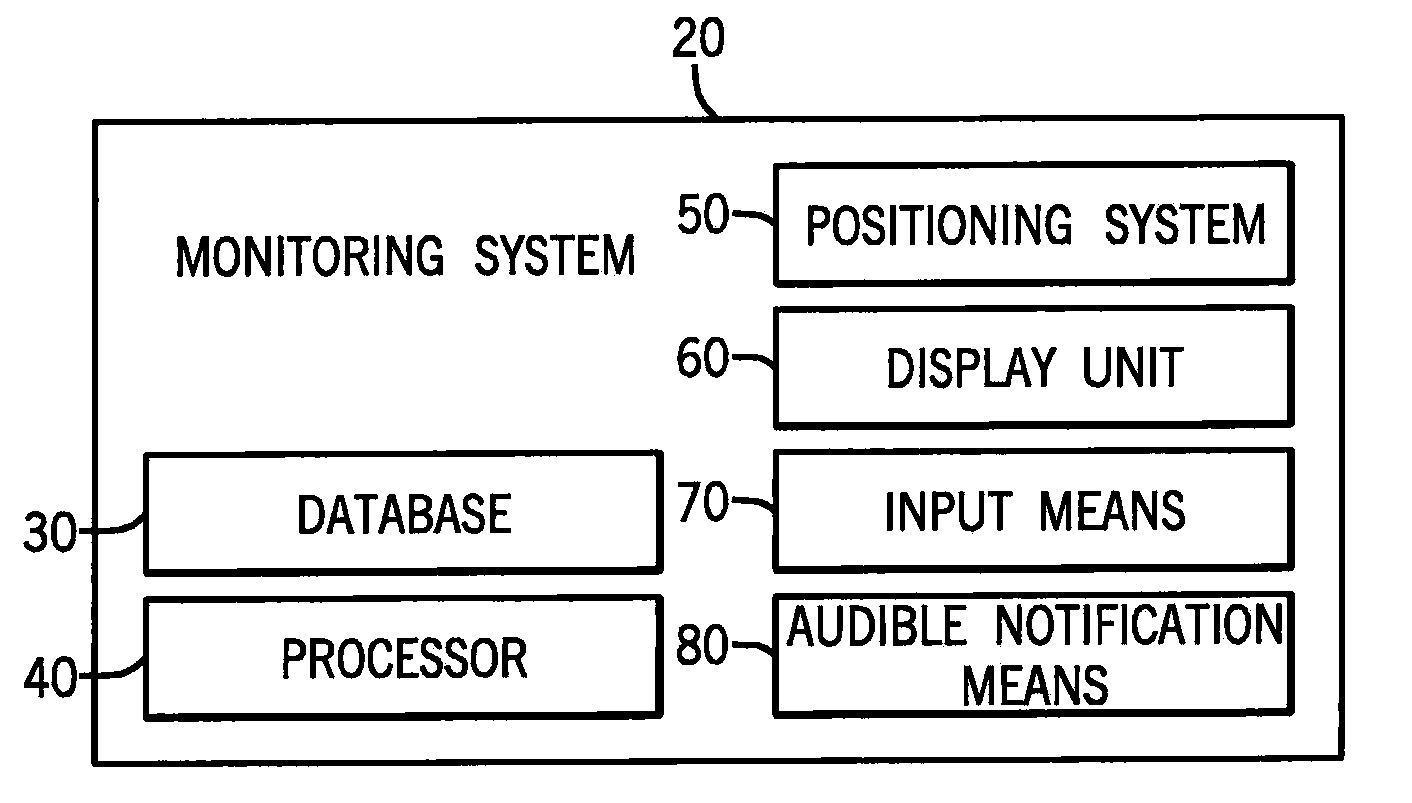
However, EFB systems, and particularly those systems which are not capable of receiving data from the aircraft's
avionics systems, have limited capability of notifying the flight
crew of potential runway incursions, as they typically have limited or no capability of obtaining data regarding the aircraft's position and velocity, for display on an airport charts stored within the
database.
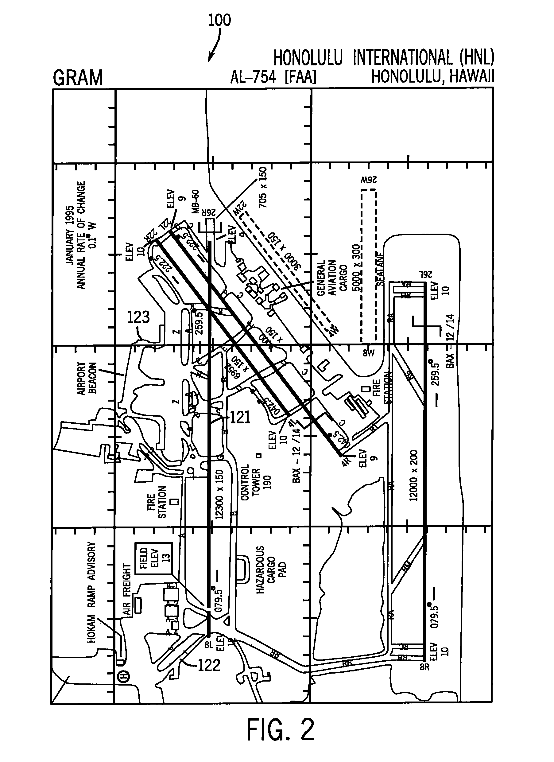
Standard airport charts, while useful for providing general position information, were previously limited by the fact that positional coordinates on the charts were not indexed to a fixed global
reference frame, such as the WGS 84, which is the reference system used by the
Global Positioning System (GPS).
As a result, such charts were likely to generate
significant error between the actual position of the aircraft relative to airport geographical features, as determined by GPS, and the aircraft position displayed on the airport chart, because the positional coordinates on those charts were not based on WGS 84.
Thus, such charts were simply not capable of displaying the position of an aircraft with sufficient accuracy to identify potential runway incursions.
As a result, a position of an aircraft determined using GPS can be displayed on a geo-referenced airport chart with an accuracy unobtainable using standard, non-geo-referenced airport charts.
This could result in either a false notifications of a potential runway incursion, or a failure to notify the pilot of an actual potential runway incursion.
However, while the SAMM system is capable of warning a pilot of potential incursions by other aircraft onto a runway being used by his aircraft, and highlighting the position of both aircraft on an electronic airport chart, it does not provide the pilot with any notification prior to his own aircraft entering onto the runway in the first place.
While systems such as those disclosed above are capable of alerting pilots to potential runway incursions under certain circumstances, they each have significant limitations.

