Method of constructing panoramic electronic map service

Inactive Publication Date: 2009-05-07
LIU XIAOHUA +2
View PDF5 Cites 26 Cited by
  • Summary
  • Abstract
  • Description
  • Claims
  • Application Information

AI Technical Summary

Benefits of technology

[0014]In order to realize the above objective, provided is also a method of constructing a panoramic electronic map service capable of providing detailed, specific, and live map searching service. In certain embodiments of the invention, by collecting continuous panoramic image sequence containing position information, the panoramic image is associated with an electronic map via positional information. Since the panoramic image is capable of expressing the entire space information, and two adjacent images have a certain degree of overlap, the user can understand and appreciate in a straightforward manner positional situation at a searched point and the surrounding areas enabling the user to make accurate and clear judgments and decision.In certain embodiments of the invention, a method of constructing panoramic electronic map service of the invention comprises the steps of: 1) collecting a panoramic image sequence, namely, a collecting panoramic image sequence containing geographic position information and having a previous and next image information continuity;
[0021]As a result, since the panoramic service function is added to a conventional map service, the user can obtain the searching results with continuous panoramic information when searching for any street or community position within the areas containing panoramic resource.

Problems solved by technology

However, by utilizing conventional electronic map services, a user can only get position information related to the searching point but is not given any additional necessary and useful details.
However, the expression form of the panoramic image in a conventional electronic map service is difficult to fit the requirements of a user.
However, since the information collection is limited, the panoramic image of the searching position cannot be seen by most of the users, and the expression form of the panoramic image is passive.
Meanwhile, the above panoramic image does not provide any position information, the name must be associated with the address, or the panoramic image has to be positioned onto the electronic map by marking the electronic map.
If the quantity of the panoramic image reaches a certain amount, the searching capacity will be overloaded, the searching efficiency will be low, and the searching operability will be limited.
However, since the user is not familiar with the name, the searching experience is not attractive.
If the association is realized by marking on the electronic map, since the position sense of the scaled streets on the electronic map is weak, it is difficult for the user to position the collected panoramic image to the electronic map by naked eye, influencing negatively the searching experience.
Besides, in a conventional searching mode, there is no overlap between the panoramic images, the user cannot see information close to the panoramic image when searching, and the information obtained is not continuous.
In fact, a conventional searching mode cannot provide much actual help for people's daily lives.
It is too far to satisfy the user's searching requirement by providing the panoramic images only for some sceneries and asking the user to search for concerned information within these panoramic images.

Method used


Image

  • Method of constructing panoramic electronic map service
  • Method of constructing panoramic electronic map service
  • Method of constructing panoramic electronic map service

Examples


Embodiment Construction

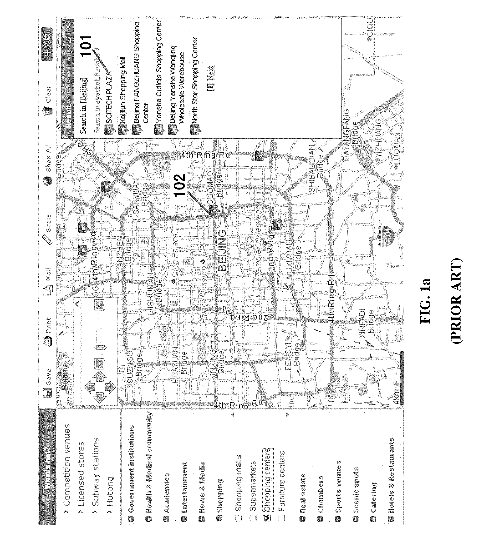
[0030]FIG. 1 illustrates a conventional electronic map service mode and an electronic map expression mode with the addition of panoramic image. Specifically, FIG. 1a illustrates a searching result screen shot for a searching area of Beijing and a searching word of business center based on a conventional electronic map service. Area 101 expresses the text searching results. Area 102 shows the positions of the searching results on the electronic map. The numbers in areas 101 correspond to the marks in areas 102, expressing that the geographic position shown in area 102 is the position shown by the number in area 101.

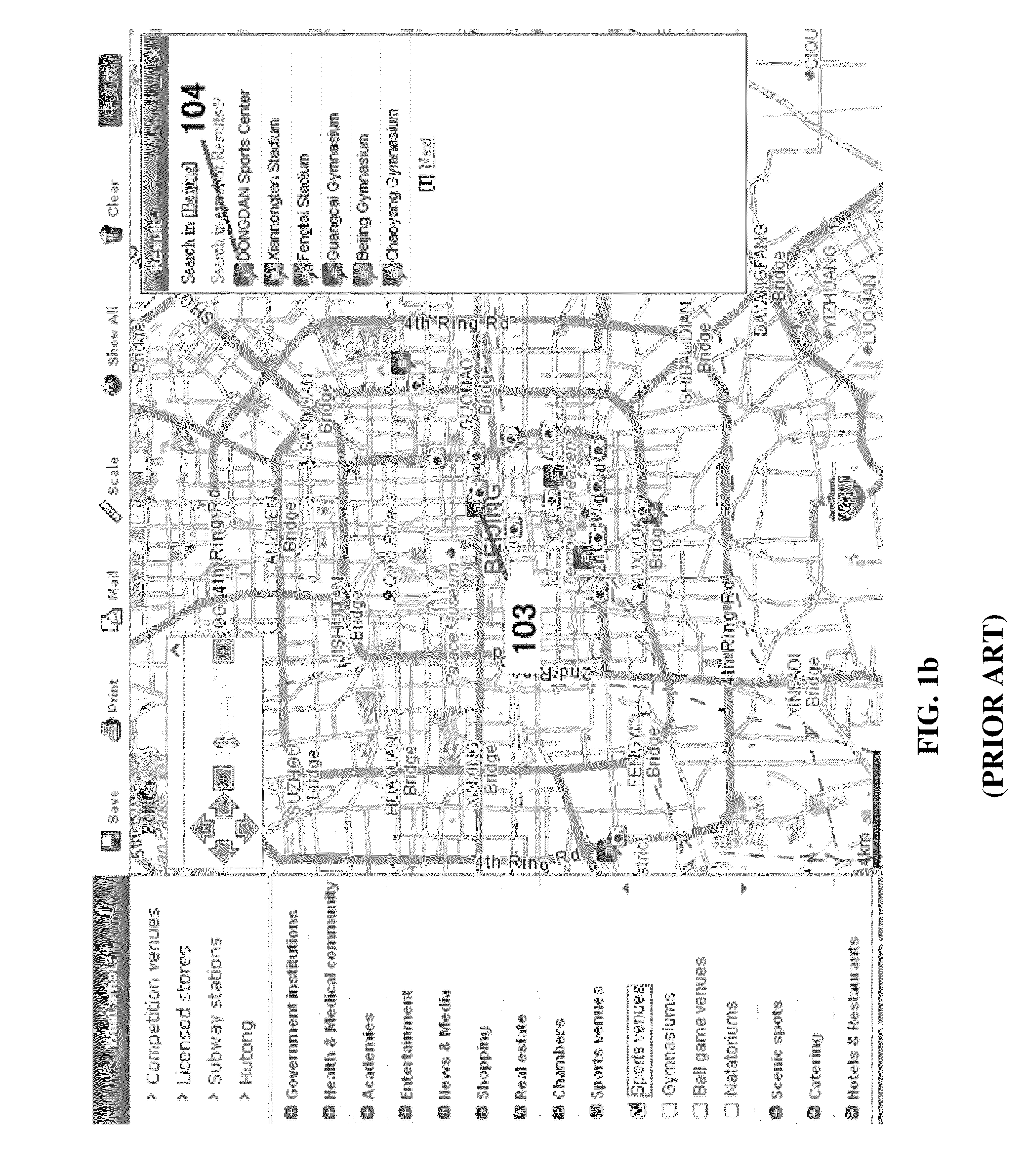
[0031]FIG. 1b illustrates an expression mode of a conventional electronic map with the addition of panoramic image. Area 104 expresses the position name having panoramic images. Area 103 illustrates a camera list diagram in the electronic map. Each camera point means that the point contains panoramic image. From the quantity of the cameras, it can be seen that the quantity...


PUM


Abstract

A method of constructing panoramic electronic map service, comprising the steps of: 1) collecting panoramic image sequence, namely, collecting panoramic image sequence containing geographic position information and having information continuity between adjacent images; 2) establishing panoramic image database, namely, establishing database containing a panoramic image sequence on a server; 3) establishing position association link, namely, associating the panoramic image sequence in the database with the electronic map via position information; and 4) searching and positioning the panoramic image, namely, when searching, a user can position the geographic information at a searched point on the electronic map by searching for a keyword, and find the corresponding position information in the panoramic image sequence so as to retrieve the panoramic image. The method of the invention can be applied to a conventional electronic map service so as to provide more detailed, specific, and omnidirectional position information.

Description

CROSS-REFERENCE TO RELATED APPLICATIONS[0001]This application is a continuation of International Patent Application No. PCT / CN2007 / 001076, with an international filing date of Apr. 3, 2007, designating the United States, now pending, which is based on Chinese Patent Application Numbers 200610026274.3 filed on Apr. 29, 2006, 200610027218.1 filed on Jun. 1, 2006, 200610027219.6 filed on Jun. 1, 2006 and 200610027657.2 filed on June 13, the contents of these specifications are incorporated herein by reference.BACKGROUND OF THE INVENTION[0002]1. Field of the Invention[0003]The invention relates to methods for constructing electronic map service, and especially, to a method of constructing panoramic electronic map service with which the user can inquire and obtain a 360 degree panoramic information.[0004]2. Description of the Related Art[0005]In recent years, online map searching services became popular. Conventional searching service providers, such as Google, MSN, Yahoo, Sina, Baidu, a...

Claims


Application Information

Patent Timeline
IPC IPC(8): G06K9/36G06T17/05
CPCG06T3/4038H04N5/262H04N5/23238H04N23/698
Inventor LIU, XIAOHUAXIE, DONGFANGHU, XIAOFENG
Owner LIU XIAOHUA
Why Eureka
Try Eureka