Geocoding based on neighborhoods and other uniquely defined informal spaces or geographical regions

a technology of informal spaces and geocoding, applied in the field of geographical information systems and online searching of data structures with geographical indexing, can solve problems such as surprise to users, and achieve the effect of facilitating the determination of “winning”

Inactive Publication Date: 2009-05-21
URBAN MAPPING
View PDF27 Cites 143 Cited by
  • Summary
  • Abstract
  • Description
  • Claims
  • Application Information

AI Technical Summary

Benefits of technology

[0013]In some cases, the neighborhood definition information includes more than one boundary geometry or definition for the same neighborhood, and the generating of the boundary definition for such neighborhoods includes combining the two boundaries to define a single, new boundary geometry. For example, the new boundary geometry may be a polygon (e.g., defined by geographic coordinates such as three or more latitude and longitude pairs) that is selected to include at least all of the area enclosed or included in the combined boundary definitions. In many cases, there is overlap between the combined definitions and also non-common area(s) or areas unique to one of the combined definitions. The generating of the boundary step may in some embodiments include modifying the boundary geometry to define a new boundary geometry (e.g., by increasing the size of the original boundary to include more area such as by moving all boundary edges outward a preset distance, enlarging the area a particular percentage or preset area amount, or by moving one or more of the defining geographic coordinates to include more area).
[0014]During the generating of the boundaries step, the computer is allowed to create boundaries that cross such that there is a common or overlapping area between two or more of the neighborhoods, and the method in these cases will include assigning weights to the neighborhoods or providing a dominance relationship between these overlapping neighborhoods to facilitate determining a “winning” or “matching” neighborhood for locations or positions within the overlapping area (e.g., when only one neighborhood can be considered to contain a geographic location, it is the dominant or more heavily weighted neighborhood). The method may further include generating a geocoded database by associating each of the neighborhoods with a set of digital content. In using the geocoded database, the method may include responding to a search request or user's query that includes a geographic term and a content term by associating the geographic term with one of the neighborhoods and returning a portion of the digital content associated with that neighborhood back as a search result. For example, the geographic term may include a neighborhood name that can be matched to one of the neighborhood names in the data structure or may include a geographic location corresponding to the boundary definition of one of the neighborhoods.

Problems solved by technology

When a neighborhood name is entered as a search term, the results are often surprising to the user with unwanted matches or hits and desired entities not providing a match or being missed.

Method used


Image

  • Geocoding based on neighborhoods and other uniquely defined informal spaces or geographical regions
  • Geocoding based on neighborhoods and other uniquely defined informal spaces or geographical regions
  • Geocoding based on neighborhoods and other uniquely defined informal spaces or geographical regions

Examples


Embodiment Construction

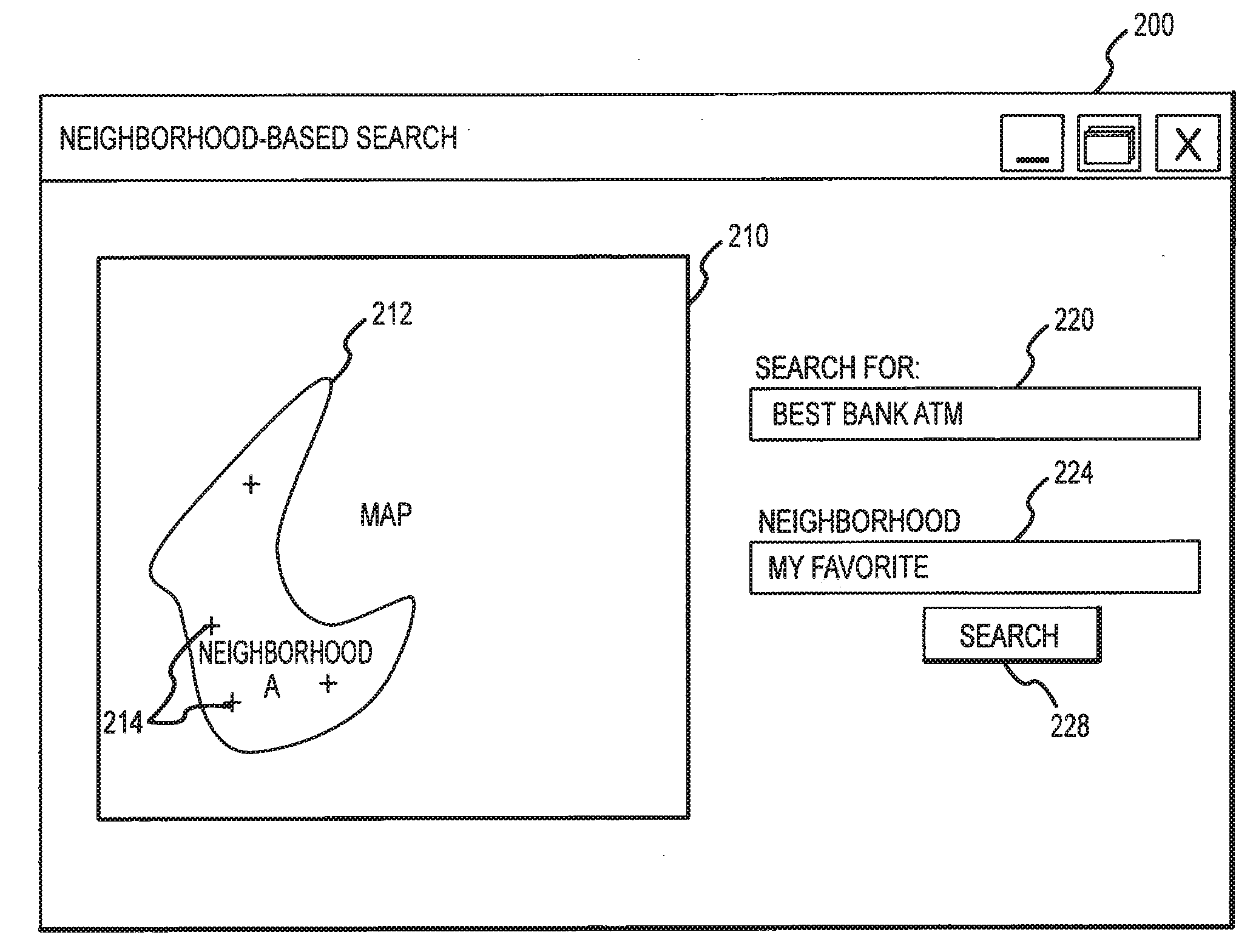
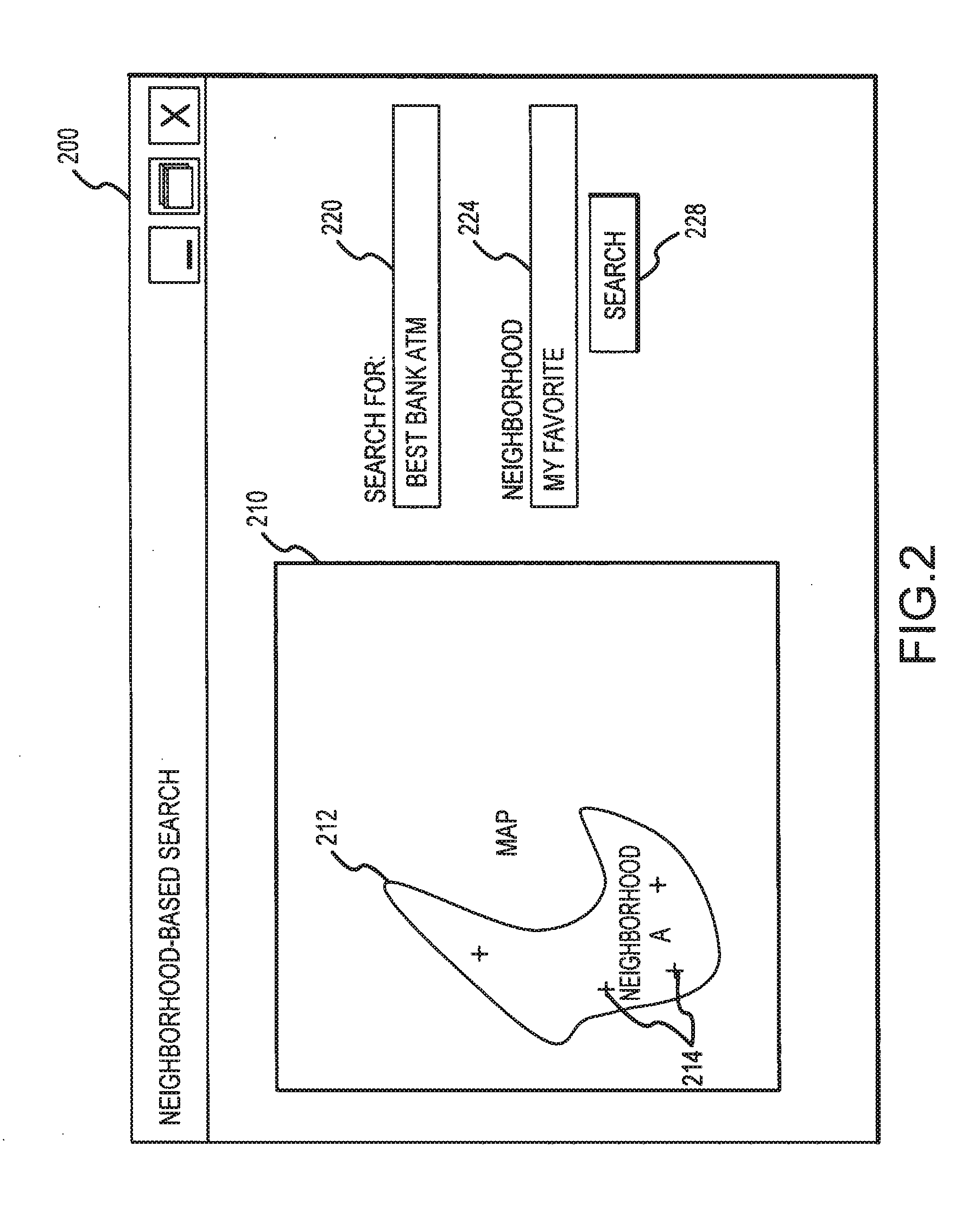
[0025]The present invention is directed to methods and systems for creating a data structure that includes unique definitions of geographic regions such as informal spaces and particularly including neighborhoods. The data structure is created by establishing a more inclusive (e.g., generally larger) definition of each neighborhood in a particular geographic region. Interestingly, the method specifically allows the definitions to overlap (and such overlap may be intentionally created as part of the boundary definition process) to provide a neighborhood mapping or organization that better correlates with users' concepts and beliefs about neighborhoods. For example, two boundary definitions may be identified for a single neighborhood, and a new boundary definition may be generated by an additive process of the two definitions. With the new boundary definition, additional data may be gathered and stored in the data structure such as the neighborhoods relationships to other geographic r...


PUM


Abstract

A computer-based method for creating a data structure for informal geographic spaces for use with geocoded databases. A set of data is stored in memory for a geographic region, and a plurality of neighborhoods is identified in the geographic region based on processing of the stored set of data. The method includes generating a boundary definition for each of the neighborhoods by processing neighborhood definition information. A data structure is created in the memory for containing neighborhood data content with at least one record for each of the neighborhoods. The data structure is populated by storing, for each neighborhood, the generated boundary definition along with a neighborhood name and identifier in the records of data structure. The boundary definition may be created by combining two or more definitions identified for a single neighborhood to provide a more inclusive geometry such as by aligning the geometries and performing an additive algorithm.

Description

BACKGROUND OF THE INVENTION [0001]1. Field of the Invention[0002]The present invention relates, in general, to geographical information systems and on-line searching of data structures with geographical indexing such as geocoded databases, and, more particularly, to computer software, hardware, computer-based methods, and related data structures used for supporting data searches, such as may be performed via an Internet search engine, that include at least one geographical search term.[0003]2. Relevant Background[0004]One of the most common and growing uses of the Internet is to perform local or geographic based searches. For example, a user may search for hotels near an airport or in a particular city, search for a restaurant that serves a particular type of cuisine near a particular location, or search for a library near their home. The user typically will simply access a search engine provided by any of a number of on-line service providers and enter search terms that include a g...

Claims


Application Information

Patent Timeline
Patent Type & Authority Applications(United States)
IPC IPC(8): G06F17/30G06Q10/00
CPCG06Q10/00
Inventor WHITE, IAN H.FAZAL, RIYAZ
Owner URBAN MAPPING
Why Eureka
Try Eureka