System and Method for Extending GPS to Divers and Underwater Vehicles

a technology for underwater vehicles and gps navigation, applied in the field of underwater navigation, can solve the problems of limited utility, buoys not staying in place, and underwater vehicles beneath the water's surface are not able to utilize gps signals to navigate accurately, etc., and achieve the effect of effectively extending gps to underwater

Inactive Publication Date: 2009-06-04
ESTATE OF ALBERT R BASILICO
View PDF75 Cites 70 Cited by
  • Summary
  • Abstract
  • Description
  • Claims
  • Application Information

AI Technical Summary

Benefits of technology

[0005]The present invention provides an underwater navigation system that effectively extends GPS to underwater users and devices. The present invention could also be used to provide navigation signals to surface moving vessels. The underwater navigation system comprises a plurality of sub-surface beacon units that are designed to sink to the ocean bottom and at least one location reference unit that is designed to initialize the beacon units with their location. The beacon units and the location reference unit are positioned in an area where navigation assistance is needed. The beacon units sink immediately to the ocean bottom. In some embodiments, the location reference unit determines its location and transmits its locat

Problems solved by technology

Consequently, divers and underwater vehicles beneath the water's surface are not able utilize these GPS signals to navigate accurately.
This solution is limited in utility by the need for a tether connecting the underwater diver o

Method used


Image

  • System and Method for Extending GPS to Divers and Underwater Vehicles
  • System and Method for Extending GPS to Divers and Underwater Vehicles
  • System and Method for Extending GPS to Divers and Underwater Vehicles

Examples


Embodiment Construction

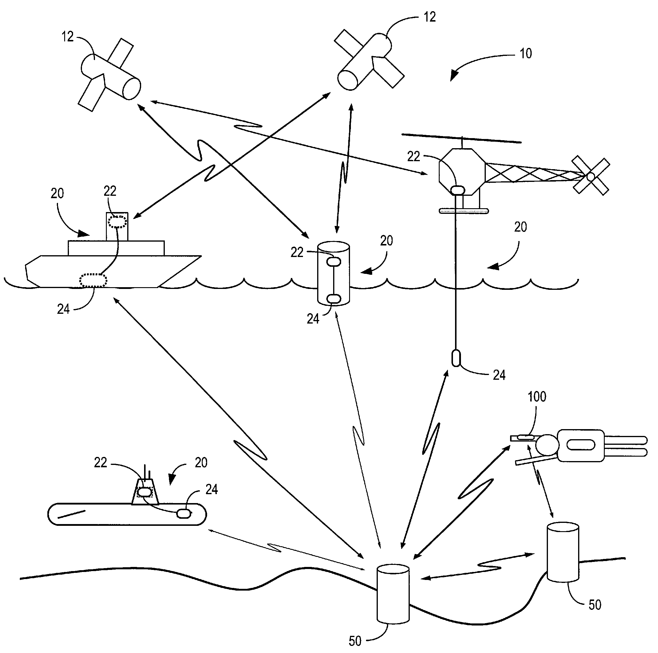
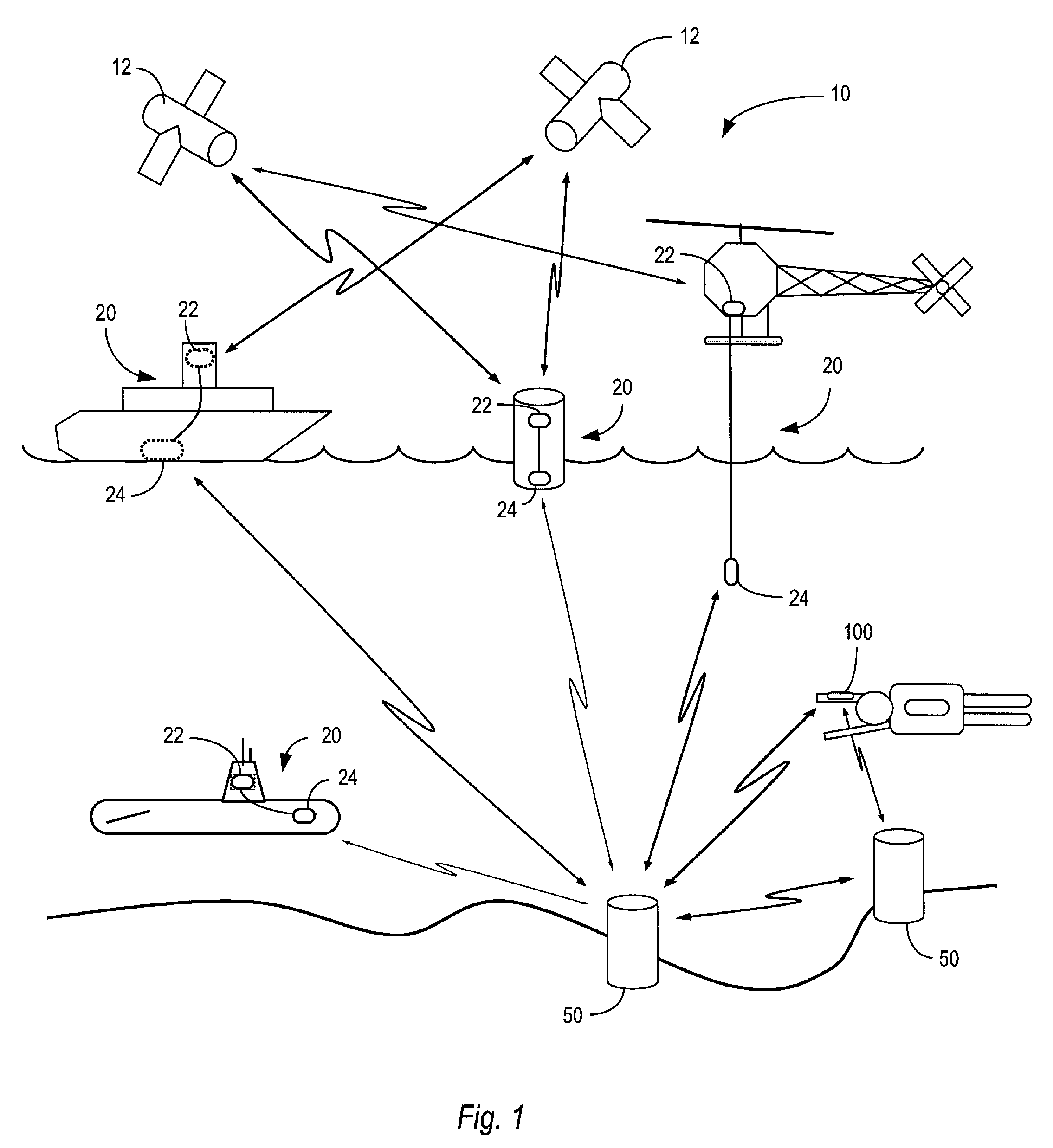
[0010]FIG. 1 illustrates an underwater navigation system indicated generally by the numeral 10 according to one exemplary embodiment. The underwater navigation system 10 provides navigation assistance to a diver, underwater vessel, or surface vessel, which are referred to herein generically as guided units 100. The underwater navigation system 10 comprises two main components: one or more location reference units 20 and a plurality of beacon units 50. The location reference unit 20 provides a reference location for the beacon units 50 while the beacon units 50 are being deployed and initialized. When deployed, the beacon units 50 sink below the surface and anchor to the floor. Once the beacon units 50 are anchored, the beacon units 50 determine their respective locations based on the distance of the beacon unit 50 from one more location reference units 20. After being initialized, the beacon units 50 provide navigation assistance to the guided units 30.

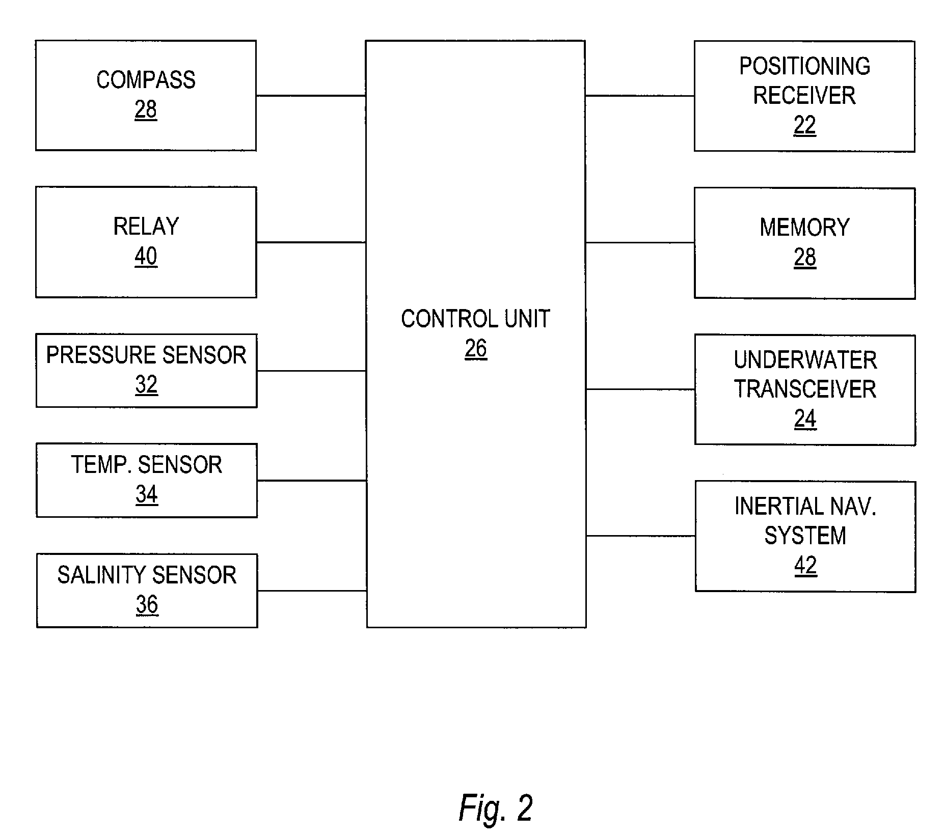
[0011]FIG. 2 illustrates the m...


PUM


Abstract

A navigation system extends satellite navigation to divers, underwater vehicles, and surface vessels. The navigation system comprises a location reference unit and a plurality of sub-surface beacon units. The location reference unit includes a receiver to receive navigation signals from earth-orbiting satellites and/or an inertial navigation system. The location reference unit further includes control circuits to communicate with to sub-surface beacon units and to transmit location information to said sub-surface beacon units, and a transceiver to transmit location information to the sub-surface beacon units. The beacon units include control circuits to determine the location of the beacon unit based on location information received from the location reference unit, and a transceiver to receive location information from the location reference unit and to transmit location information to a guided unit to provide navigation assistance to the guided unit.

Description

RELATED APPLICATION[0001]This application is a continuation-in-part and claims the benefit of U.S. patent application Ser. No. 11 / 856,449 filed Sep. 17, 2007 titled “System And Method For Extending GPS To Divers And Underwater Vehicles,” which is a continuation-in-part of U.S. patent application Ser. No. 11 / 182,894 filed Jul. 15, 2005 titled “System And Method For Extending GPS To Divers And Underwater Vehicles,” now U.S. Pat. No. 7,272,074. Both of these applications are incorporated herein by reference in their entireties.BACKGROUND OF THE INVENTION[0002]The present invention relates generally to underwater navigation and, more particularly, to a method and apparatus for extending GPS navigation to divers and underwater vehicles.[0003]Satellite-based positioning systems, such as the Global Positioning System (GPS), provide the ability to accurately determine location virtually almost anywhere on or above the Earth's surface. The GPS system comprises 24 earth-orbiting satellites lo...

Claims


Application Information

Patent Timeline
IPC IPC(8): G01S3/80G01C21/00
CPCG01S1/72G01S1/74G01S15/74G01S3/8083G01S5/30G01S1/80G01S1/75
Inventor BASILICO, ALBERT R.
Owner ESTATE OF ALBERT R BASILICO
Why Eureka
Try Eureka