System and method for using a satellite positioning system to filter WLAN access points in a hybrid positioning system

a satellite positioning system and access point technology, applied in direction finders, instruments, measurement devices, etc., can solve problems such as strengths and weaknesses of approaches

Active Publication Date: 2009-12-10
SKYHOOK WIRELESS
View PDF100 Cites 87 Cited by
  • Summary
  • Abstract
  • Description
  • Claims
  • Application Information

AI Technical Summary

Benefits of technology

[0032]HPE estimation device 209 estimates the expected error of the estimated location. The HPE estimation device 209 is conventional and calculates expected error based on geometry of the satellites and signal quality of the received signal from satellites, for example, DOP (dilution of precision), and C / N (carrier to noise ratio).

Problems solved by technology

Each of these approaches has its strengths and weaknesses, depending upon the nature of the signals and measurements, and the positioning algorithms employed.

Method used


Image

  • System and method for using a satellite positioning system to filter WLAN access points in a hybrid positioning system
  • System and method for using a satellite positioning system to filter WLAN access points in a hybrid positioning system
  • System and method for using a satellite positioning system to filter WLAN access points in a hybrid positioning system

Examples


Embodiment Construction

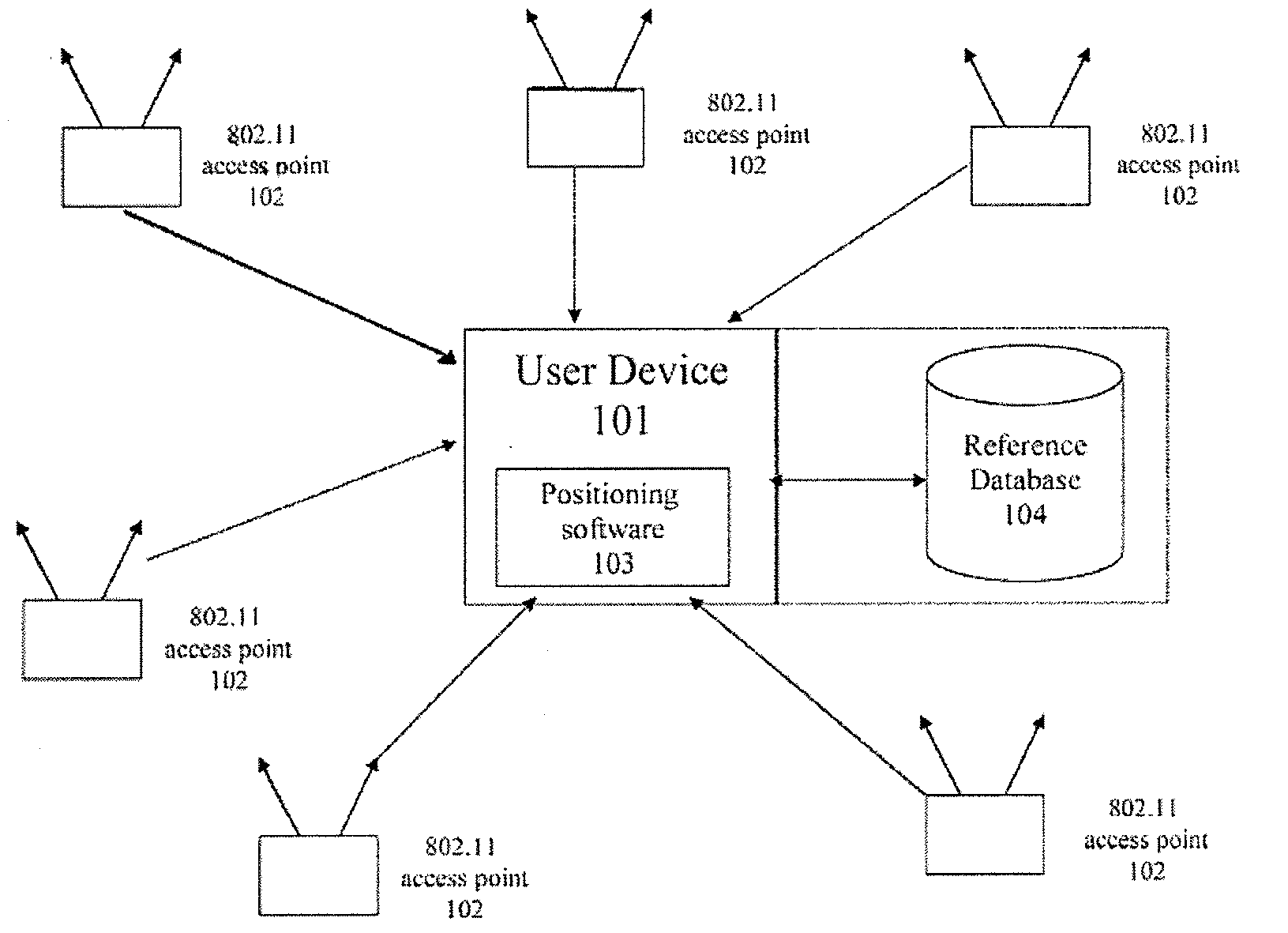
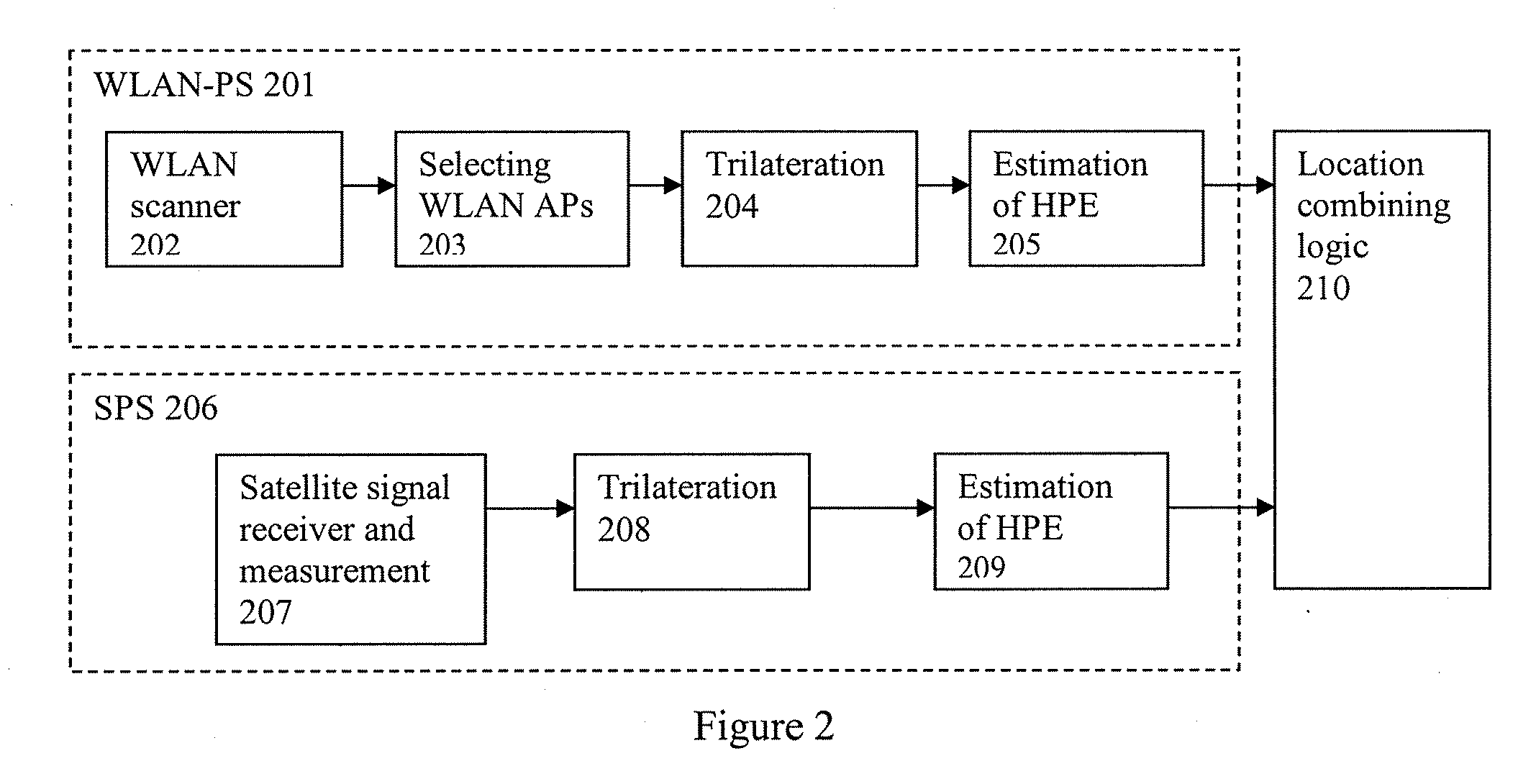
[0065]Embodiments of the disclosed subject matter provide a method of integrating a WLAN-based positioning system (WLAN-PS) and a satellite-based positioning system (SPS) to create a hybrid positioning system. An integrated or hybrid system refers to a system which combines the measurements from one or more systems to improve the accuracy of the positioning and velocity and bearing estimates and the accuracy of expected error estimate, and to reduce consumed power as compared to each individual system working independently. The method of integrating a WLAN-PS and SPS to create a hybrid positioning system can add raw SPS measurements as another input to WLAN-PS and WLAN-PS final estimations as another input to SPS. Raw SPS measurements from two or more satellites can assist the WLAN-PS to increase the accuracy of position estimate, HPE, and stationary user detection. WLAN-PS initial position estimate and other estimations also can help SPS to reduce time to first fix (TTFF) and power...


PUM


Abstract

This disclosure describes a system and method for using a satellite positioning system to filter WLAN access points in a hybrid positioning system. In some embodiments, the method can include detecting WLAN APs in range of the WLAN and satellite enabled device, obtaining satellite measurements from at least two satellites to provide a plurality of possible satellite locations of the device, and providing a weight for each AP based on the distance from the WLAN APs to the possible satellite locations of the device.

Description

CROSS-REFERENCE TO RELATED APPLICATIONS[0001]This application claims the benefit under 35 U.S.C. §119(e) of U.S. Provisional Application No. 61 / 059,580, filed on Jun. 6, 2008, entitled Integrated WLAN-based and Satellite-based Positioning System, which is herein incorporated by reference in its entirety.[0002]This application is related to the following references:[0003]U.S. patent application Ser. No. (TBA), filed concurrently herewith and entitled “Method and System for Determining Location Using a Hybrid Satellite and WLAN Positioning System by Selecting the Best WLAN-PS Solution;”[0004]U.S. patent application Ser. No. (TBA), filed concurrently herewith and entitled “Systems and methods for Using Environmental Information in a Hybrid Positioning System;”[0005]U.S. patent application Ser. No. (TBA), filed concurrently herewith and entitled “Systems and Methods for Maintaining Clock Bias Accuracy in a Hybrid Positioning System;”[0006]U.S. patent application Ser. No. (TBA), filed co...

Claims


Application Information

Patent Timeline
Patent Type & Authority Applications(United States)
IPC IPC(8): G01S1/00
CPCG01S5/0257G01S19/48G01S19/46G01S19/34H04W64/00G01S19/31G01S5/14
Inventor ALIZADEH-SHABDIZ, FARSHID
Owner SKYHOOK WIRELESS
Why Eureka
Try Eureka