Accuracy and performance of a hybrid positioning system

a hybrid positioning and accuracy technology, applied in the field of hybrid positioning, can solve the problems of inaccurate range estimation, inability to use hybrid positioning, and difference between the receiver clock and the satellite clock, and achieve the effect of faster and relatively more accurate final estimate, accurate final location estimate, and more accurate results

Active Publication Date: 2014-01-28
SKYHOOK WIRELESS
View PDF254 Cites 15 Cited by
  • Summary
  • Abstract
  • Description
  • Claims
  • Application Information

AI Technical Summary

Benefits of technology

[0027]The following description describes a method in hybrid positioning systems to remove satellites with erroneous range estimates from the process of estimation of receiver location. The remaining satellites can then be used to estimate the location of the receiver by the hybrid positioning system which results in more accurate results. Once hybrid positioning system decides on using SPS measurements to refine the IEL, the disclosure describes a method to obtain a more accurate final location estimate using an aggregate of locations with sufficiently small SPS receiver clock bias variation. The following description also describes a method in hybrid positioning to assess the quality of current set of satellites and remove a set of satellites with erroneous range estimate from the process of location estimation. The outcome of the process will determine if the IEL should be used for positioning the receiver location or SPS reported location. The following disclosure also describes a method in hybrid positioning to obtain a faster and relatively more accurate final estimate of the receiver location using two-dimensional searches (referred to as 2D-searches) in each XY, XZ, and YZ planes and combining the results of each of 2D-searches to find the final estimate of the receiver location. The present disclosure also relates to hybrid positioning and more specifically, describes a new method to refine the initial estimated location (IEL) and obtain an improved estimate of the receiver location. In order to so, the method includes a proposal for the removal of satellites with erroneous range estimates from the current set of visible satellites.

Problems solved by technology

The lack of synchronization between the satellite clock and the receiver (user device) clock can result in a difference between the receiver clock and the satellite clock, which is referred to as internal SPS receiver clock bias or receiver clock bias.
However, some satellites experience multipath and their range estimates are too inaccurate for use in hybrid positioning.

Method used


Image

  • Accuracy and performance of a hybrid positioning system
  • Accuracy and performance of a hybrid positioning system
  • Accuracy and performance of a hybrid positioning system

Examples


Embodiment Construction

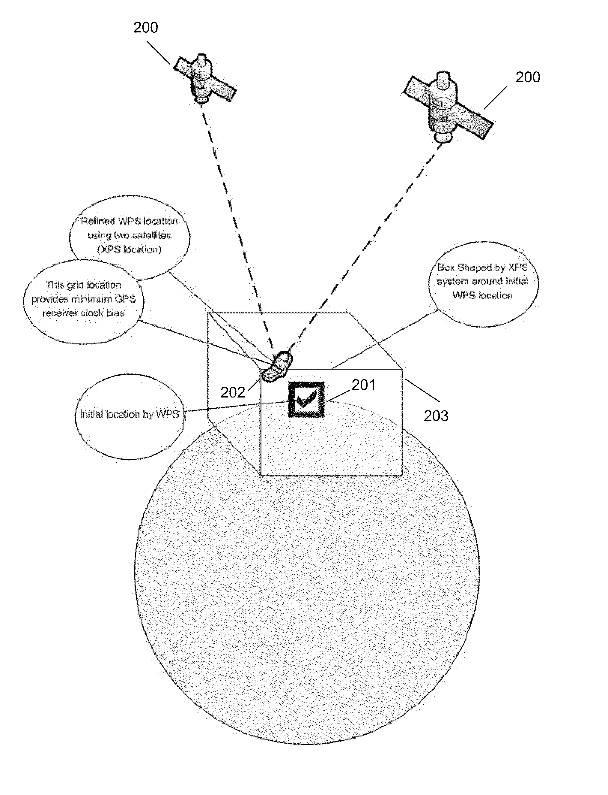
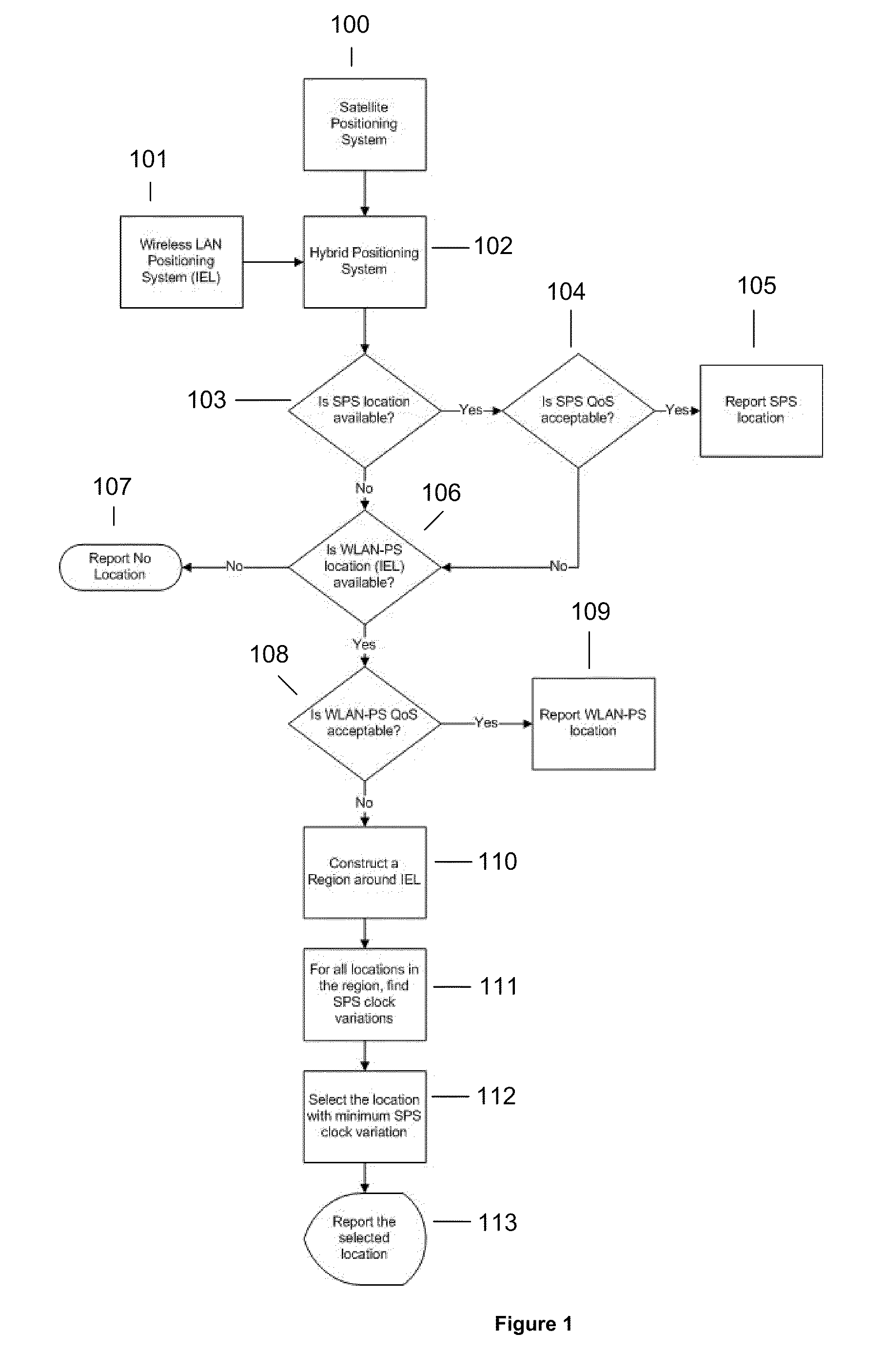
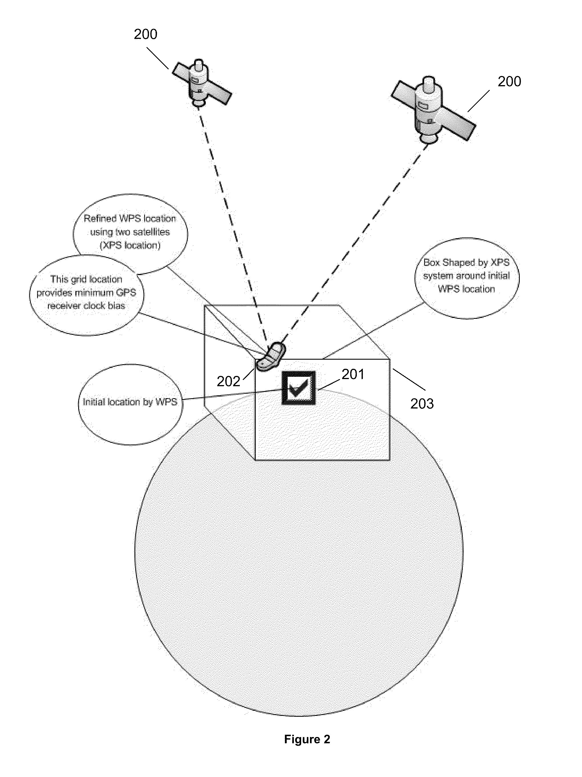
[0044]The following disclosure relates to systems and methods for evaluating the quality of either a set of satellites or individual satellites in a hybrid positioning system. The quality of the set satellites is evaluated using receiver clock bias. In that capacity, a high quality set of satellites is the one that satellites show consistency in predicting receiver clock bias. For that matter, all the estimations of receiver clock bias from different satellites should be close to one another. On the other hand, a bad quality set of satellites is the one that shows large variations when receiver clock bias is estimated for all satellites. In order to determine receiver clock bias for each satellite, the WLAN positioning system, in the hybrid system, provides an IEL and a region of error around that IEL. The shape and size of the region of error is based on IEL and its accuracy and hence this region relates to the quality of the IEL measurement (QoS). The IEL and the region of error c...


PUM


Abstract

The present disclosure relates to a method for determining the position of a WLAN positioning system (WPS) and satellite positioning system (SPS) enabled device. The method can include determining an initial WPS position of the device using WPS, calculating an error region around the initial WPS position of the device, dividing the error region into a plurality of points, obtaining satellite measurements from at least two satellites in view of the device, determining a variation in a receiver clock bias for each point within the error region based on the satellite measurements from at least two satellites, selecting the point with the lowest variation in the receiver clock bias, and determining whether or not to use the point with the lowest variation in receiver clock bias to refine the initial WPS position of the device.

Description

CROSS-REFERENCE TO RELATED APPLICATIONS[0001]This application is related to the following references:[0002]U.S. patent application Ser. No. 12 / 479,721, filed Jun. 5, 2009 and entitled “Systems and methods for Using Environmental Information in a Hybrid Positioning System;”[0003]U.S. patent application Ser. No. 12 / 479,722, filed Jun. 5, 2009 and entitled “Systems and Methods for Maintaining Clock Bias Accuracy in a Hybrid Positioning System;”[0004]U.S. patent application Ser. No. 12 / 479,723, filed Jun. 5, 2009 and entitled “System and Method for Refining a WLAN-PS Estimated Location Using Satellite Measurements in a Hybrid Positioning System;”[0005]U.S. patent application Ser. No. 12 / 479,724, filed Jun. 5, 2009 and entitled “Systems and Methods for Determining Position Using a WLAN-PS Estimated Position as an Initial Position in a Hybrid Positioning System;”[0006]U.S. patent application Ser. No. 12 / 479,727, filed Jun. 5, 2009 and entitled “Methods and Systems for Improving the Accura...

Claims


Application Information

Patent Timeline
Patent Type & Authority Patents(United States)
IPC IPC(8): G01S19/48
CPCG01S19/48G01S19/13
Inventor ALIZADEH-SHABDIZ, FARSHIDHEIDARAN, MOHAMMAD A.
Owner SKYHOOK WIRELESS
Why Eureka
Try Eureka