
Method and system for providing navigational services

a navigation service and navigation system technology, applied in the direction of navigation instruments, location information based services, instruments, etc., can solve the problems of little effort devoted to providing more interactivity with users, or rich navigational services

Inactive Publication Date: 2010-04-01
VERIZON PATENT & LICENSING INC
View PDF11 Cites 69 Cited by
  • Summary
  • Abstract
  • Description
  • Claims
  • Application Information

AI Technical Summary

Benefits of technology

The patent text describes a system, method, and software for providing managed navigational services to users through mobile devices. The system allows users to access a navigational platform and create, customize, and managePOI content, such as categories, instances, and metadata. Users can also register and receive authentication information for the services. The system provides dynamic and customizable navigational experiences to users, enhancing their navigational experiences and generating new sources of revenue for service providers.

Problems solved by technology

However, little effort has been devoted to providing more interactivity with the user, or richer navigational services.

Method used


Image

  • Method and system for providing navigational services
  • Method and system for providing navigational services
  • Method and system for providing navigational services

Examples


Embodiment Construction

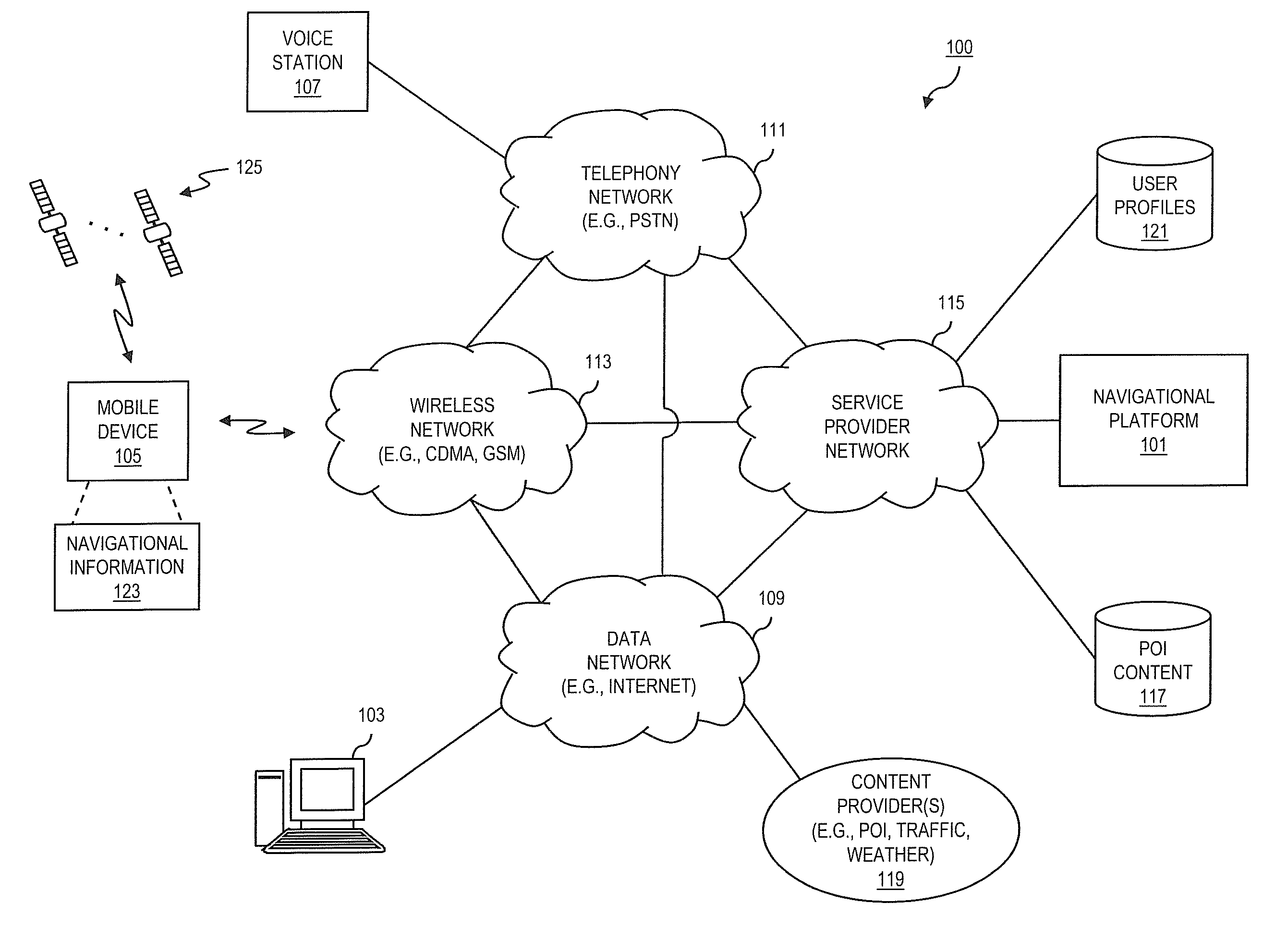
[0013]A preferred apparatus, method, and software for providing managed navigational services are described. In the following description, for the purposes of explanation, numerous specific details are set forth in order to provide a thorough understanding of the preferred embodiments of the invention. It is apparent, however, that the preferred embodiments may be practiced without these specific details or with an equivalent arrangement. In other instances, well-known structures and devices are shown in block diagram form in order to avoid unnecessarily obscuring the preferred embodiments of the invention.

[0014]Although various exemplary embodiments are described with respect to global positioning system (GPS) technology, it is contemplated that various exemplary embodiments are also applicable to other equivalent navigational and location determination technologies.

[0015]FIG. 1 is a diagram of a system capable of providing navigational services, according to an exemplary embodimen...


PUM


Abstract

An approach is provided for a managed navigational service. Real-time positional information corresponding to a user is received over a communication network. An approaching point of interest is determined based on the positional information. The approaching point of interest is correlated with travel information and metadata associated with the approaching point of interest. Information about the approaching point of interest is transmitted over the communication network to the user.

Description

BACKGROUND INFORMATION[0001]The advent of wireless communication systems has served as a catalyst for the ubiquity of mobile computing devices, as well as the introduction of increasingly more complex services, such as navigational services. In conjunction with location-awareness technologies, like global positioning system (GPS) receivers, mobile computing devices now enable consumers to obtain real-time routing information, e.g., turn-by-turn directions, while en route to a predetermined destination. In order to facilitate terrestrial navigation, this routing information is typically presented with a topological depiction of a geographic area surrounding the destination, which may also be appended with various cartographic features, such as buildings, landmarks, roadways, signs, and the like. However, little effort has been devoted to providing more interactivity with the user, or richer navigational services.[0002]Therefore, there is a need for an approach that provides for more ...

Claims


Application Information

Patent Timeline
Patent Type & Authority Applications(United States)
IPC IPC(8): G01C21/30
CPCG01C21/3679H04L67/18H04W4/02H04W4/024H04W4/029H04L67/52
Inventor TRIVEDI, PRAKASH
Owner VERIZON PATENT & LICENSING INC
Learn More