
System and method for drawing stream and road centerline for GIS-based linear map production

a technology of geographic information system and linear map, applied in maps/plans/charts, instruments, teaching apparatus, etc., can solve the problem of reference data being used only in the limit of existing stream or road centerline, and achieve the effect of low accuracy and considerable time, and easy updating of map data

Inactive Publication Date: 2011-06-30
GEUM RIVER WATER CONSERVANCY +1
View PDF2 Cites 23 Cited by
  • Summary
  • Abstract
  • Description
  • Claims
  • Application Information

AI Technical Summary

Benefits of technology

[0011]According to a system and method for drawing a stream and road centerline for GIS-based linear map production of the present invention, it is possible to remarkably improve an existing process of drawing a centerline of a stream and road with low accuracy and considerable time which is consumed in producing and updating a map using the centerline of the stream and road. By generating accurate centerline data for a short period of time, it is possible to produce a small-scale map that closely approximates reality and to easily update map data. Further, the system and method according to the present invention can be variously used in practical fields such as spatial analysis research such as accurate network analysis using accurate linear data of a stream and road and distance calculation, shape change detecting and monitoring research, or other scientific research fields.

Problems solved by technology

That is, since the existing stream or road centerline is not drawn based on a strict criterion, there is a limit in that the existing stream or road centerline is used as reference data of the accurate analysis or use.
In addition, the existing stream or road centerline may cause an unintended result.

Method used


Image

  • System and method for drawing stream and road centerline for GIS-based linear map production
  • System and method for drawing stream and road centerline for GIS-based linear map production
  • System and method for drawing stream and road centerline for GIS-based linear map production

Examples


Embodiment Construction

[0032]Hereinafter, the present invention will be described in detail with reference to the accompanying drawings.

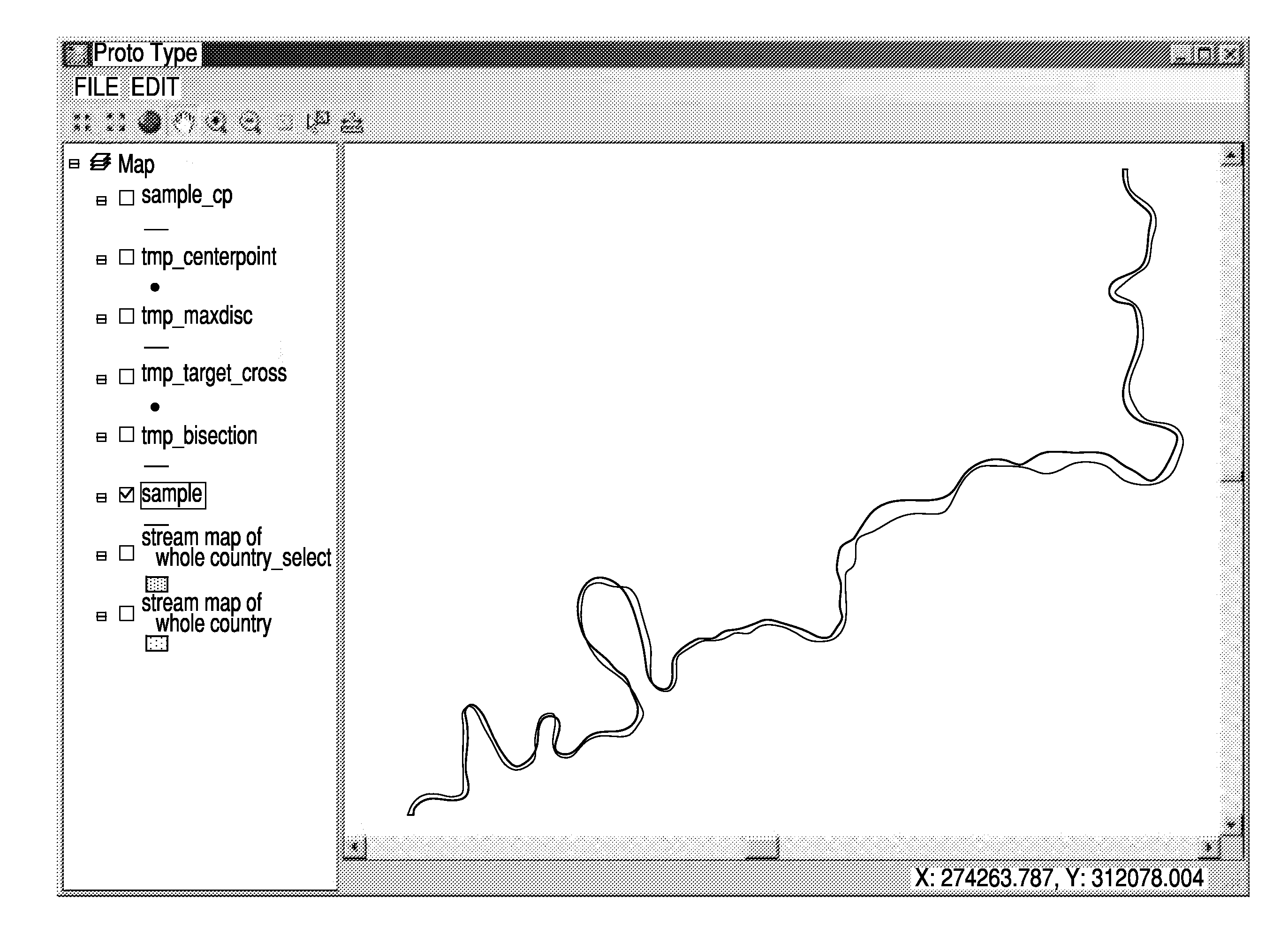
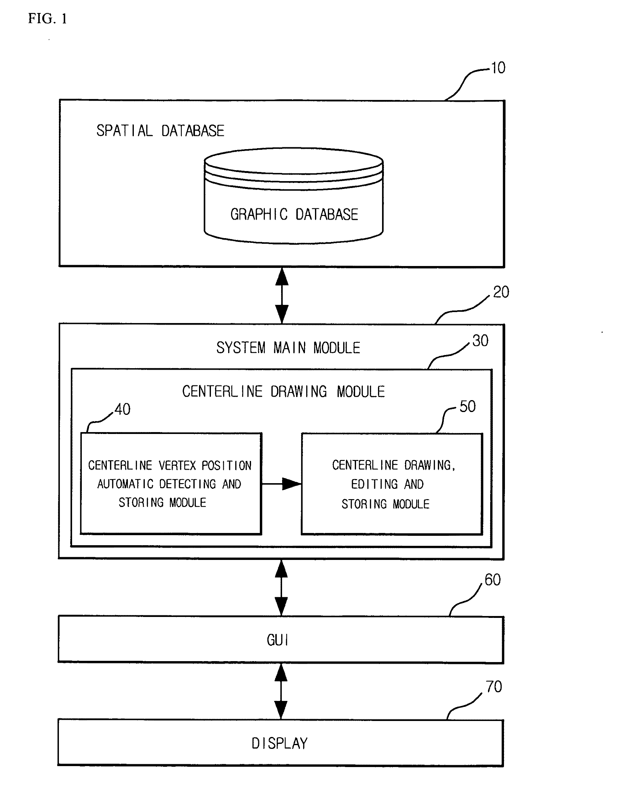
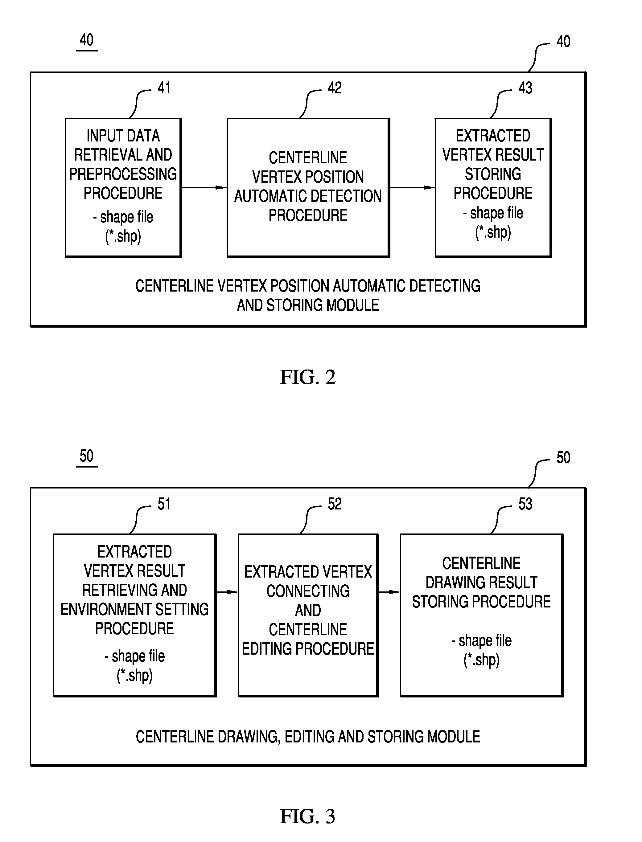
[0033]FIG. 1 is a block diagram showing the configuration of a system for drawing a stream and road centerline for GIS-based linear map production according to an embodiment of the present invention, FIG. 2 is a block diagram showing a process of automatically detecting the positions of vertexes, through which a centerline passes, and storing the detection result, in the system for drawing the stream and road centerline for GIS-based linear map production according to the embodiment of the present invention, FIG. 3 is a block diagram showing a process of connecting the stored vertexes, drawing and editing the centerline, and storing the result, in the system for drawing the stream and road centerline for GIS-based linear map production according to the embodiment of the present invention.

[0034]The system for drawing the stream and road centerline for GIS-based linear map ...


PUM


Abstract

Disclosed herein is a system and method for drawing a stream and road centerline for GIS-based linear map production, which performs a series of processes of automatically detecting accurate positions of points of a centerline using contour line data of a stream map or a road map having a digital map form, which is extracted from a digital map produced through remote sensing or construction of national geographic information systems, and connecting the detected points of the centerline so as to update stream and road centerline data generated by an inaccurate method and algorithm and to enable an accurate centerline to be used in various application fields.

Description

BACKGROUND OF THE INVENTION[0001]1. Field of the Invention[0002]The present invention relates to a system and method for drawing a stream and road centerline for Geographic Information System (GIS)-based linear map production, and, more particularly, to a system and method for drawing a stream and road centerline for GIS-based linear map production, which performs a series of processes of automatically detecting accurate positions of points on a centerline using contour line data of a stream map or a road map having a digital map form, which is extracted from a digital map produced through remote sensing or construction of national geographic information systems, and connecting the detected points of the centerline so as to update stream and road centerline data generated by an inaccurate method and algorithm of the related art and to enable an accurate centerline to be used in various application fields.[0003]2. Description of the Related Art[0004]As known, in a current system used...

Claims


Application Information

Patent Timeline
Patent Type & Authority Applications(United States)
IPC IPC(8): G09G5/00
CPCG09B29/106G09B11/00G09B29/004
Inventor KIM, KYEHYUNCHEON, SEUKLEE, HYUKLEE, CHOLYOUNGPARK, YONGGIL
Owner GEUM RIVER WATER CONSERVANCY
Learn More