Navigation system with geofence validation and method of operation thereof

a technology of navigation system and geofence, which is applied in the field of navigation system, can solve the problems that the solution to these problems has long eluded those skilled in the ar

Inactive Publication Date: 2011-07-21
TELENAV
View PDF16 Cites 109 Cited by
  • Summary
  • Abstract
  • Description
  • Claims
  • Application Information

AI Technical Summary

Benefits of technology

The present invention provides a navigation system including: a control unit for delivering a first message with a target location for a first business for displaying on a device; a location unit, coupled to the control unit, for receiving a current location for monitoring the device; a calculate detection geofence module, coupled to the location unit, for calculating a business detection geofence encompassing the target location of the first busin

Problems solved by technology

The demand for more information and the need to provide user-friendly experience, low latency, and accuracy continue to challenge the providers of navigation systems.
Solutions to th

Method used


Image

  • Navigation system with geofence validation and method of operation thereof
  • Navigation system with geofence validation and method of operation thereof
  • Navigation system with geofence validation and method of operation thereof

Examples


first embodiment

Referring now to FIG. 1, therein is shown a navigation system 100 with geofence validation of encounter type mechanism in the present invention. The navigation system 100 includes a first device 102, such as a client or a server, connected to a second device 106, such as a client or server, with a communication path 104, such as a wireless or wired network.

For example, the navigation system 100 can include positioning systems that determine location using GPS, cell tower triangulation, cell sector identification, WiFi location, or any combination thereof. That navigation system 100 can be any of a variety of location-based systems that can include automobile routing systems, personal navigation devices, marine navigation systems, aviation navigation systems, mapping systems, data logging systems, or any combination thereof.

In a further example, the first device 102 can be of any of a variety of mobile devices, such as a cellular phone, personal digital assistant, a notebook computer...

second embodiment

Referring now to FIG. 8, therein is shown an exemplary block diagram of a navigation system 800 with geofence validation of encounter type mechanism in the present invention. The navigation system 800 can include a first device 802, a communication path 804, and a second device 806.

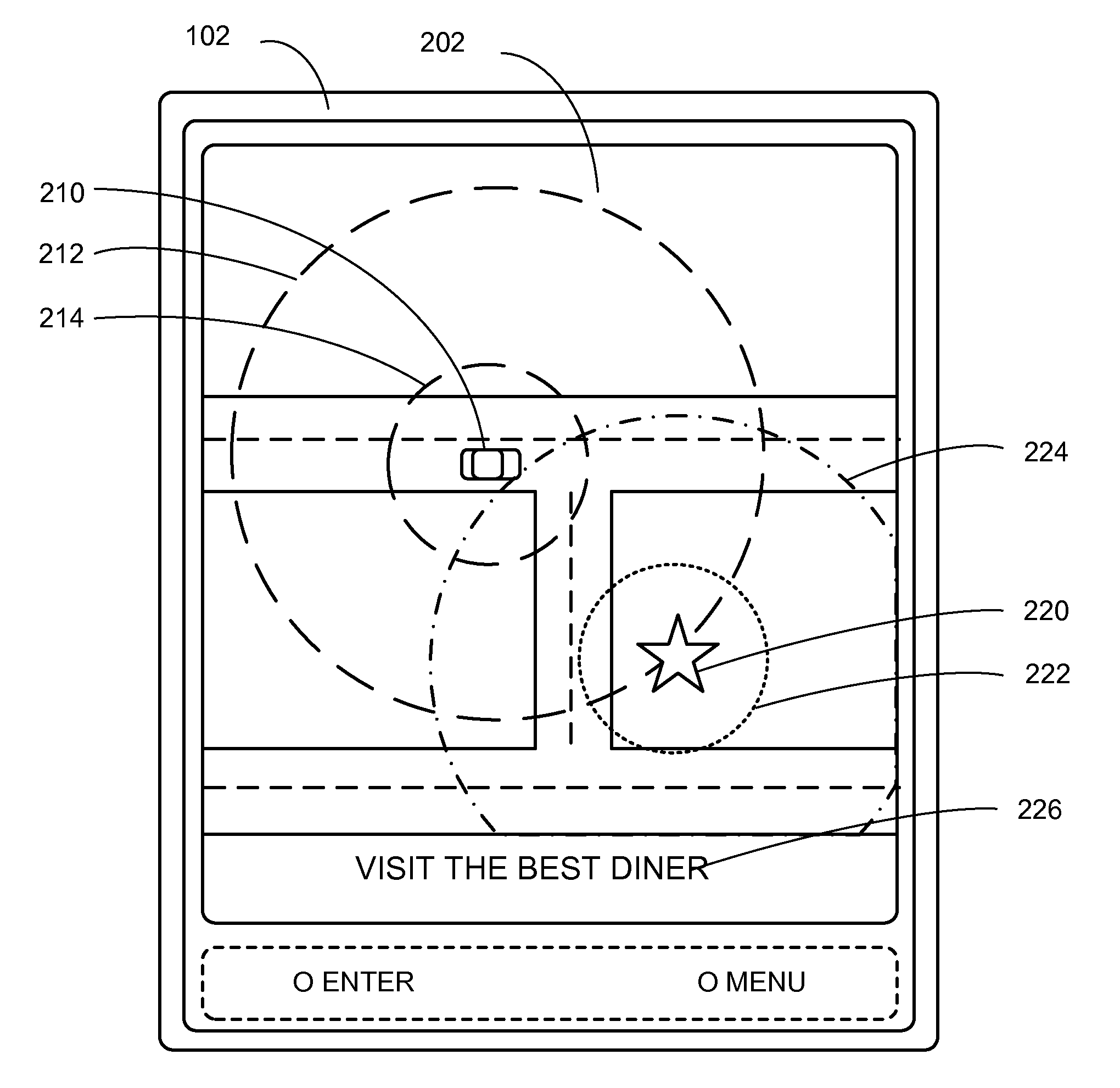
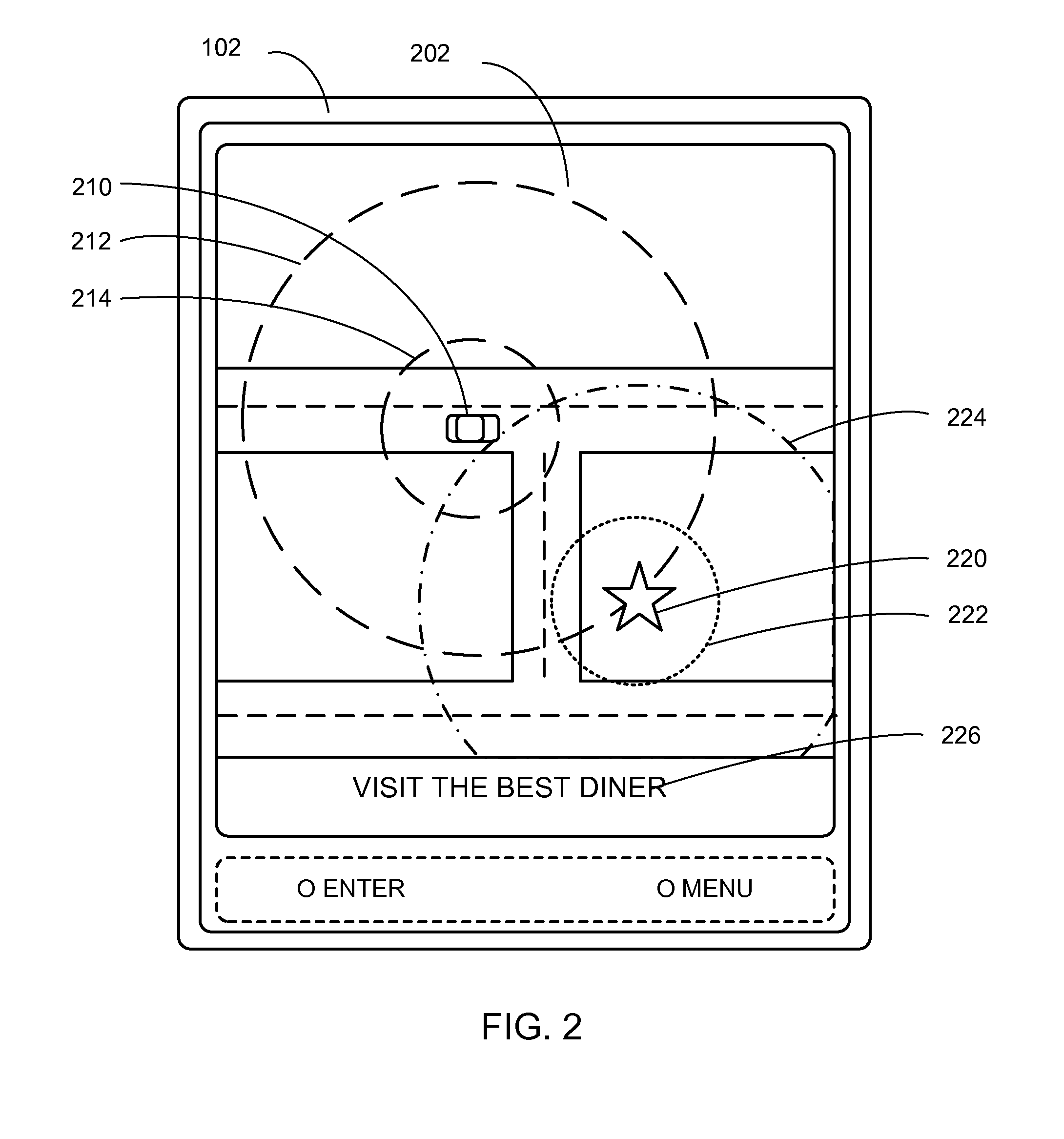
The first device 802 can communicate with the second device 806 over the communication path 804. For example, the first device 802, the communication path 804, and the second device 806 can be the first device 102 of FIG. 1, the communication path 104 of FIG. 1, and the second device 106 of FIG. 1, respectively. The screen shot shown on the display interface 202 described in FIG. 2 can represent the screen shot for the navigation system 800.

The first device 802 can send information in a first device transmission 808 over the communication path 804 to the second device 806. The second device 806 can send information in a second device transmission 810 over the communication path 804 to the first device 802...

third embodiment

Referring now to FIG. 9, therein is shown a navigation system 900 with geofence validation of encounter type mechanism in the present invention. The navigation system 900 can enable the navigation to the first business 220 and operate the display interface 202 of FIG. 2 by presenting a navigation routing information 940 of the first business 220.

In the navigation system 900, as an example, each module is indicated by a number and successively higher module numbers follow one another. Control flow can pass from one module to the next higher numbered module unless explicitly otherwise indicated.

The navigation system 900 can be operated in several different ways. For example, the navigation system 900 can be included in and operated by running the software 712 of FIG. 7. In another example, the navigation system 900 can be partitioned between and operated by running the first software 826 of FIG. 8, the second software 842 of FIG. 8, or a combination thereof.

The navigation system 900 c...


PUM


Abstract

A method of operation of a navigation system includes: delivering a first message with a target location for a first business for displaying on a device; receiving a current location for locating the device; calculating a business detection geofence encompassing the target location for detecting the location of the device in the target area of the business detection geofence; detecting an entry to the business detection geofence for detecting the current location of the device being at or within the business detection geofence; detecting an encounter between the device and the business detection geofence for the entry into the business detection geofence in a response to the first message; and determining a uniqueness of the encounter for indicating the encounter between the device and the business detection geofence.

Description

TECHNICAL FIELDThe present invention relates generally to a navigation system, and more particularly to a navigation system for geofence validation of an encounter type.BACKGROUND ARTModern portable consumer and industrial electronics provide increasing levels of functionality to support modern life including location-based information services. This is especially true for client devices such as navigation systems, cellular phones, portable digital assistants, and multifunction devices.As users adopt mobile location-based service devices, new and old usages begin to take advantage of this new device space. There are many solutions to take advantage of this new device opportunity. One existing approach is to use location information to provide navigation services, such as a global positioning service (GPS) navigation system for a mobile device.In response to consumer demand, navigation systems are providing ever-increasing amounts of information requiring these systems to improve usa...

Claims


Application Information

Patent Timeline
IPC IPC(8): G01C21/00G06Q99/00
CPCG01C21/362H04W4/021H04W4/02G06Q30/02H04W4/024
Inventor SHERIDAN, JOHN
Owner TELENAV
Why Eureka
Try Eureka