Weather-sensitive route mapping

a route mapping and weather-sensitive technology, applied in the field of wireless communication, can solve problems such as unforeseen events

Inactive Publication Date: 2011-12-15
TELECOMM SYST INC
View PDF6 Cites 39 Cited by
  • Summary
  • Abstract
  • Description
  • Claims
  • Application Information

AI Technical Summary

Problems solved by technology

However, the present inventor has appreciated that unforeseen events may occur along the future route.

Method used


Image

  • Weather-sensitive route mapping
  • Weather-sensitive route mapping
  • Weather-sensitive route mapping

Examples


Embodiment Construction

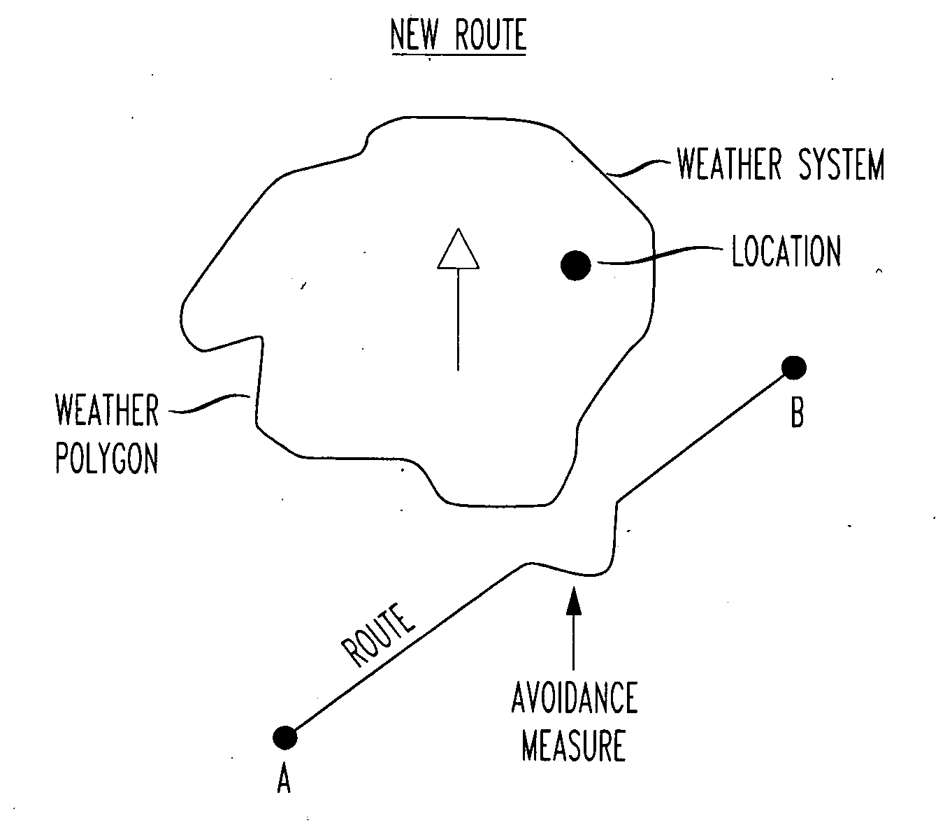
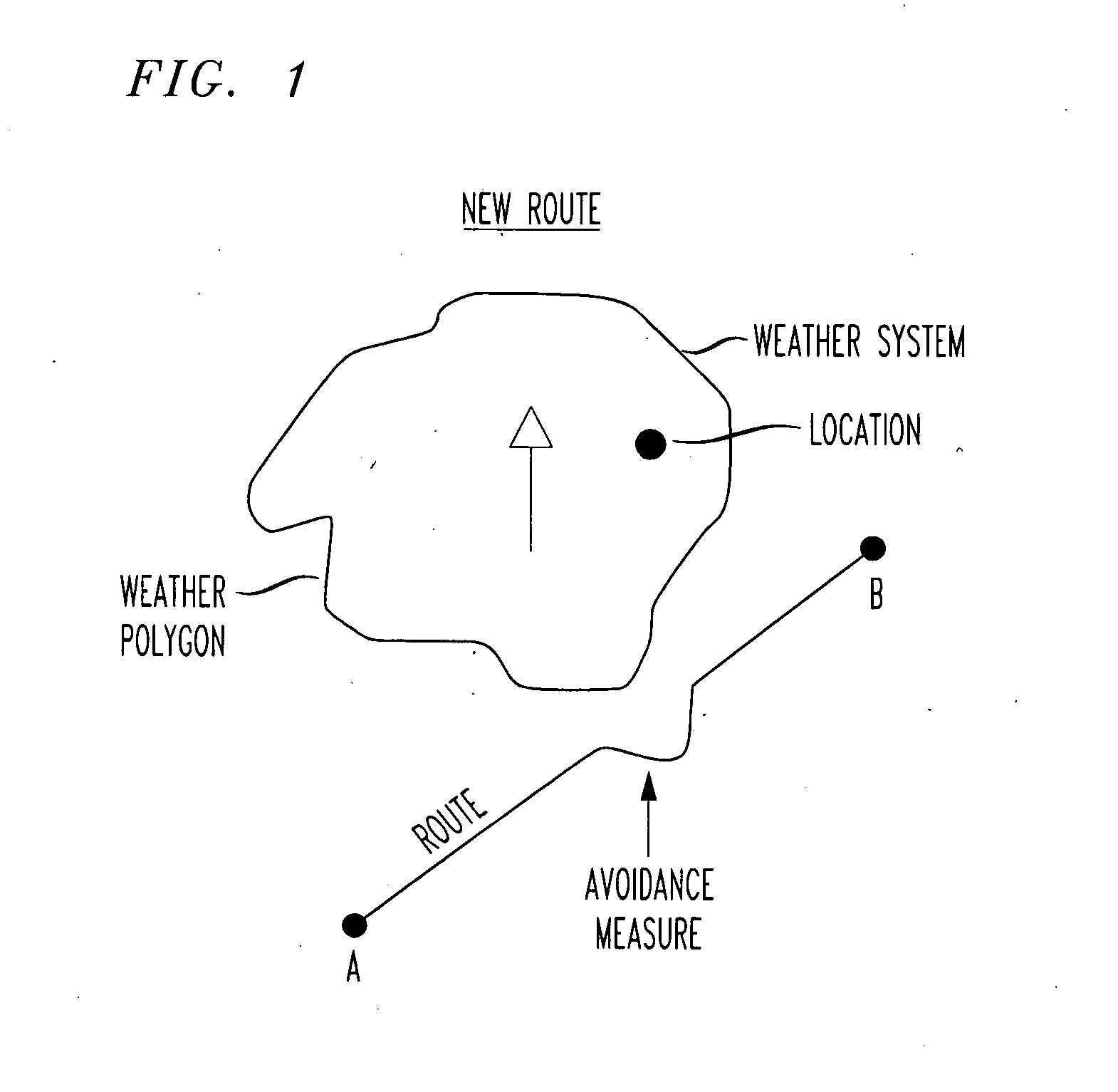
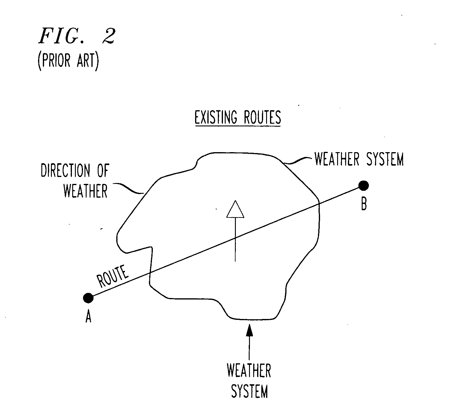
[0012]The present inventor has appreciated that future weather affects a navigated route to be traveled, much like a traffic accident or the like, even though the weather has not yet crossed onto a portion of the path to be traveled. Using conventional techniques, a traveler must rely on a weather forecast before taking off on a trip to decide if, when and what roads to travel. When making such a decision, the traveler must become somewhat clairvoyant, particularly on longer trips, as weather patterns move over time and may or may not affect a point in the trip when the traveler reaches that point.

[0013]At best, conventional navigation systems require a user to select a desired fixed distance ahead on the route to have re-routed as a detour route. However, such conventional systems require the traveler to decide on their own how to detour around a weather system, e.g., a motorcyclist coming upon a sudden rain storm), or a traveler alerted to possible thunderstorms in the area for th...


PUM


Abstract

A wireless phone navigation system that obtains and uses weather system data to alert and re-route a user around inclement weather located at a point on the user's navigated route, as predicted to be at a time in the future that the user would otherwise be expected to traverse that part of the navigated route. A weather polygon is drawn around a perimeter of a weather system obtained from current weather data. The weather polygon (or other shape) may be drawn based on configurable weather items to be avoided, e.g., rain, ice conditions, snow on ground, etc. The re-routing may be based on a prediction of a future position of a weather system with respect to where on a navigated route a user will be at that future time.

Description

[0001]The present application claims priority from U.S. Provisional No. 61 / 344,222 entitled “WEATHER-SENSITIVE ROUTE MAPPING SYSTEM”, filed Jun. 14, 2010, the entirety of which is explicitly incorporated herein by reference.BACKGROUND OF THE INVENTION[0002]1. Field of the Invention[0003]This invention relates generally to wireless communication. In particular, it relates to GPS-based navigation services that provide turn-by-turn directions on a wireless device.[0004]2. Background of Related Art[0005]Turn-by-turn navigation on wireless phone devices such as wireless smartphones is known. However, the present inventor has appreciated that unforeseen events may occur along the future route. For instance, wireless phone navigation used by travelers such as bicyclists, motorcyclists, etc., may unexpectedly direct them into a travel route through a location of an unknown current or future traffic accident.[0006]FIG. 2 shows a conventionally-navigated route from location A to location B, w...

Claims


Application Information

Patent Timeline
Patent Type & Authority Applications(United States)
IPC IPC(8): G01C21/00
CPCG01C21/3492
Inventor KIEFF, RYAN
Owner TELECOMM SYST INC
Why Eureka
Try Eureka