Mobile navigation system

a mobile navigation and navigation system technology, applied in traffic control systems, navigation instruments, instruments, etc., can solve the problem of limited role of the client system, and achieve the effect of minimal detail necessary for the mapping database of the client installed

Inactive Publication Date: 2012-10-04
INFOGATION CORP
View PDF9 Cites 47 Cited by
  • Summary
  • Abstract
  • Description
  • Claims
  • Application Information

AI Technical Summary

Benefits of technology

[0016]The present invention alleviates many of the failings of the prior art. One advantage of the present invention is that it alleviates the need to have specific pre-defined turn-by-turn mapping databases installed on the client. The present invention can be used with any mapping database installed on the client navigation system. In addition, the level of detail necessary for the client-installed mapping database is minimal.
[0017]Another advantage of the present invention is that the client navigation system can be made much less complex than those used in current systems. A feature of the present invention is that the server performs routing generation on behalf of the client. The routing generation takes all real-time variables into account, as well as user preferences and the like. Accordingly, the present invention alleviates the need to install sophisticated and expensive routing algorithms and / or complex hardware components on the client that are used to perform local routing calculations. In many cases, the role of the client system can be limited to displaying routes generated by the server.
[0018]Another advantage of the present invention is that it does not require software changes on the client navigation systems whenever the server provides new and / or modified features. All enhancements to the services provided by the server are independent from the software installed on the client.

Problems solved by technology

In many cases, the role of the client system can be limited to displaying routes generated by the server.

Method used


Image

  • Mobile navigation system
  • Mobile navigation system
  • Mobile navigation system

Examples


Embodiment Construction

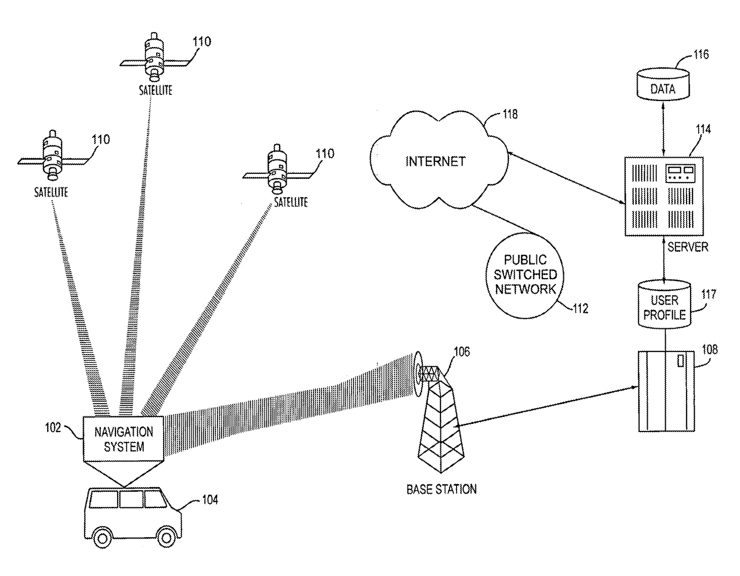
[0044]FIG. 1 depicts an operational environment according to an embodiment of the present invention. A navigational system 102 is installed in a mobile unit such as an automobile 104. In one embodiment, the navigation system 102 receives data from Global Positioning System (GPS) satellites 110 for tracking purposes. A minimum number of three satellites is needed to obtain accurate readings. As described below, the connection to the GPS satellites 110 is an optional component of the navigation system 102 according to the present invention.

[0045]The navigation system 102 has the capability for wireless communications. In this example, one use of the wireless communication feature is to connect the navigation system 102 with a computer network, such as the Internet 118. The wireless communication feature of the present invention is also used for providing standard telephony functions.

[0046]In one example, cellular technology is used to implement the wireless communication feature of th...


PUM


Abstract

A client navigation system establishes a wireless connection to a navigation server on a computer network. The client requests a route by uploading start and stop specifications. The server calculates an optimal route based on real-time data available on the network. A generic natural language description is used to specify the optimal route downloaded to the client. The natural language description is independent from the local mapping database software on the client and includes a plain text description for each link using pre-defined generic terms. The client interprets the route, interfaces with the local mapping database and reconstructs the optimal route using a mapping reconstruction algorithm. The route is displayed on the client navigation system using whatever mapping database is present.

Description

CROSS-REFERENCE TO RELATED APPLICATION[0001]This is a continuation of co-pending U.S. application Ser. No. 09 / 935,463, entitled “Method and apparatus for determining a time zone in GPS devices”, filed Aug. 22, 2001 and now U.S. Pat. No. 8,200,426, which is a continuation of co-pending U.S. application Ser. No. 09 / 227,331, entitled “Mobile navigation system”, filed Jan. 6, 1999 and now U.S. Pat. No. 6,292,743.BACKGROUND OF THE INVENTION[0002]1. Field of the Invention[0003]The present invention relates generally to mobile navigation system and apparatus, and more particularly to a distributed navigation system having a wireless connection to a server for calculating optimal routes using real-time data.[0004]2. Related Art[0005]In recent years, navigation systems, in which automobiles are equipped with a navigational computer that includes a display screen, an input means such as a keypad or a remote control, and a storage means such as a CD, have become popular. Geographical map and r...

Claims


Application Information

Patent Timeline
Patent Type & Authority Applications(United States)
IPC IPC(8): G01C21/34G01C21/36G01C21/26H04W4/02G08G1/0968H04W4/024
CPCG01C21/26G08G1/096811G08G1/096883G08G1/096861G08G1/096838H04W4/02G01C21/362G01C21/3415G01C21/3626G01C21/3617G01C21/3484H04W4/024G01C21/3453G01C21/3476G01C21/3492G01C21/3608G01C21/3667G01S19/42G01C21/343G08G1/096827
Inventor PU, QING KENTLI, HUI HENRY
Owner INFOGATION CORP
Why Eureka
Try Eureka