Rendering and Navigating Photographic Panoramas with Depth Information in a Geographic Information System

a geographic information system and panorama technology, applied in the field of geographic information systems, can solve the problems of inability to incorporate gis data for the purpose of transitioning from one photograph to the next, lack of three-dimensional information associated,

Active Publication Date: 2012-11-29
GOOGLE LLC
View PDF3 Cites 111 Cited by
  • Summary
  • Abstract
  • Description
  • Claims
  • Application Information

AI Technical Summary

Problems solved by technology

This is particularly due to a lack of three-dimensional information associated with the photographs.
Further, GIS data cannot be incorporated for purposes of transitioning from one photograph to the next as the substantially spherical model does not correspond to the actual geometry of the Earth.

Method used


Image

  • Rendering and Navigating Photographic Panoramas with Depth Information in a Geographic Information System
  • Rendering and Navigating Photographic Panoramas with Depth Information in a Geographic Information System
  • Rendering and Navigating Photographic Panoramas with Depth Information in a Geographic Information System

Examples


example gui

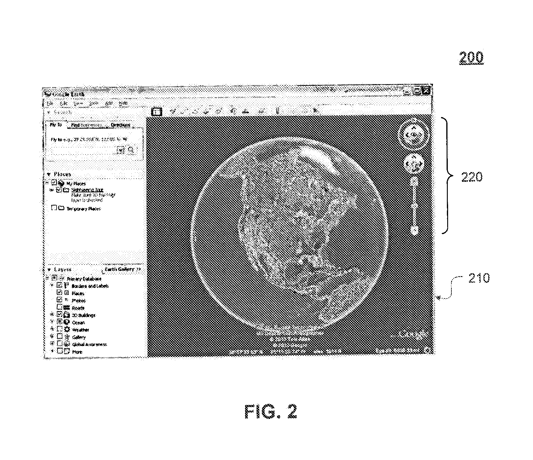
[0034]FIG. 2 shows an exemplary GUI 200 of a geospatial browser (e.g., browser 120 of FIG. 1, described above), according to an embodiment. In the example shown in FIG. 2, geographic data is shown in a display area 210. In an embodiment, display area 210 uses a viewport embedded within the geospatial browser to present the geographic data from the perspective of a virtual camera. In an embodiment, the perspective is defined by a view frustum such as, for example, a truncated three-dimensional pyramid. Geographic data within the view frustum can be displayed at varying levels of detail depending on its distance from the virtual camera. Example geographic data displayed in display area 210 includes images of the Earth. It is noted that images of other planets (e.g., Mars) and / or celestial bodies (e.g., the Moon) may also be displayed in display area 210. For example, these images can be rendered onto a geometry representing the Earth's terrain creating a three dimensional model of the...


PUM


Abstract

The capability to render and navigate three-dimensional panoramic images in a virtual three-dimensional environment so as to create an immersive three-dimensional experience is provided. Such a capability can present a three-dimensional photographic experience of the real world that is seamlessly integrated with the virtual three-dimensional environment. Depth values associated with the panoramic images may be used to create three-dimensional geometry, which can be rendered as part of the virtual three-dimensional environment. Further, such a capability can enable a user to roam freely through the environment while providing a more natural free-form exploration of the environment than existing systems.

Description

CROSS REFERENCE TO RELATED APPLICATIONS[0001]This patent application claims the benefit of U.S. Provisional Patent Application No. 61 / 417,111, (Attorney Docket No. 2525.4720000), filed Nov. 24, 2010, entitled “Rendering and Navigating Photographic Panoramas with Depth Information in a Geographic Information System” which is incorporated herein by reference in its entirety.BACKGROUND[0002]1. Field[0003]Embodiments relate generally to geographic information systems.[0004]2. Background[0005]A geographic information system (GIS) is a system for archiving, retrieving, displaying or manipulating data indexed according to the data elements' geographic coordinates. The data elements may be a variety of data types such as, for example, satellite imagery, maps, models of buildings and terrain, and other geographic features. Further, data elements may include geo-located photographs of real world scenes corresponding to various geographic locations. For example, the geo-located photographs may...

Claims


Application Information

Patent Timeline
Patent Type & Authority Applications(United States)
IPC IPC(8): G06T17/20
CPCG06T19/00G06T17/20G06T17/00
Inventor COOMBE, GREGBARCAY, DANIELVARADHAN, GOKULBAILLY, FRANCOIS
Owner GOOGLE LLC
Why Eureka
Try Eureka