System and method for providing tile-map using electronic navigation chart

a technology of electronic navigation chart and tile-map, which is applied in the direction of navigation instruments, static indicating devices, instruments, etc., can solve the problems of uncorrectly expressed objects necessary to be expressed in a high zoom level, and achieve the effect of reducing the communication load of a spatial information service and increasing the efficiency of disc spa

Inactive Publication Date: 2014-09-11
ELECTRONICS & TELECOMM RES INST
View PDF5 Cites 27 Cited by
  • Summary
  • Abstract
  • Description
  • Claims
  • Application Information

AI Technical Summary

Benefits of technology

[0025]According to embodiments of the present invention, disc space efficiency may be increased with respect to a region having low frequency of data such as an object or a region corresponding to a tile map including only a single color. In addition, a communication load of a spatial information service may be reduced.
[0026]Additionally, according to embodiments the present invention, various analyses may be performed based on dynamic sensing information and static sensing information, and the analysis result may be reflected in tile presentation.
[0027]Additionally, tiling is performed in consideration of not only image-based tile map data and vector-based tile m...

Problems solved by technology

However, since a most part of the tile maps include an area in only a single col...

Method used


Image

  • System and method for providing tile-map using electronic navigation chart
  • System and method for providing tile-map using electronic navigation chart
  • System and method for providing tile-map using electronic navigation chart

Examples


Embodiment Construction

[0036]Reference will now be made in detail to exemplary embodiments of the present invention, examples of which are illustrated in the accompanying drawings, wherein like reference numerals refer to the like elements throughout.

[0037]In the description of the present invention, if detailed descriptions of related disclosed art or configuration are determined to unnecessarily make the subject matter of the present invention obscure, they will be omitted. Terms to be used below are defined based on their functions in the present invention and may vary according to users, user's intentions, or practices. Therefore, the definitions of the terms should be determined based on the entire specification.

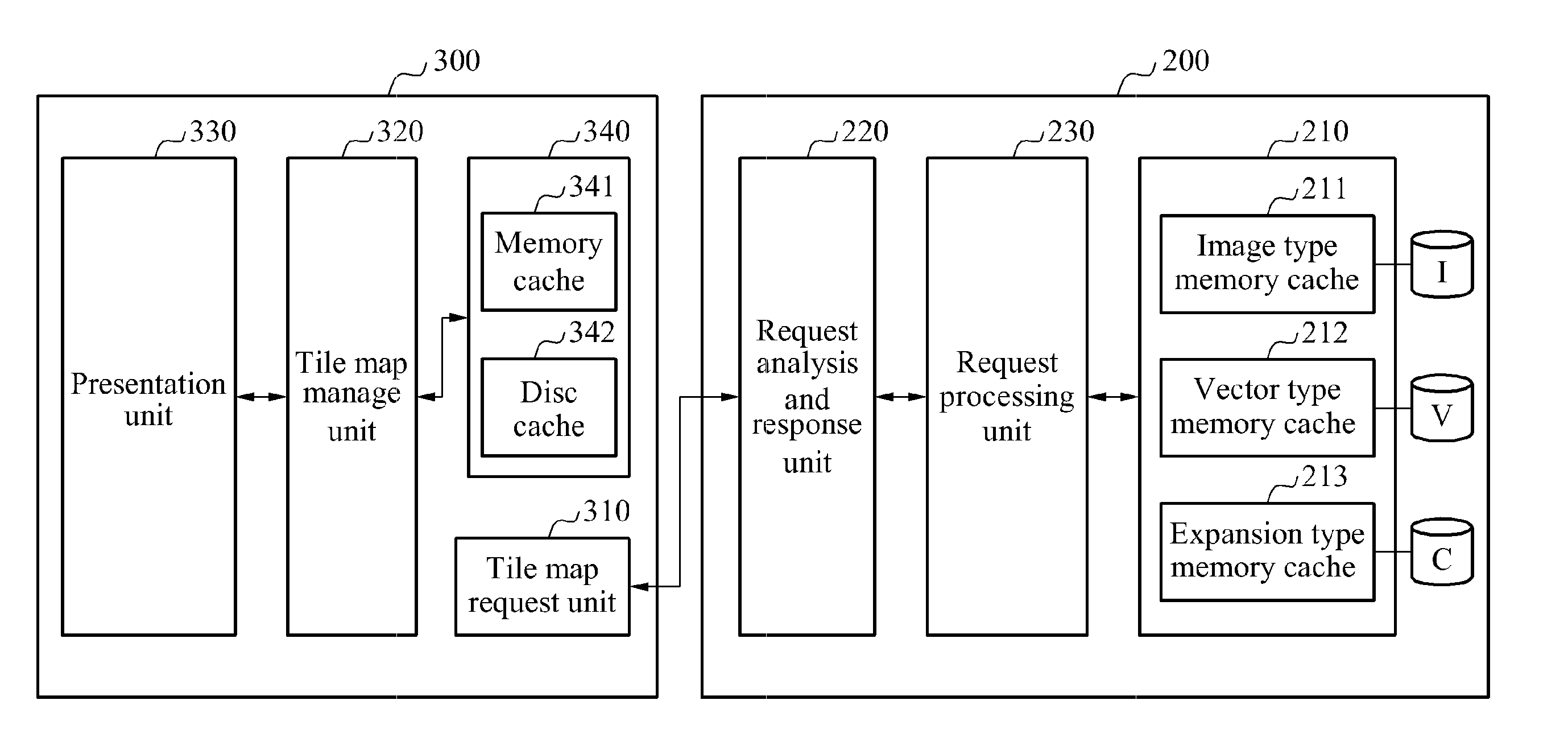
[0038]FIG. 1 is a block diagram illustrating a configuration of a tile map generation apparatus 100 using an electronic navigation chart, according to an embodiment of the present invention.

[0039]Referring to FIG. 1, the tile map generation apparatus 100 may include a layer set unit 110, a ti...


PUM


Abstract

A system and method are provided, the system and method for providing a tile map related to a region having low data frequency or a region having same color property, by providing the tile map using not only national territorial information on land but also marine spatial information and dynamic sensing information.

Description

CROSS-REFERENCE TO RELATED APPLICATION[0001]This application claims the benefit of Korean Patent Application No. 10-2013-0025122, filed on Mar. 8, 2013, in the Korean Intellectual Property Office, the disclosure of which is incorporated herein by reference.BACKGROUND[0002]1. Field of the Invention[0003]The present invention relates to a system and method for providing an image of a web or local storage system, or tile map data in a vector form, and more particularly, to a system and method for providing a tile map related to a region having low data frequency or a region having same color attribute, by providing the tile map using not only national territorial information on land but also marine spatial information and dynamic sensing information.[0004]2. Description of the Related Art[0005]A spatial information service technology provides users with spatial information and various relevant attribute information. Not only overseas enterprises but also domestic enterprises actively p...

Claims


Application Information

Patent Timeline
IPC IPC(8): G06T11/20
CPCG06T11/20G09B29/005G09B29/007G01C21/3881G06T1/00G06F17/00G06T17/05
Inventor JANG, IN SUNGLEE, CHUNG HOKIM, MIN SOO
Owner ELECTRONICS & TELECOMM RES INST
Why Eureka
Try Eureka