
System, method, and apparatus for minimizing power consumption in a portable device capable of receiving satellite navigational system signals

a satellite navigation and portable device technology, applied in the field of minimizing power consumption in portable devices, can solve the problems of one or more batteries not lasting for a long time, one or more batteries being unable to track, and the portability/mobile device tracking is an even bigger drain on battery resources, so as to reduce power consumption, minimize power consumption, and reduce power

Active Publication Date: 2015-08-20
SAMSUNG ELECTRONICS CO LTD
View PDF1 Cites 12 Cited by
  • Summary
  • Abstract
  • Description
  • Claims
  • Application Information

AI Technical Summary

Benefits of technology

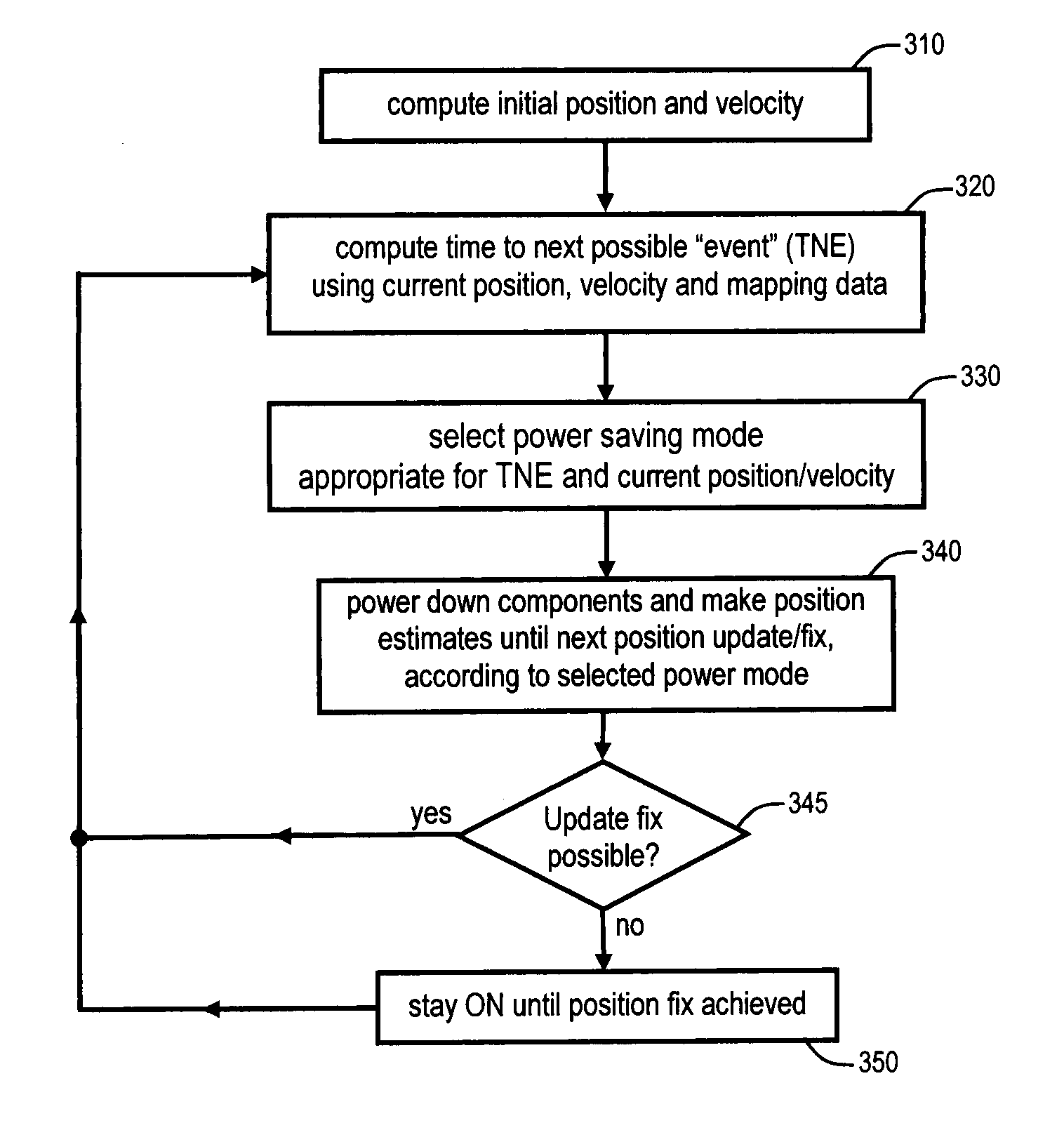
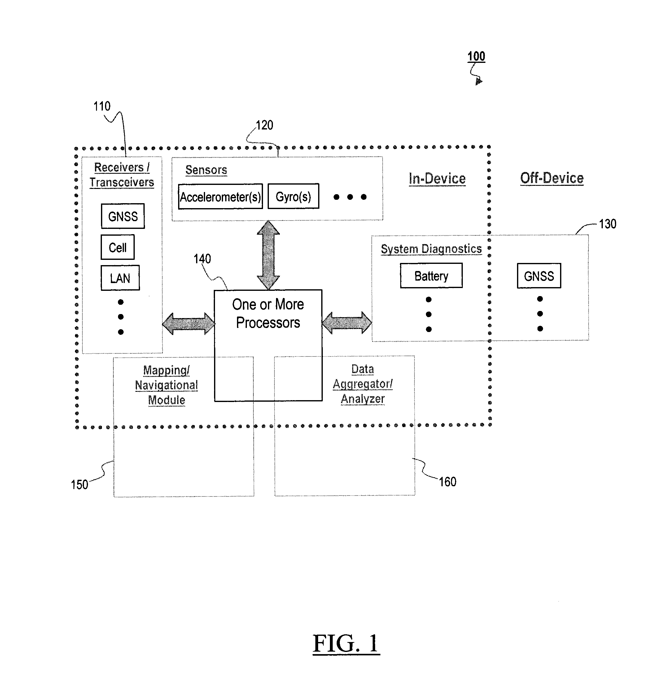
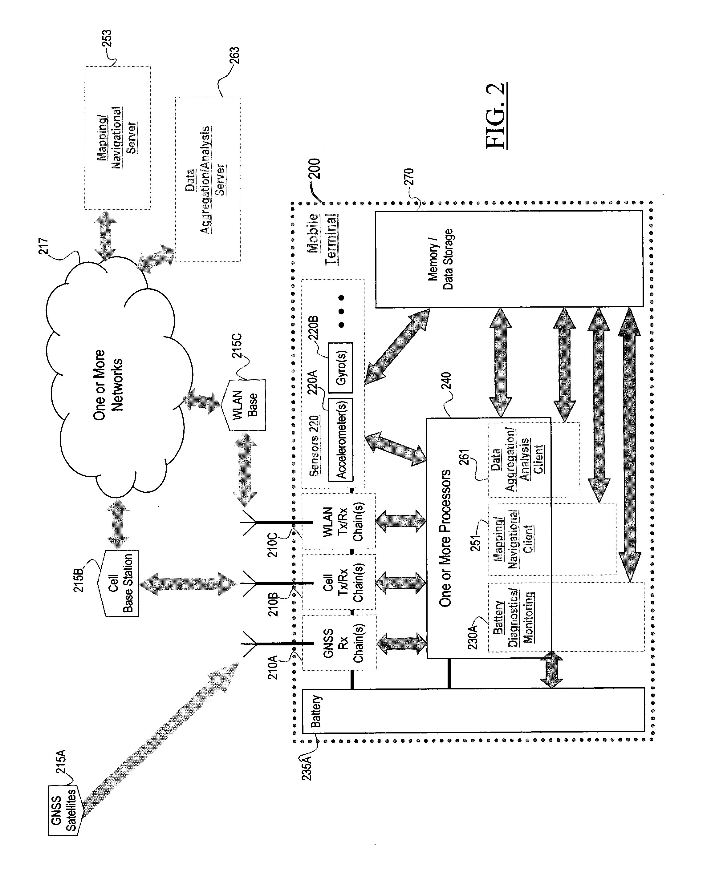
The present invention provides a portable device that can receive GNSS signals and adapt to expected resource requirements during travel. It minimizes power consumption during route navigation by using adaptive systems and methods which store and analyze data concerning system resource conditions and usage. The device can also aggregate data from multiple portable devices to further optimize resource usage. In addition, the invention provides a mapping / navigational data used in the adaptive systems for minimizing power consumption by GNSS signal reception, processing, and positional computing. It also allows the device to select the most appropriate power saving mode based on the current location and route information, and reduces the frequency of positional updates / fixes by estimating the current position in between updates.

Problems solved by technology

The tracking of a portable / mobile device with GNSS capabilities is an even bigger drain on battery resources.
When the GNSS capability is being used for continuous updating of positional information, such as when navigating a route in a moving vehicle or while walking in unfamiliar terrain, it is a particularly large drain on the one or more batteries, potentially resulting in the one or more batteries not lasting until the end of the route being navigated.

Method used


Image

  • System, method, and apparatus for minimizing power consumption in a portable device capable of receiving satellite navigational system signals
  • System, method, and apparatus for minimizing power consumption in a portable device capable of receiving satellite navigational system signals
  • System, method, and apparatus for minimizing power consumption in a portable device capable of receiving satellite navigational system signals

Examples


Embodiment Construction

[0021]Various embodiments of the present invention will be described in detail below with reference to the accompanying drawings, wherein like reference numerals are generally used to refer to like elements throughout. In the following description, for purposes of explanation, numerous specific details are set forth in order to provide a thorough understanding of the claimed subject matter. It may be evident, however, that the claimed subject matter may be practiced without these specific details. In other instances, structures and devices are illustrated in block diagram form in order to facilitate describing the claimed subject matter.

[0022]In general, the present invention relates to improvements in power consumption / saving for any portable device having a mapping capability and a GNSS receiver / processing capability, where various embodiments of the present invention may have one or more of the following:[0023](1) the use of specific features from map data of regions of traversal...


PUM


Abstract

Methods, systems, and portable devices which reduce the power used by a portable device to receive / process satellite navigational system signals and / or to compute the portable device's position using satellite navigational system signals are described. One portable device retrieves power usage information corresponding to its current location, where the power usage information is based on aggregate data from portable devices which have traversed and / or are traversing the current location. The portable device then selects a power saving mode from a plurality of power saving modes based on the retrieved power usage information, where each power saving mode reduces power usage in one or more of receiving and / or processing satellite navigational system signals, and / or computing the portable device's position using the satellite navigational system signals.

Description

PRIORITY[0001]This application is a continuation of, and claims priority under 35 U.S.C. §120 to, U.S. patent application Ser. No. 14 / 048,657, which issued as U.S. Pat. No. 8,990,009 on Mar. 24, 2015, which claims priority under 35 U.S.C. §119(e) to U.S. Prov. Pat. App. Ser. No. 61 / 857,928 filed on Jul. 24, 2013, the entire disclosures of each of which are incorporated herein by reference.BACKGROUND OF THE INVENTION[0002]1. Field of the Invention[0003]The present invention relates generally to reducing power consumption in a portable device capable of receiving Global Navigation Satellite System (GNSS) signals, and more particularly, to minimizing battery usage in a portable device having a GNSS receiver being used for navigation.[0004]2. Description of the Related Art[0005]Satellite navigational systems provide positional and timing information to earth-bound receivers. Each system has its own constellation of satellites orbiting the Earth, and, in order to calculate its position, ...

Claims


Application Information

Patent Timeline
Patent Type & Authority Applications(United States)
IPC IPC(8): G01S19/34
CPCG01S19/34G01C21/26
Inventor LENNEN, GARYMILOTA, ANDY
Owner SAMSUNG ELECTRONICS CO LTD
Learn More