Method and apparatus for warehouse cycle counting using a drone
a drone and cycle counting technology, applied in the field of cycle counting inventory, can solve the problems of injury from moving inventory, the risk of personnel injury due to the operation of lifts and lift trucks, so as to reduce the need for unnecessary movement of inventory, reduce the risk of injury, and reduce the effect of cycle count times and labor costs
- Summary
- Abstract
- Description
- Claims
- Application Information
AI Technical Summary
Benefits of technology
Problems solved by technology
Method used
Image
Examples
first embodiment
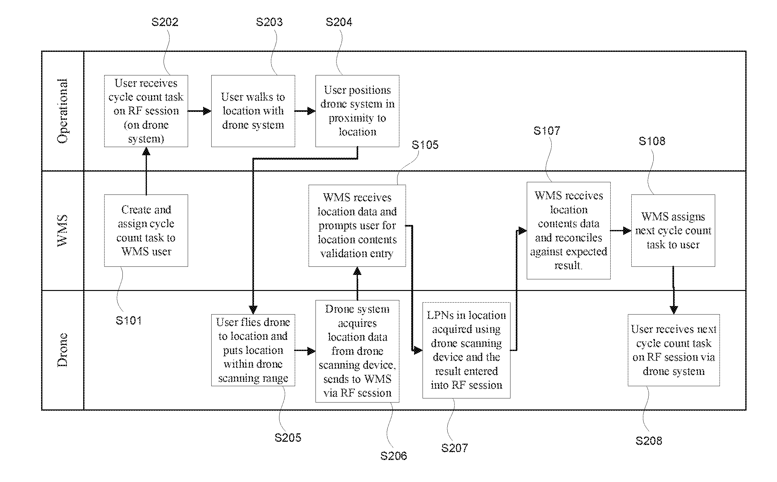
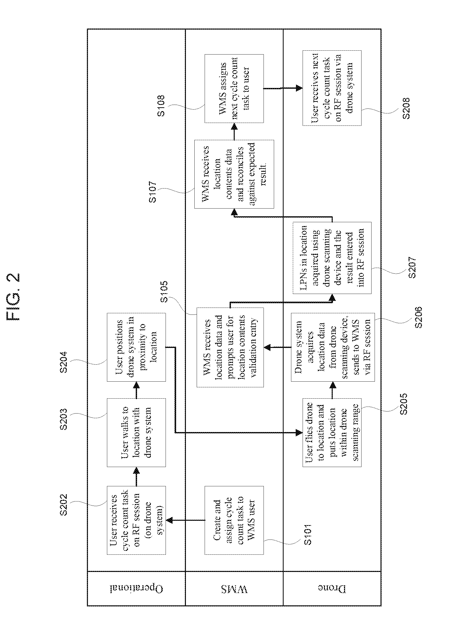
[0092]FIG. 2 is the method of warehouse cycle counting using a drone. In step S101 the WMS creates and assigns a cycle count task to a WMS user. In step S202 the user receives the cycle count task on RF session on drone system; the task will display the location in the warehouse to be cycle counted. In step S203 the user walks to the cycle count location with the drone system. In step S204 the user positions drone system in proximity to location. In step S205 the user flies drone to the location identifier and puts the location identifier within drone scanning range. In step S206 the drone system acquires location data from drone scanning device and then sends the location data to WMS via RF session. In step S105 the WMS receives location data and prompts the user for the location contents validation entry. In step S207 the LPNs in location are acquired using the drone scanning device and the resulting data is entered into RF session. In step S107 the WMS receives location contents ...
second embodiment
[0094]FIG. 4 is the method of warehouse cycle counting using a drone. In step S101 the WMS creates and assigns a cycle count task to the WMS user. In step S202 the user receives the cycle count task on the RF session on the drone system; the task will display the location in the warehouse to be cycle counted. In step S203 the user walks to the location with the drone system, and in step S204 the user positions the drone system in proximity to the location. In step S205 the user flies the drone to location identifier and puts location identifier within drone scanning range. In S206 the drone system acquires the location data from the drone scanning device and sends the data to the WMS via the RF session. In step S105 the WMS receives the location data and prompts the user for location contents validation entry, where in step S209 the LPNs in the location are acquired using drone scanning device and the result entered into RF session. In step S110 the WMS receives the scanned LPN data...
PUM
 Abstract
Description
Claims
Application Information
 - R&D
- Intellectual Property
- Life Sciences
- Materials
- Tech Scout
- Unparalleled Data Quality
- Higher Quality Content
- 60% Fewer Hallucinations
Browse by: Latest US Patents, China's latest patents, Technical Efficacy Thesaurus, Application Domain, Technology Topic, Popular Technical Reports.
© 2025 PatSnap. All rights reserved.Legal|Privacy policy|Modern Slavery Act Transparency Statement|Sitemap|About US| Contact US: help@patsnap.com


