Determining the geographical location from which an emergency call originates in a packet-based communications network

geographical location technology, applied in the field of determining the geographical location from which an emergency call originates in a packet-based communications network, can solve the problems of affecting reliability, unable to use static database entries, and cost in transferring calls, so as to reduce costs

Active Publication Date: 2007-02-13
AVAYA INC
View PDF10 Cites 293 Cited by
  • Summary
  • Abstract
  • Description
  • Claims
  • Application Information

AI Technical Summary

Benefits of technology

[0030]This provides the advantage that an emergency call can be routed using the routing key to an appropriate emergency services network node. This is achieved in a packet-based network without the need to access information from the emergency services network. Thus an existing emergency services network can be used without the need for modification.
[0039]Preferably a location information server is used to provide the geographical location information. This provides the advantage that the location gateway server need not be concerned with the particular methods used to determine the geographical location information.
[0040]Also, the routing key is determined and delivered dynamically within the life of the emergency call. This is achieved by using the location information server to provide the geographical location information as and when needed. This reduces and need for static information to be retained in the network including an emergency services network. In addition, it is possible to deal with nomadic entities and mobile entities whose geographical location changes over time.
[0041]In a preferred embodiment the location gateway server interfaces to the emergency services network using a known interface protocol. This enables the present invention to be used with existing emergency services equipment that already operates the specified interface protocol. This reduces costs and the need for modification of network equipment.

Problems solved by technology

There are a number of particular problems in dealing with emergency calls that do not arise for regular calls.
However, for mobile communication systems and also for nomadic systems use of such static database entries is not possible because the location of a communications terminal varies over time.
Another problem concerns routing emergency calls to the correct destination.
Misrouting of calls to the wrong answering point leads to costs in transferring calls, impacts reliability, and leads to delays which are significant in life threatening situations.
However, this is not possible for mobile and nomadic communications systems.
However, this approach cannot cope with situations where a user terminal changes location more than once a day.
In this case, and ESRD or ESRK determined from a serving cell may not provide a reliable indication of a route to the correct PSAP.
In a cellular network, the same level of detachment with respect to this function is not possible.
It is no longer possible to rely on a static database of location information that can provide an address against a CLID.
While J-STD-036 does define mechanism whereby this geospatial location can be delivered in the ISUP call setup signaling, it can be generally acknowledged that PSAPs do not support the necessary signaling interfaces nor customer premises equipment to receive and display this information.
Also, there is no mechanism whereby an updated location can be delivered in the ISUP signaling.
For certain, many VoIP clients may be relatively static in terms of location (for example, a conventional form factor desktop phone with integrated VoIP client software will tend to be as stationary as any conventional wireline desktop phone) however, this situation is not explicitly predictable by the network, so an architecture that addresses mobility ensures that all usage scenarios are covered.
In terms of emergency call routing, the VoIP network introduces some additional challenges over wireline or cellular networks.

Method used


Image

  • Determining the geographical location from which an emergency call originates in a packet-based communications network
  • Determining the geographical location from which an emergency call originates in a packet-based communications network
  • Determining the geographical location from which an emergency call originates in a packet-based communications network

Examples


Embodiment Construction

[0053]Embodiments of the present invention are described below by way of example only. These examples represent the best ways of putting the invention into practice that are currently known to the Applicant although they are not the only ways in which this could be achieved.

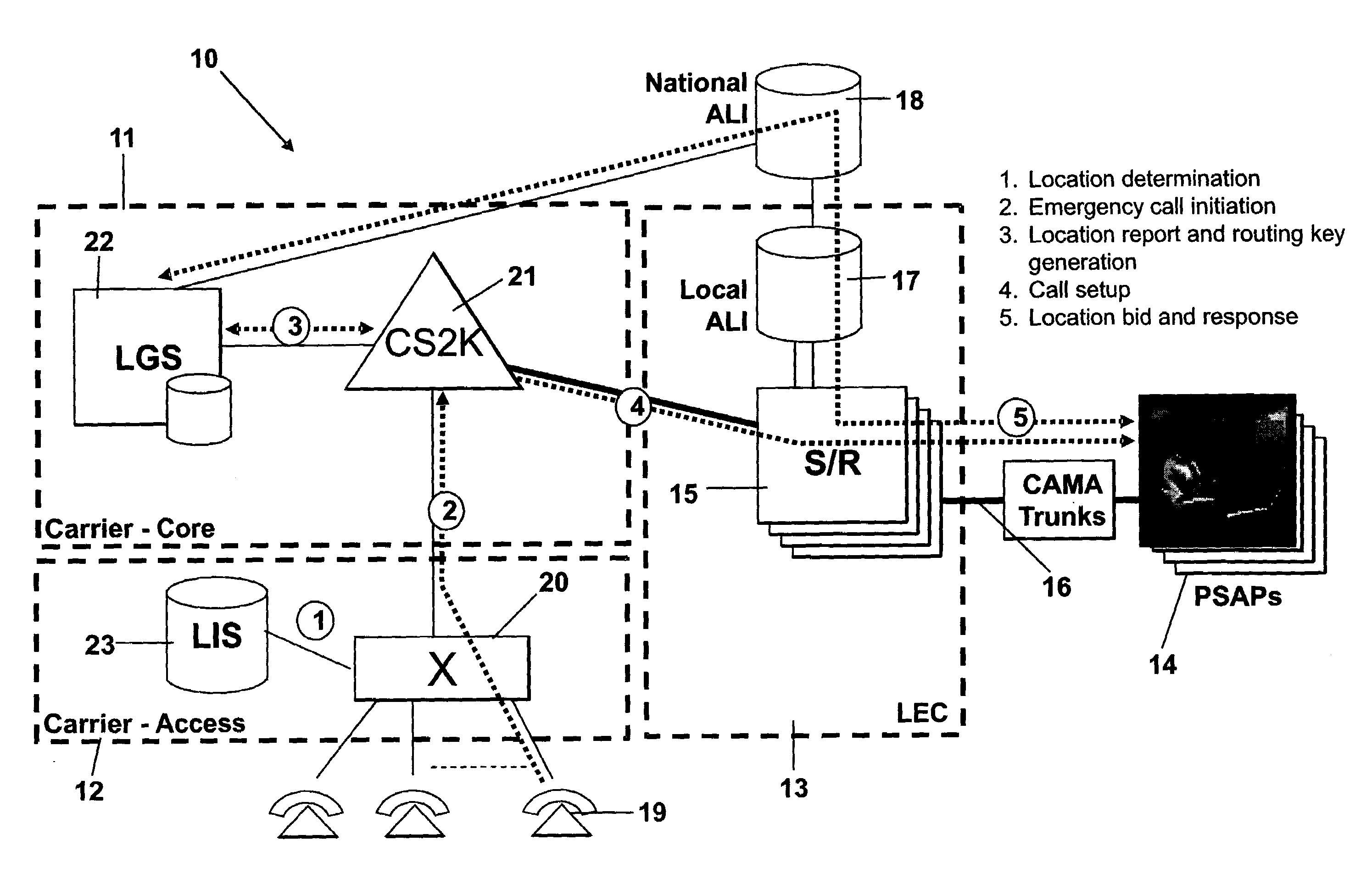
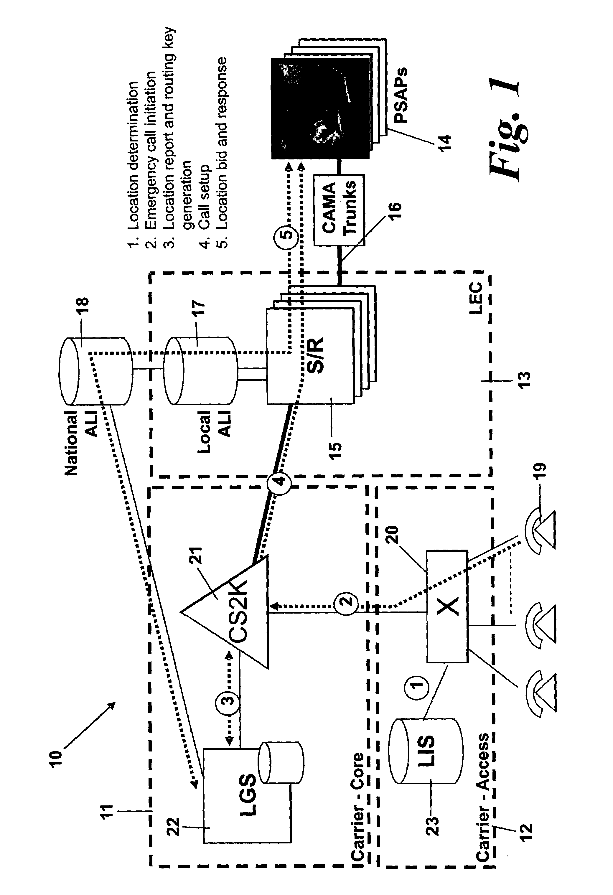
[0054]The term “geographical location information” is used to refer to information about the physical position of an entity in the physical environment as opposed to a communications network address. For example, it comprises a civic address, postal address, street address, latitude and longitude information or geodetic location information.

[0055]The term “nomadic communications system” is used to refer to a communications network in which user terminals can access the network from different, geographically separated, network access points without the need for modification of the terminal in order to access the network from those different access points.

[0056]FIG. 1 is a schematic diagram of a packet-based commun...


PUM


Abstract

In order that emergency service vehicles can be dispatched to the correct destination promptly, accurate information about the location of the caller is needed. Another problem concerns routing emergency calls to the correct destination. For emergency calls a universal code is used such as 911 in North America and 112 in Europe. This universal code cannot be used to identify the destination of the call. These problems are particularly acute for nomadic communications systems such as voice over internet protocol communications networks. That is because user terminals change network location. These problems are solved by enabling the geographical location of the emergency caller to be determined by entities within a packet-based network without the need for modification of existing emergency services network infrastructure.

Description

RELATED APPLICATION[0001]This application is the non-provisional filing of provisional application No. 60 / 548,746, filed Feb. 27, 2004.[0002]The present invention relates to a method and apparatus for determining the geographical location from which an emergency call originates in a packet-based communications network. The invention also relates to a method and apparatus for providing a routing key for routing an emergency call from a packet-based communications network node to an emergency services network node.BACKGROUND TO THE INVENTION[0003]There are a number of particular problems in dealing with emergency calls that do not arise for regular calls. For example, in order that emergency service vehicles or other assistance can be dispatched to the correct destination promptly, accurate information about the location of the caller is needed. Previously, in conventional switched telephone networks, it has been possible to provide the caller location information relatively easily be...

Claims


Application Information

Patent Timeline
Patent Type & Authority Patents(United States)
IPC IPC(8): H04M11/00H04M3/42H04M7/00
CPCH04M3/42229H04M7/006H04M3/42348H04M2242/30H04M2242/04
Inventor DAWSON, MARTIN CLEWIS, MARKBRODA, MACIEJ
Owner AVAYA INC
Why Eureka
Try Eureka