Aircraft synthetic vision systems utilizing data from local area augmentation systems, and methods for operating such aircraft synthetic vision systems

a technology of synthetic vision and aircraft, applied in traffic control systems, navigation instruments, instruments, etc., can solve the problems of poor visibility, instrument flight conditions, and the most difficult task a pilot undertakes, and achieve the effect of rapid initialization of data, constant refresh rate, and visual terrain information displayed on the screen

Active Publication Date: 2016-09-29
HONEYWELL INT INC
View PDF1 Cites 9 Cited by
  • Summary
  • Abstract
  • Description
  • Claims
  • Application Information

AI Technical Summary

Problems solved by technology

The approach to landing and touch down on the runway of an aircraft is probably the most challenging task a pilot undertakes during normal operation.
In some instances visibility may be poor during approach and landing operations, resulting in what is known as instrument flight conditions.
The usefulness of these SVS systems for approach and landing is limited, however, by the accuracy of the topographical database, particularly in the terminal area of the airport.
It has been discovered, for example, that in some instances, published terminal area topographical data may include unintended errors or biases in relation to the geographic position of certain features, such as runways, obstacles, etc.
If these errors or biases are then introduced into the SVS topographical databases, then the 3-D rendered images presented to the pilot on the SVS may not match the aircraft's actual environment, which is problematic in the context of flying a precision approach to the airport supplemented by the SVS.

Method used


Image

  • Aircraft synthetic vision systems utilizing data from local area augmentation systems, and methods for operating such aircraft synthetic vision systems
  • Aircraft synthetic vision systems utilizing data from local area augmentation systems, and methods for operating such aircraft synthetic vision systems
  • Aircraft synthetic vision systems utilizing data from local area augmentation systems, and methods for operating such aircraft synthetic vision systems

Examples


Embodiment Construction

[0013]The following detailed description is merely exemplary in nature and is not intended to limit the invention or the application and uses of the invention. As used herein, the word “exemplary” means “serving as an example, instance, or illustration.” Thus, any embodiment described herein as “exemplary” is not necessarily to be construed as preferred or advantageous over other embodiments. All of the embodiments described herein are exemplary embodiments provided to enable persons skilled in the art to make or use the invention and not to limit the scope of the invention which is defined by the claims. Furthermore, there is no intention to be bound by any expressed or implied theory presented in the preceding technical field, background, brief summary, or the following detailed description.

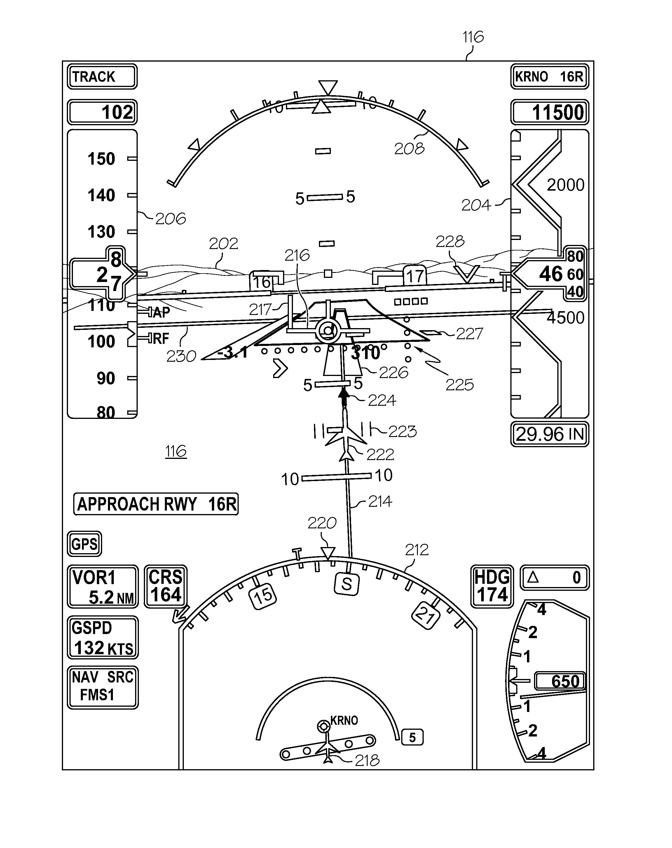
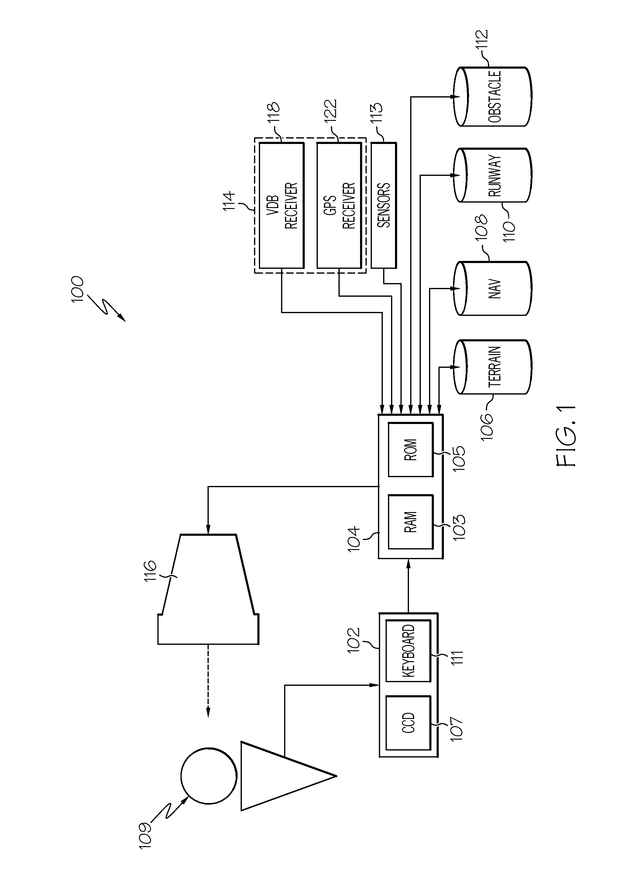
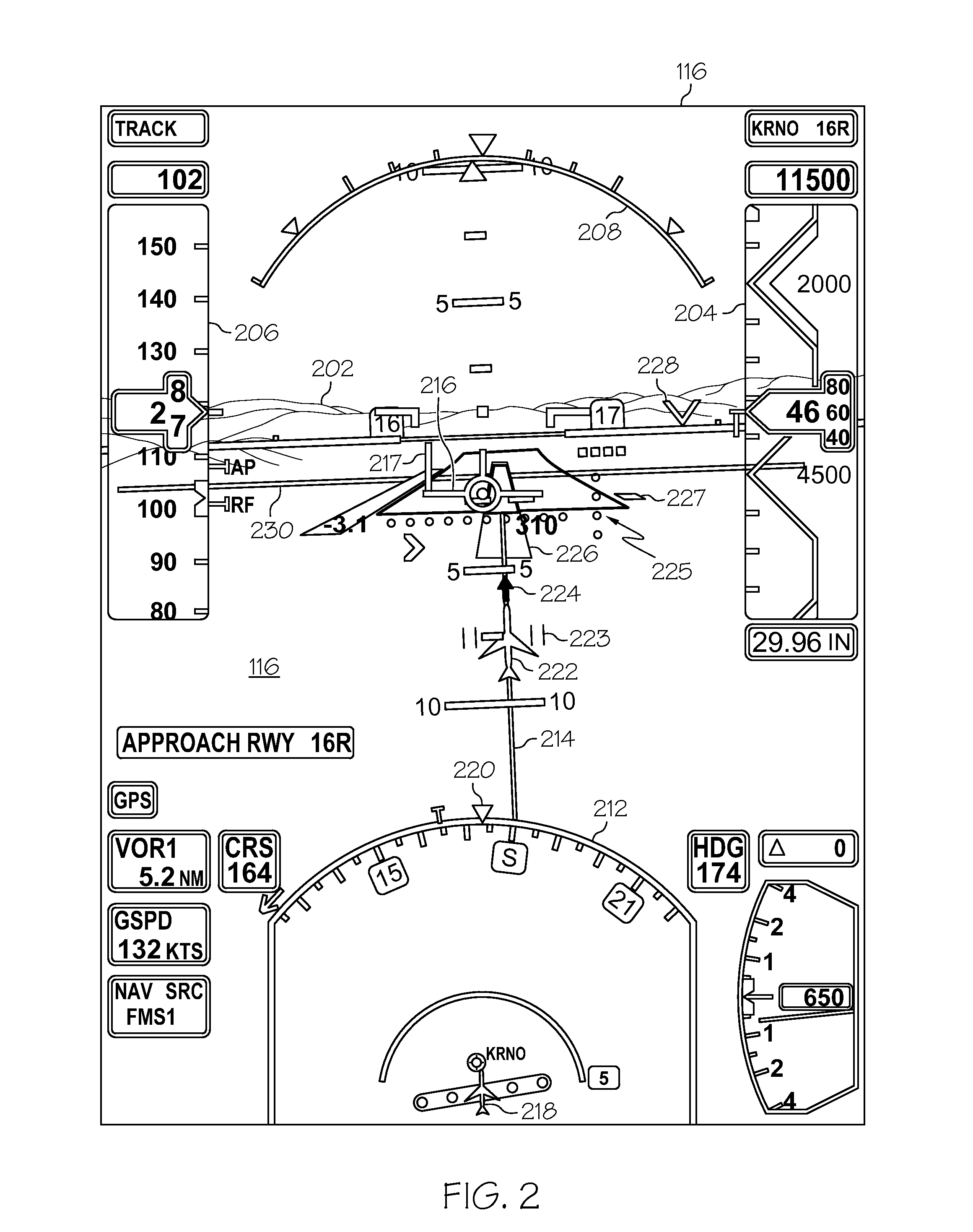
[0014]Embodiments of the present disclosure utilize ground-based data sources located at an airport, such as a local area augmentation system (LAAS), to validate the data from the topographical...


PUM


Abstract

An aircraft synthetic vision display system (SVS) includes a topographical database including topographical information relating to an airport, a global positioning system receiver that receives a satellite signal from a global positioning satellite to determine a geographical position of the aircraft, and a ground-based augmentation system receiver that receives a ground-based signal from a ground-based transmitter associated with the airport, wherein the ground-based signal includes geographical information associated with the airport. The SVS further includes a computer processor that retrieves the topographical information from the topographical database based on the geographical position of the aircraft, that retrieves the geographical information associated with the airport, and that corrects the topographical information using the geographical information associated with the airport to generate corrected topographical information. Still further, the SVS includes a display device that renders three-dimensional synthetic imagery of environs of the aircraft based on the corrected topographical information.

Description

TECHNICAL FIELD[0001]The present disclosure generally relates to aircraft display systems and methods for operating aircraft display systems. More particularly, the present disclosure relates to aircraft synthetic vision systems that utilize data from local area augmentation systems, and methods for operating such aircraft synthetic vision systems.BACKGROUND[0002]Many aircraft are equipped with one or more vision enhancing systems. Such vision enhancing systems are designed and configured to assist a pilot when flying in conditions that diminish the view from the cockpit. One example of a vision enhancing system is known as a synthetic vision system (hereinafter, “SVS”). A typical SVS is configured to work in conjunction with a position determining unit associated with the aircraft as well as dynamic sensors that sense aircraft altitude, heading, and orientation. The SVS includes or accesses a database containing information relating to the topography along the aircraft's flight pat...

Claims


Application Information

Patent Timeline
Patent Type & Authority Applications(United States)
IPC IPC(8): G01C21/00G01S19/42G08G5/00G01C21/20G01C23/00
CPCG01C21/005G01C21/20G01C23/00G08G5/0086G08G5/0078G08G5/0021G01S19/42G01C23/005G08G5/025G08G5/0013
Inventor WANG, GUOQINGZHANG, BINDU, LIN
Owner HONEYWELL INT INC
Why Eureka
Try Eureka