Traffic Obstruction Notification System Based on Wireless Vehicle Data

a technology of traffic obstruction and notification system, which is applied in the direction of road vehicle traffic control, traffic movement detection, instruments, etc., can solve the problems of conventional gps system only having an accuracy of plus or minus 10 meters, and the gps system cannot determine the location of a vehicle with lane-level accuracy

Active Publication Date: 2017-12-21
TOYOTA JIDOSHA KK
View PDF3 Cites 32 Cited by
  • Summary
  • Abstract
  • Description
  • Claims
  • Application Information

AI Technical Summary

Benefits of technology

[0006]A DSRC-compliant GPS unit can provide location data describing the location of a vehicle with lane-level accuracy. Lane level accuracy may mean that the location of a vehicle is described so accurately that the vehicle's lane of travel may be accurately determined. A conventional GPS system is unable to determine the location of a vehicle with lane-level accuracy. For example, a typical lane of a roadway is approximately 3 meters wide. However, a conventional GPS system may only have an accuracy of plus or minus 10 meters relative to the actual location of the vehicle.
[0007]A DSRC-compliant GPS unit may include hardware that wirelessly communicates with a GPS satellite to retrieve location data that describes a location of a vehicle with a precision that is compliant with the DSRC standard. The DSRC standard requires that location data be precise enough to infer if two vehicles are in the same lane. A DSRC-compliant GPS unit may be operable to identify, monitor and track its two-dimensional position within 1.5 meters of its actual position 68% of the time under an open sky. Since lanes of a roadway are typically no less than 3 meters wide, whenever the two dimensional error of the location data is less than 1.5 meters the estimation system described herein may analyze the location data provided by the DSRC-compliant GPS unit and determine what lane of the roadway the vehicle is traveling in based on the relative positions of vehicles on the roadway. In this way, the DSRC-compliant GPS unit may beneficially provide location data with lane-level accuracy.

Problems solved by technology

A conventional GPS system is unable to determine the location of a vehicle with lane-level accuracy.
However, a conventional GPS system may only have an accuracy of plus or minus 10 meters relative to the actual location of the vehicle.

Method used


Image

  • Traffic Obstruction Notification System Based on Wireless Vehicle Data
  • Traffic Obstruction Notification System Based on Wireless Vehicle Data
  • Traffic Obstruction Notification System Based on Wireless Vehicle Data

Examples


example deployment

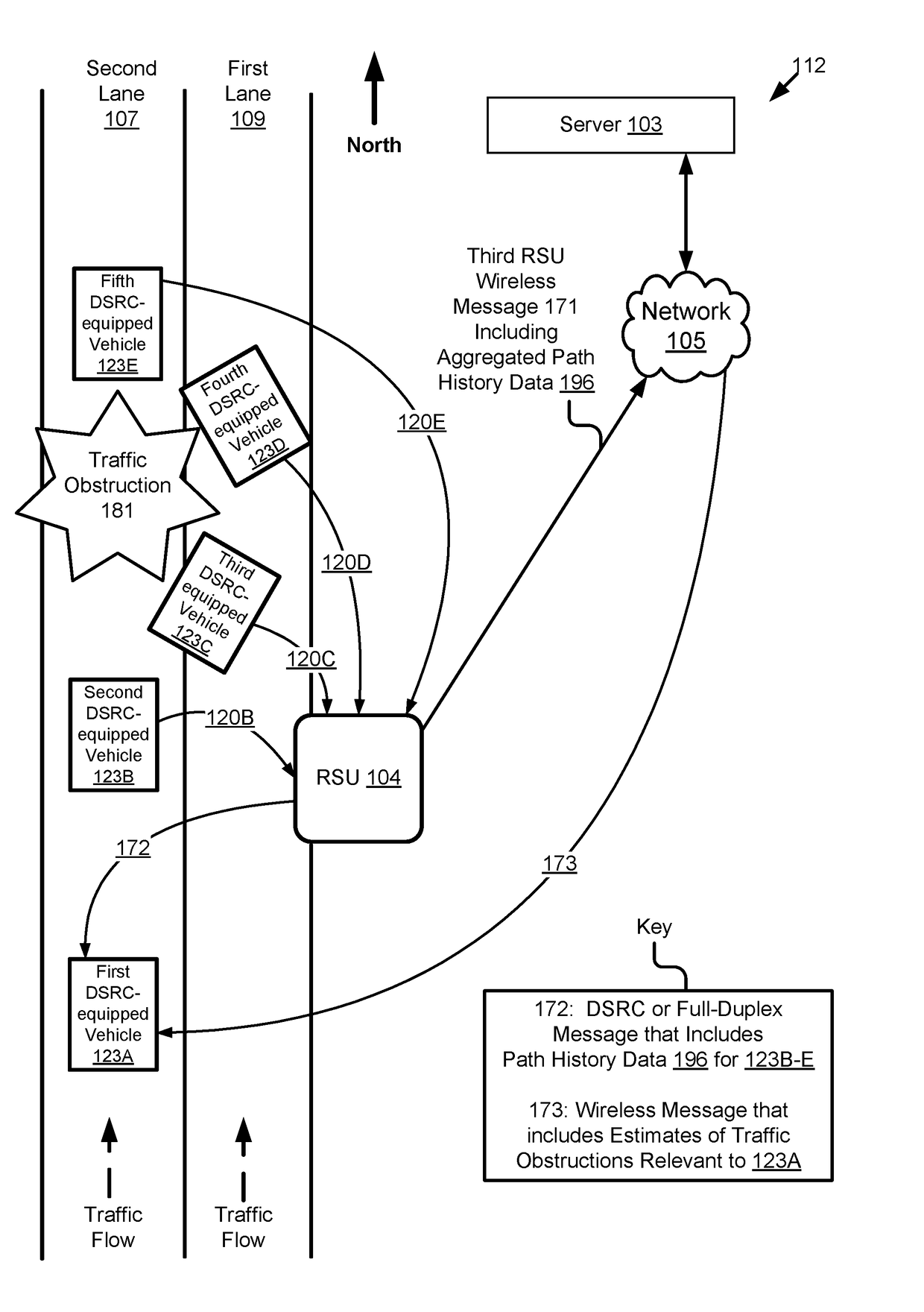
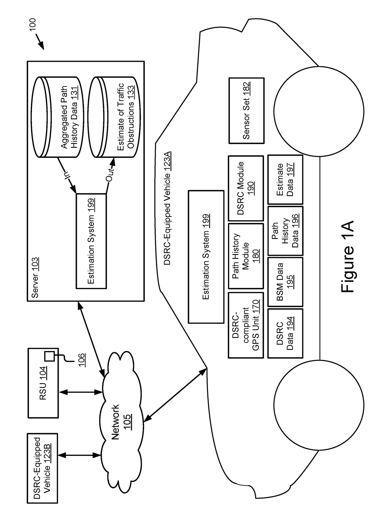
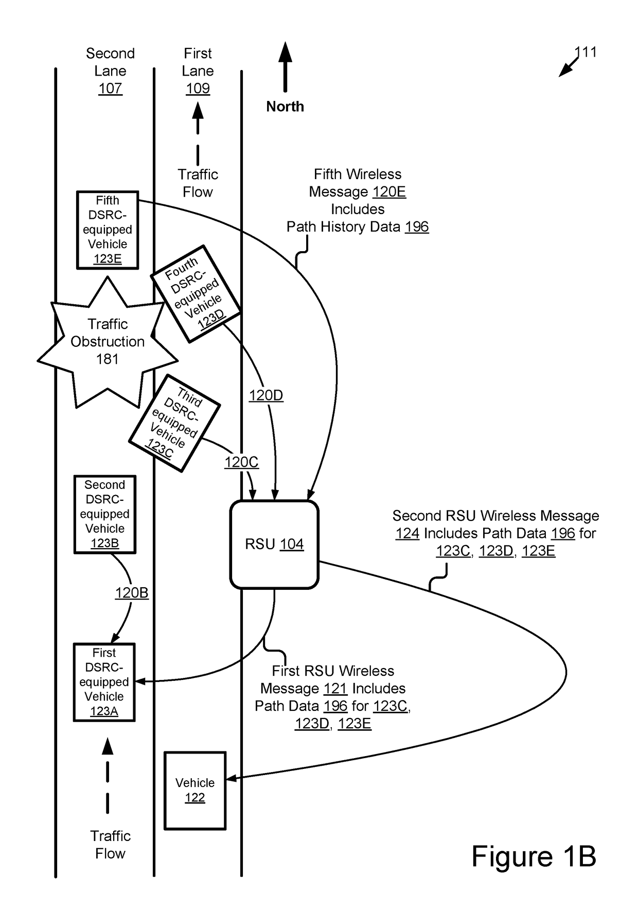
[0051]In some implementations, the estimation system may work by vehicles transmitting wireless messages to one another, an RSU or a cloud server. A wireless message may include the path history data for the vehicle which originally transmitted the wireless message.

[0052]In some implementations, an estimation system of a vehicle may receive one or more wireless messages, aggregate the path history data included in these wireless messages and estimate a presence of an obstruction based on the aggregated path history data.

[0053]In some implementations, a RSU may aggregate the path history data. The RSU may include an estimation system. The estimation system may provide batches of aggregated path history data to vehicles that are within transmission range of the RSU so that they may receive a wireless message from the RSU including a batch of aggregated path history data collected from a plurality of vehicles. The transmission range may include DSRC range, Wi-Fi range, full-duplex wire...


PUM


Abstract

The disclosure includes implementations for estimating a presence of an obstruction in a roadway using wireless vehicle data. A method may include receiving a Dedicated Short Range Communication (“DSRC”) message that includes path history data describing a path of a first DSRC-equipped vehicle with lane-level accuracy over a plurality of different times while the first DSRC-equipped vehicle is traveling on a roadway. The method may include determining a presence of an obstruction in a specific lane of the roadway based on the path history data. The obstruction may be indicated by the path history data because the path history data indicates that the obstruction affected the path of the first DSRC-equipped vehicle while traveling in the specific lane of the roadway. The method may include providing a recommendation to a driver of a second DSRC-equipped vehicle. The recommendation may describe the presence of the obstruction in the specific lane.

Description

BACKGROUND[0001]The specification relates to traffic obstruction notifications based on wireless vehicle data. The traffic obstruction notifications may be provided to a connected vehicle that is equipped with Dedicated Short Range Communication.[0002]Drivers of vehicles do not want to be at risk from traffic obstructions. Such obstructions include, for example: potholes; wrecks; animals; people; roadway debris; ice patches; puddles; or any other roadway condition that may cause a driver to modify the operation of the vehicle to avoid the obstruction. Interacting with such obstructions may be a safety risk for the driver or may damage the driver's vehicle.SUMMARY[0003]Described are implementations that include a system, method and a computer program product for providing a notification of a traffic obstruction based on wireless vehicle data included in a wireless message. The wireless message may include a Dedicated Short Range Communication (“DSRC”) message or some other type of wi...

Claims


Application Information

Patent Timeline
Patent Type & Authority Applications(United States)
IPC IPC(8): G08G1/01G08G1/0967
CPCG08G1/0141G08G1/0112G08G1/0967G08G1/0133G08G1/0129G08G1/096783
Inventor LU, HONGSHENGBANSAL, GAURAVKENNEY, JOHNNAKANISHI, TORU
Owner TOYOTA JIDOSHA KK
Why Eureka
Try Eureka