Method and apparatus for matching 3-dimensional terrain information using heterogeneous altitude aerial images

a technology of heterogeneous altitude and aerial images, applied in the field of methods and apparatus for matching 3d terrain information, can solve the problems of large time and expense, difficult to represent detailed parts, and differences in estimated positions and orientations, and achieve the effect of precise geometry matching

a technology of heterogeneous altitude and aerial images, applied in the field of methods and apparatus for matching 3d terrain information, can solve the problems of large time and expense, difficult to represent detailed parts, and differences in estimated positions and orientations, and achieve the effect of precise geometry matching

US20200202616A1Active Publication Date: 2020-06-25ELECTRONICS & TELECOMM RES INST

Image

  • Method and apparatus for matching 3-dimensional terrain information using heterogeneous altitude aerial images
  • Method and apparatus for matching 3-dimensional terrain information using heterogeneous altitude aerial images
  • Method and apparatus for matching 3-dimensional terrain information using heterogeneous altitude aerial images

Examples


Embodiment Construction

[0037]The present invention will be described in detail below with reference to the accompanying drawings. Repeated descriptions and descriptions of known functions and configurations which have been deemed to unnecessarily obscure the gist of the present invention will be omitted below. The embodiments of the present invention are intended to fully describe the present invention to a person having ordinary knowledge in the art to which the present invention pertains. Accordingly, the shapes, sizes, etc. of components in the drawings may be exaggerated in order to make the description clearer.

[0038]Hereinafter, a preferred embodiment of the present invention will be described in detail with reference to the accompanying drawings.

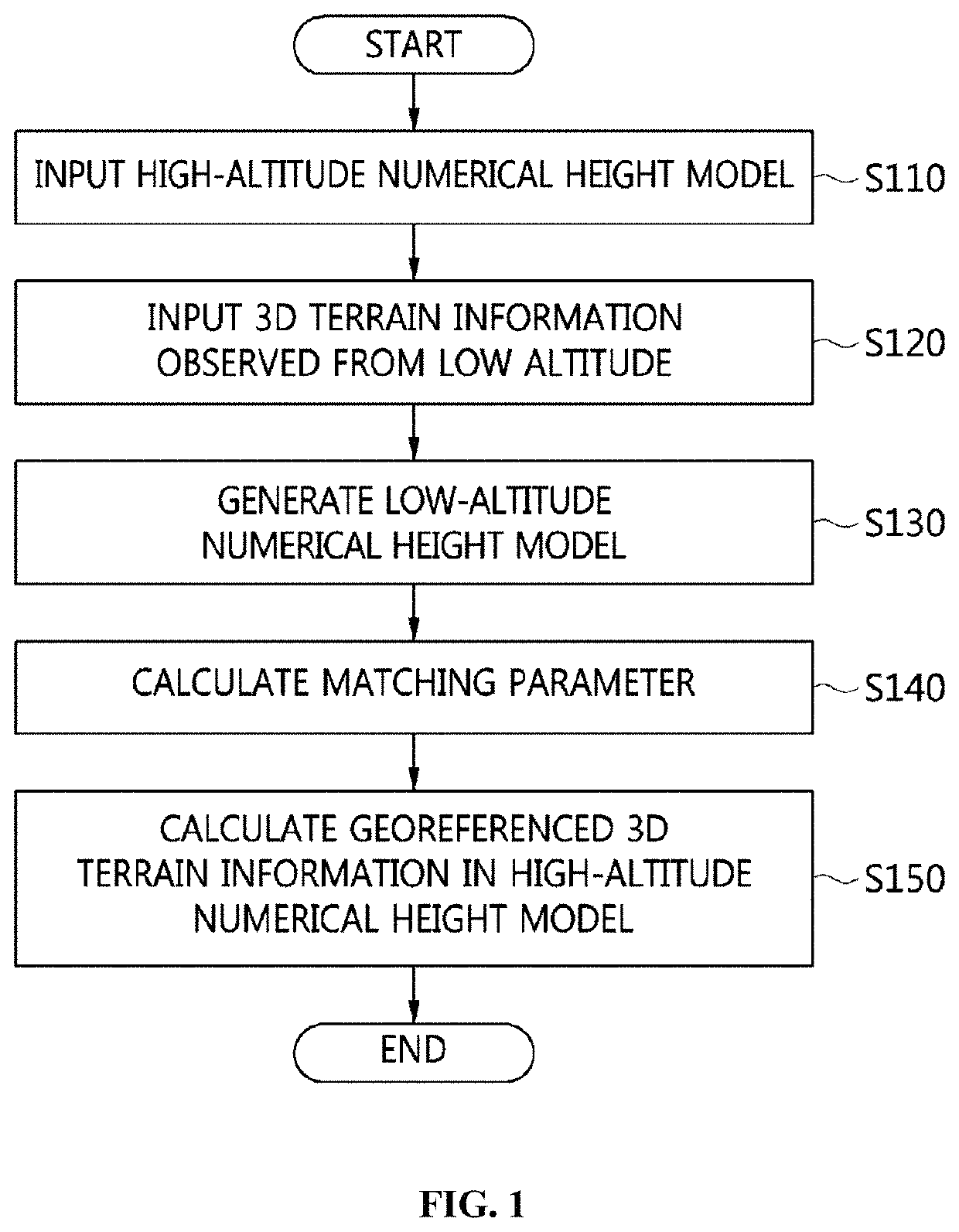
[0039]FIG. 1 is a flowchart for explaining a method for matching 3D terrain information using aerial images captured at different altitudes according to an embodiment of the present invention.

[0040]Referring to FIG. 1, in the method for matching 3D terrain i...


PUM


Abstract

Disclosed herein are a method and apparatus for matching 3D terrain information based on aerial images captured at different altitudes. The method includes receiving a high-altitude numerical height model based on a terrain image captured at a specific high altitude; receiving 3D terrain information observed from a low altitude, which is generated based on a terrain image captured at an altitude lower than the specific high altitude; generating a low-altitude numerical height model by converting the 3D terrain information into a numerical model in the same form as the high-altitude numerical height model; measuring the cross-correlation between the high-altitude numerical height model and the low-altitude numerical height model, thereby calculating matching parameters for enabling the low-altitude numerical height model to match the high-altitude numerical height model; and adjusting the geospatial coordinates of the 3D terrain information based on the matching parameters and outputting georeferenced 3D terrain information in the same coordinate system as the high-altitude numerical height model.

Description

CROSS REFERENCE TO RELATED APPLICATION[0001]This application claims the benefit of Korean Patent Application No. 10-2018-0167509, filed Dec. 21, 2018, which is hereby incorporated by reference in its entirety into this application.BACKGROUND OF THE INVENTION1. Technical Field[0002]The present invention relates generally to a method and apparatus for matching 3D terrain information using aerial images captured at different altitudes, and more particularly to a method and apparatus for matching 3D terrain information using aerial images captured at different altitudes, which enable pieces of 3D terrain information generated based on aerial images captured at different altitudes to be fused and used without previously measured Ground Control Point (GCP) data.2. Description of the Related Art[0003]3D terrain information, which includes the shapes and heights of terrain and aboveground features, may be generated by receiving satellite images, aerial images, aerial LiDAR data, or the like...

Claims


Application Information

Patent Timeline
25 Jun 2020
Publication
US20200202616A1
IPC
G06T17/05; G06T17/20; G06T19/20; G06T7/32
CPC
G06T2207/10032; G06T7/32; G06T17/05; G06T17/20; G06T2207/10028; G06T2207/20016; G06T2219/2016; G06T19/20
Inventors
YU, JUNG-JAE; KANG, KYUNG-KYU