Supercharge Your Innovation With Domain-Expert AI Agents!

Techniques for concurrently editing fully connected large-scale multi-dimensional spatial data

a multi-dimensional spatial and multi-dimensional technology, applied in the field of fully connected multi-dimensional spatial data editing, can solve the problems of inefficient approach, increased amount of processing and memory resources required to synchronize with the whole data, and concurrent edits

Active Publication Date: 2020-11-12
BENTLEY SYST INC
View PDF0 Cites 7 Cited by
  • Summary
  • Abstract
  • Description
  • Claims
  • Application Information

AI Technical Summary

Benefits of technology

The patent text describes techniques for editing large sets of spatial data that are fully connected and in multiple dimensions. The techniques prevent conflicts between edits and ensure that any edits that are not straightforward merges can be easily integrated. The system uses locks to prevent conflicts and tags boundaries of data with read-only properties to allow for safe editing. The technique ensures that edits can be easily merges together with other edits, regardless of order or complicating factors. Overall, the techniques enable efficient and safe editing of large multi-dimensional spatial data.

Problems solved by technology

When multiple clients perform jobs independently that edit the data, there is an issue of concurrent edits.
While workable, such approach is inefficient.
Among other issues, as the size of the fully-connected multi-dimensional spatial data grows, the amount of processing and memory resources required to synchronize with the whole data grows, eventually becoming impractical.
The base data set can be read by clients, but edit-sets generally are not comparable to or compatible with each other.
In still another existing approach, editing may be limited by tile boundaries.
However, this approach does not fully address the needs of concurrent edits.
Doing so is often difficult as tiles are typically computed independently of each other and are not always topologically connected.
Computing systems may not have the necessary resources to simultaneously edit many tiles, and there is often no way to synchronize edits among tiles.
Accordingly, editing multiple tiles may lead to data races where data is left in a corrupted state due to conflicting edits.
However, if the data lacks extensive structure or clients lack knowledge of the structure, the approach proves unworkable.
Object-based approaches often restrict concurrency to different object.
Further, object-based approaches typically do not consider influence of edits of one object to other objects due to connections therebetween.
Lack of such consideration may prove problematic, for example, in situations where to stay fully-connected the items of the data (e.g., vertices or edges) need to be affected by changes to neighboring data (e.g., neighboring vertices or edges).

Method used


Image

  • Techniques for concurrently editing fully connected large-scale multi-dimensional spatial data
  • Techniques for concurrently editing fully connected large-scale multi-dimensional spatial data
  • Techniques for concurrently editing fully connected large-scale multi-dimensional spatial data

Examples


Embodiment Construction

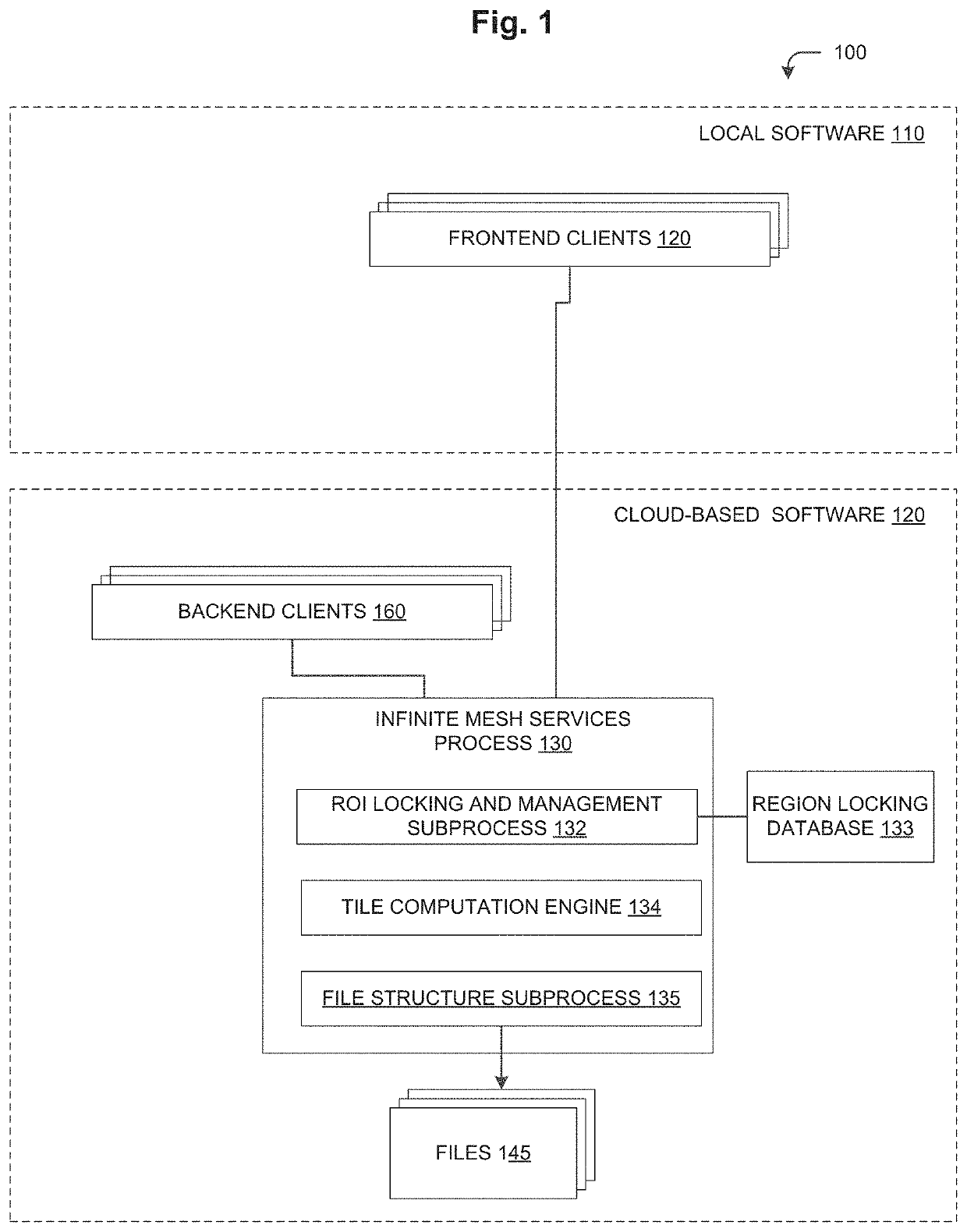
[0027]FIG. 1 is a high-level block diagram of an example software architecture 100 for a SfM photogrammetry application that generates fully-connected large-scale multi-dimensional spatial data. In an embodiment, where the fully-connected large-scale multi-dimensional spatial is a large-scale 3-D mesh, the dimensions may be height, width and depth. However, it should be understood that the data may have another numbers of dimensions and such dimensions may represent other information. For example, the data may be 4-dimensional data, with the fourth dimension representing time. In one embodiment, the SfM photogrammetry application operates to generate a large-scale 3-D mesh based on a set of images (e.g., photographs) of the real-world (source data) captured by a camera or cameras (not shown). However, it should be understood that other forms of source data may additionally, or alternatively, be utilized. For example, source data may include data captured by LiDAR, RGB-D cameras, or ...


PUM


Abstract

In an example embodiment, techniques are provided for concurrently editing fully-connected large-scale multi-dimensional spatial data (e.g., a large-scale 3-D mesh) by ensuring that edits performed by multiple clients are non-conflicting edits that are “trivially” mergeable (e.g. mergeable simply via cut-and-paste operations). Conflicting edits may be prevented by locks (e.g., region-based locks). Non-conflicting edits that require “non-trivial” merging may be prevented through the use of marked read-only boundaries.

Description

RELATED APPLICATIONS[0001]The present application claims the benefit of EP Patent Application No. 19 305 583.7 titled TECHNIQUES FOR EDITING FULLY CONNECTED LARGE-SCALE MULTI-DIMENSIONAL SPATIAL DATA, filed on May 7, 2019, the contents of which are incorporated herein in their entirety.BACKGROUNDTechnical Field[0002]The present disclosure relates generally to editing fully-connected multi-dimensional spatial data and more specifically to locking techniques applicable to fully-connected large-scale multi-dimensional spatial data to permit collaborative operation.Background Information[0003]It may be useful in a variety of software applications for multiple clients (e.g., software programs or human users) to collaboratively operate upon fully-connected large-scale (e.g., potentially infinitely large) multi-dimensional (e.g., two-dimension (2-D), three-dimensional (3-D), four-dimensional (4-D), etc.) spatial data. Such collaborative operation may enable greater concurrency and parallel...

Claims


Application Information

Patent Timeline
Patent Type & Authority Applications(United States)
IPC IPC(8): G06T19/20G06T17/20G01C11/04
CPCG06T2219/2008G06T2219/004G06T19/20G01C11/04G06T2200/24G06T2219/2004G06T2219/024G06T17/205G06F16/29G06F16/2343
Inventor GODZARIDIS, ELENIEROBERT, LUCPONS, JEAN-PHILIPPENULLANS, STEPHANE
Owner BENTLEY SYST INC
Features
  • R&D
  • Intellectual Property
  • Life Sciences
  • Materials
  • Tech Scout
  • Unparalleled Data Quality
  • Higher Quality Content
  • 60% Fewer Hallucinations
Learn More